This item has been sold, but you can get on the Waitlist to be notified if another example becomes available, or purchase a digital scan.
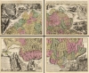
1715 Schenk / Scheuchzer Illustrated Map of Switzerland on Four Sheets
Switzerland-schenk-1715$2,250.00


Title
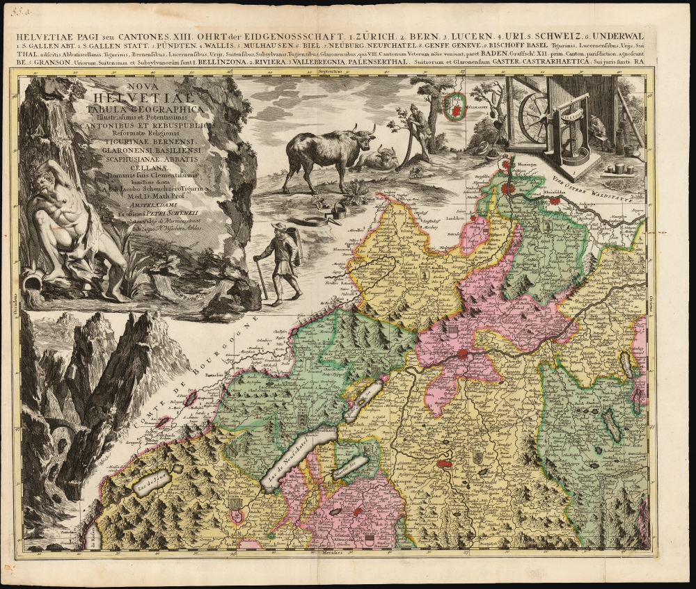
Nova Helvetiae Tabula Geographica Illustrissimis et Potentissimis Cantonibus et Rebuspublicis Reformatae Religionis Tigurinae, Bernensi Scaphusianae, Abbatis Cellanae...
1715 (undated) 37 x 45 in (93.98 x 114.3 cm) 1 : 380000
1715 (undated) 37 x 45 in (93.98 x 114.3 cm) 1 : 380000
Description
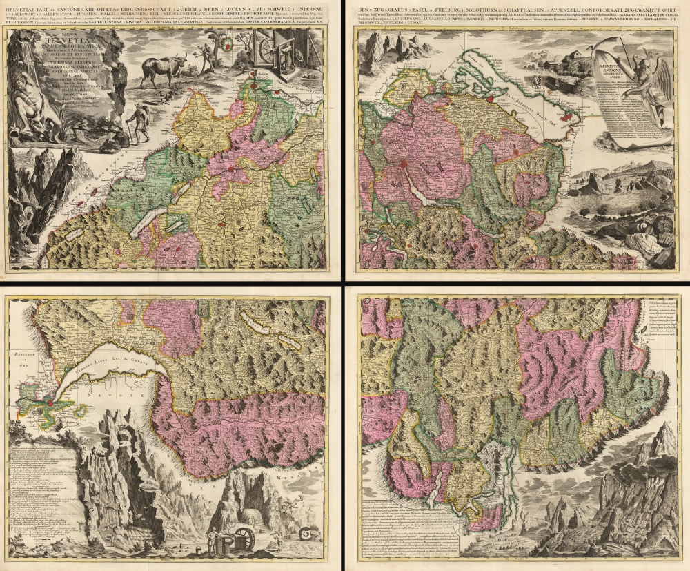
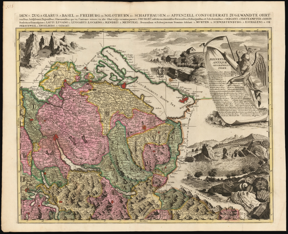
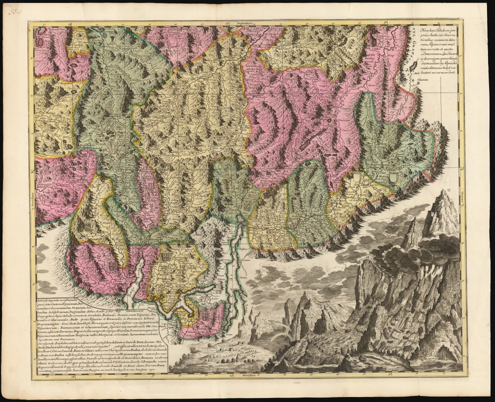
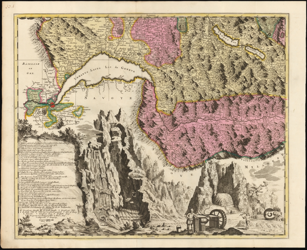
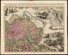
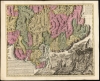
This is Johann Jacob Scheuchzer's four-sheet map of Switzerland in its spectacular 1715 Pieter Schenk Amsterdam edition. Map historian Tony Campbell wrote, 'Its borders make it probably the most handsome map ever produced of Switzerland; yet the carefully labeled tableaux were intended as scientific illustrations, not just decoration.' Schenk's edition is brighter and more legible than the Zurich edition.
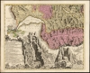
The illustration includes not only the Lucerne Dragon, but also a famous artifact: the Lucerne Drachenstein (Dragonstone). This orb - depicted without the benefit of scale and, therefore, seemingly vast, despite actually being the size of an apple - was believed to harbor healing powers. Lucerne tradition of the 15th century records that a farmer had sighted the Lucerne Dragon, which dropped the stone: a ball, covered with clotted blood. Following reports that the stone miraculously cured diseases, it was passed from family to family until acquired by the Canton of Lucerne in 1929. (Today it is displayed in the Nature Museum in Lucerne.) Although long theorized to be or to contain a meteorite, a 2006 study determined the Drachenstein to be fired clay. Its origin, nonetheless, remains obscure.
A Milestone Map
The map was based on the travels of Swiss historian and alpinist Johann Jacob Scheuchzer, who produced the first systematic natural history of the Swiss Confederacy, having traveled the mountains of his country extensively to support his studies. In its 1712 edition, it was the best map of Switzerland based on firsthand reports. The map captures Switzerland immediately following the 1712 Swiss Civil War, or Toggenburg War. Fought between Catholic and Protestant cantons, the war ended in a Protestant victory. The title alludes to the war, dedicating the map to the leaders of the Protestant cantons; its content also distinguishes Catholic towns from Protestant.A Closer Look
The scale permitted greater detail than any earlier map, and Schenk's edition is solidly faithful to the detail Scheuchzer source map. In reproducing Scheuchzer's pictorial mountains, Schenk pared them back to improve the legibility of his place names, roads, and cities. In depicting towns and villages, the map distinguishes between those affiliated with the Catholic Church and those with the Reformed Church. Switzerland's cantons are divided with engraved borders illuminated with original outline and wash color; each features its coat of arms.A Masterpiece of Illustration
At the upper left is an allegorical cartouche, artfully framed with mountains and rivers, with a titan (representing The Rhine) pouring water from a jug. At the upper right, Father Time (elderly, winged, with a scythe and balancing a winged hourglass on his head) points out a table listing Switzerland's ancient placenames. But well beyond these, the map showcases Schenk's decorative engraving, which reinterpreted Scheuchzer's original drawings - applying aesthetic improvements while retaining the originals' content. This is important as the illustrations were taken from Scheuchzer's firsthand observations, many of which appeared in Beschreibung der Natur-Geschichten des Schweizerlands and later works. Happily, the illustrations are number-keyed to a list of explanations in the lower left. Some are rather mundane: novel methods of making cheese, and illustrations of the tools involved; methods of sod farming; and the means of turning and hollowing iron pots. But the real glories of the engraving focus on natural phenomena and the Alps themselves. There are depictions of ball lightning, landslides, and alpine floods (the latter displaying a hapless victim in the rushing water). The map features a stunning depiction of the Teüffelsbruk, or 'Devil's Bridge' spanning the Schöllenen Gorge, with the upper Reuss raging below. Other illustrations include the Rhinefalls, with the ancient Laufen Castle overlooking them; the awesome, precipitous Gemmi Pass in the Bernese Alps, with its waterfall displaying a circular rainbow at its feet; Scheuchzer's drawing of the Rhône Glacier; and the mountain lake Lai da Calandari (by which it was believed one could predict storms). Scheuchzer also presents the monumental Pizzas d'Anarosa in Grisons, marking the site of an old tower and the point beyond which no trees grow on the mountain. Also depicted are Scheuchzer's drawings of fossils, the study of which had gained him election to the Royal Society, and which he believed to be evidence of the Biblical Deluge.Here Be Dragons
Strange to say, this is among the only printed maps to depict a dragon - the Lucerne Dragon, believed to dwell in the caverns of Mount Pilatus. The region around Lucerne had spawned an array of dragon legends, some quite detailed. The forbidding topology of the Alps resulted in many hidden and remote valleys and forests, and these proved apt to nurturing reports of strange creatures. Scheuchzer dedicated a chapter of his Itinera Alpina to reports of dragon encounters - one eyewitness claiming to have observed a flying, fire-breathing dragon. Although Scheuchzer was often skeptical about such reports - noting that 'dragon's bones' were likely from less fantastic animals such as bears - this did not prevent him from depicting dragons in his works.The illustration includes not only the Lucerne Dragon, but also a famous artifact: the Lucerne Drachenstein (Dragonstone). This orb - depicted without the benefit of scale and, therefore, seemingly vast, despite actually being the size of an apple - was believed to harbor healing powers. Lucerne tradition of the 15th century records that a farmer had sighted the Lucerne Dragon, which dropped the stone: a ball, covered with clotted blood. Following reports that the stone miraculously cured diseases, it was passed from family to family until acquired by the Canton of Lucerne in 1929. (Today it is displayed in the Nature Museum in Lucerne.) Although long theorized to be or to contain a meteorite, a 2006 study determined the Drachenstein to be fired clay. Its origin, nonetheless, remains obscure.
Publication History and Census
The Swiss naturalist Johann Jacob Scheuchzer drew the map in 1712, after which it was separately published in Zurich. In 1715, Pieter Schenck produced this edition in Amsterdam. It, too, was separately issued, but was also included in late editions of the Atlas Minor of Nicolas Visscher II. The separate sheets are well represented in institutional collections, but complete, matched sets are scarce on the market.CartographerS
Petrus Schenk (Pieter Schenck) the Elder (December 26, 1660 - 1711) was a Dutch engraver, globe maker, and map publisher active in Amsterdam and Leipzig in the latter half of the 17th century. Schenk, was born in Elberfield, Germany. He moved in Amsterdam in 1675, becoming the apprentice to Gerard Valk (Valck). In 1687, Schenk married Agatha Valk, Gerard Valk's sister and went into partnership with his brother-in-law under the imprint of 'Valk and Schenk'. Initially they focused on maps and atlases, acquiring the map plates of Jan Jansson and Jodocus Hondius in 1694. Later, in 1701 they moved into the former Hondius offices where they began producing globes. Valk and Schenk quickly became known for producing the best globes in the Netherlands, a business on which they held a near monopoly for nearly 50 years. Schenk's three sons, Pieter Schenk the Younger, Jan Schenk, and Leonard Schenk, all became engravers in their own right. Pieter Schenk the Younger inherited the business and ran his father's shop in Leipzig. His daughter, Maria Schenk, married Leonard Valk, the son of Gerard Valk, and continued to run the Valk and Schenk map engraving workshop in Amsterdam. More by this mapmaker...
Johann Jakob Scheuchzer (August 2, 1672 - June 23 1733) was a Swiss naturalist and physician. He was born in Zurich to an academic family and educated as a physician. In addition, he studied mathematics and astronomy. Upon completion of his studies, he became Zurich's town physician, a professor of mathematics, and a lecturer in philosophy. He was broadly published and a vigorous correspondent; he was elected a Fellow of the Royal Society in 1703, mainly on the strength of his studies on fossils. He produced a natural history of Switzerland, and as an alpinist, traveled throughout the country. His strictly historical writings were never published, but survive in manuscript. He is further known for his Biblical commentary, Physica Sacra, a reconciliation of science and religion; also, his Natural History of Switzerland, which he published in three volumes between 1706 and 1708. His Itinera Alpina, published in the 1720s, was among the first detailed descriptions of the Alpine landscape. He is known to have produced one map, the four-sheet Nova Helvetiae Tabula Geographica, published in the wake of the 1712 Toggenburg War. The map was influential and copied shortly after by Pieter Schenk, Covens and Mortier, and others. Learn More...
Condition
Very good. Few marginal splits just entering printed image with no loss; few small spots, else an excellent matched set with complete margins, uniform strikes, and rich original color. Size given for full composition if joined; each sheet measures 18.5 x 22.5 inches.
References
OCLC 1332421903. cf Campbell, T. Early Maps., pp. 104-105, pl. 48.