This item has been sold, but you can get on the Waitlist to be notified if another example becomes available, or purchase a digital scan.
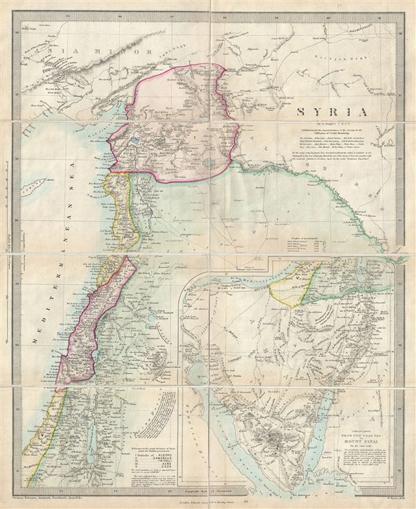
1858 W. Hughes Map of Syria, Israel and Holy Land (with Sinai Peninsula, Egypt)
Syria-hughes-1858$125.00

Title
Syria.
1858 (dated) 16.5 x 13.5 in (41.91 x 34.29 cm) 1 : 2200000
1858 (dated) 16.5 x 13.5 in (41.91 x 34.29 cm) 1 : 2200000
Description
This is a scarce 1858 map of Syria, Israel and the Holy Land prepared by William Hughes. Centered on Syria, it covers from Asia Minor to the Dead Sea. The map is continued on the same scale, from the Dead Sea to Mount Sinai, in a large inset in the lower right quadrant. The modern day nations of Turkey, Syria, Lebanon, Jordan, Israel, and Egypt are included. The map notes the route of the Egyptian Haj to Mecca and the route of the Syrian Haj to Mecca. The sites of numerous ancient ruins and monuments are identified as are cities with ancient and contemporary place names.
This time in history marks the decline of the Ottoman empire. Syria was part of the Ottoman Empire and largely ignored by world affairs. The map notes the administrative divisions of the Ottoman Empire which include the Pachalic of Gaza, Pachalic of Acre, Pachalic of Tripoli, Pachalic of Aleppo and the Pachalic of Damascus.
Several rivers, lakes, mountains, desert and an assortment of additional topographical features are noted with relief shown by hachure. This map is exceptionally scarce as it is issued as a pocket map, rather than the more common atlas edition of the same. Boundaries are outlined in vivid color. This map was drawn and engraved in 1858 by W. Hughes under the superintendence of the Society for the Diffusion of Useful Knowledge and issued as a pocket map by Edward Stanford, 6, Charing Cross.
Cartographer
The "Society for the Diffusion of Useful Knowledge" (1826 - 1848) was a Whiggish organization founded in 1828 at the instigation of idealistic British lord Henry Peter Brougham. The admirable goal of the Society was to distribute useful information via a series of publications to the English working and middle classes. It promoted self-education and the egalitarian sharing of all knowledge. While closely tied to the London University and publishing houses on the order of Baldwin and Cradock, Chapman and Hall, and Charles Knight, the Society failed to achieve its many lofty goals in finally closed its doors in 1848. Most likely the failure of the Society resulted from its publications being too expensive for its intended lower to middle class markets and yet not large and fine enough to appeal to the aristocratic market. Nonetheless, it did manage to publish several extraordinary atlases of impressive detail and sophistication. Their most prominent atlas consisted of some 200 separately issued maps initially published by Baldwin and Cradock and sold by subscription from 1829 to 1844. Afterwards, the Society combined the maps into a single world atlas published under the Chapman and Hall imprint. In its day, this atlas was unprecedented in its quality, scope, and cost effectiveness. Today Society, or S.D.U.K. as it is commonly known, maps are among the most impressive examples of mid-19th century English mass market cartographic publishing available. The S.D.U.K. is especially known for its beautiful and accurately detailed city plans. More by this mapmaker...
Condition
Very good. Dissected and mounted on linen. Minor toning along original fold lines. Accompanied by original binder.
References
Rumsey 0890.083 (1843 atlas edition). Phillips (atlases) 794.