This item has been sold, but you can get on the Waitlist to be notified if another example becomes available, or purchase a digital scan.
1588 Sebastian Munster Map of Sumatra and Malay (Malaysia)
TabrobanaSumatraMalay-munster-1588$475.00

Title
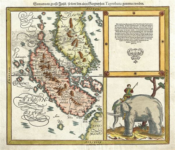
Sumatra ein grosse Insel so von den alten Geographen Taprobana genennt worden.
1588 (undated) 13 x 15 in (33.02 x 38.1 cm) 1 : 6000000
1588 (undated) 13 x 15 in (33.02 x 38.1 cm) 1 : 6000000
Description
A spectacular 1588 Sebastian Munster map of Malay and Sumatra and one of the one of the earliest to specifically illustrate this region. Munster issued this map in the 1588 edition of his Cosmographia, an expansion upon the classical geography of Claudius Ptolemy that attempted to include recently discovered parts of the world. The map covers the southern parts of the Malay Peninsula (roughly what is Malaysia today), the entirety of Sumatra, and parts of adjacent Java and the Straits of Sunda. A city roughly situated where Singapore is today is identified as 'Cingafufa.' This has nothing to do with the city of Singapore as we know it today, but, it may have been the source for the term 'Singapore.'
This map is an update of an early map by Munster issued in 1550. There was a great deal of confusion in 16th century Europe with regard to the island of Tapobrana. While Tapobrana is most commonly associated with Ceylon (Sri Lanka), from the 15th century onward it was also identified with Sumatra. The earliest editions of Munster's Cosmographia featured a similar map that resembled Ceylon in form, but was positioned relative to the Malay Peninsula and the Equator where Sumatra actually rests. He updated the map in this, its second edition, to more accurately portray Sumatra both inform and content.
This map was drawn by Sebastian Henric Petri, Munster's step-grandson. It seems that Sumatra was surprisingly well known at the time with numerous locations correctly identified. Malay is far more vauge, though the cartograph does successfully name Queda (Kedah), Pera (Perak), Malacca, Muhar (Muar), Paam (Pahang), and Calanton (Kelantan).
An elephant and mahout appears in the lower left quadrant. The upper right quadrant includes a quotation from Pliny. Issued in the 1588 edition of Sebastian Munster's Cosmographia.
Cartographer
Sebastian Münster (January 20, 1488 - May 26, 1552), was a German cartographer, cosmographer, Hebrew scholar and humanist. He was born at Ingelheim near Mainz, the son of Andreas Munster. He completed his studies at the Eberhard-Karls-Universität Tübingen in 1518, after which he was appointed to the University of Basel in 1527. As Professor of Hebrew, he edited the Hebrew Bible, accompanied by a Latin translation. In 1540 he published a Latin edition of Ptolemy's Geographia, which presented the ancient cartographer's 2nd century geographical data supplemented systematically with maps of the modern world. This was followed by what can be considered his principal work, the Cosmographia. First issued in 1544, this was the earliest German description of the modern world. It would become the go-to book for any literate layperson who wished to know about anywhere that was further than a day's journey from home. In preparation for his work on Cosmographia, Münster reached out to humanists around Europe and especially within the Holy Roman Empire, enlisting colleagues to provide him with up-to-date maps and views of their countries and cities, with the result that the book contains a disproportionate number of maps providing the first modern depictions of the areas they depict. Münster, as a religious man, was not producing a travel guide. Just as his work in ancient languages was intended to provide his students with as direct a connection as possible to scriptural revelation, his object in producing Cosmographia was to provide the reader with a description of all of creation: a further means of gaining revelation. The book, unsurprisingly, proved popular and was reissued in numerous editions and languages including Latin, French, Italian, and Czech. The last German edition was published in 1628, long after Münster's death of the plague in 1552. Cosmographia was one of the most successful and popular books of the 16th century, passing through 24 editions between 1544 and 1628. This success was due in part to its fascinating woodcuts (some by Hans Holbein the Younger, Urs Graf, Hans Rudolph Manuel Deutsch, and David Kandel). Münster's work was highly influential in reviving classical geography in 16th century Europe, and providing the intellectual foundations for the production of later compilations of cartographic work, such as Ortelius' Theatrum Orbis Terrarum Münster's output includes a small format 1536 map of Europe; the 1532 Grynaeus map of the world is also attributed to him. His non-geographical output includes Dictionarium trilingue in Latin, Greek, and Hebrew, and his 1537 Hebrew Gospel of Matthew. Most of Munster's work was published by his stepson, Heinrich Petri (Henricus Petrus), and his son Sebastian Henric Petri. More by this mapmaker...
Source
Munster, S., Cosmographica, (Basel) 1588.
The Cosmographia Universalis, one of the greatest geographical and historical works of the 16th century, 'taught nearly three generations of laymen most of what they knew about the world beyond their native places' (Strauss). Filled with maps, views, and rich descriptions of places throughout Europe and beyond, it was the best general source of geographical information until the advent of Ortelius' Theatrum. It was first issued by Sebastian Munster (1488 - 1552) in its 1544 German edition, and stayed in print long after its author's death in thirty five editions, and in five languages. (Of these, the 1550 and 1552 editions are widely regarded as the most complete and truest to the author's intentions: thereafter, later editors continued to add to the work's text; editions from 1588 onwards employed an entirely different set of maps produced on Ortelius' model.) Munster's goal, initially, was to rally his homeland's humanists and scholars to produce a new map of Germany in order to 'see what kind of a land our ancestors conquered for their home... bring honor to our country and place its beauties in the clear light of day.' Munster's project quickly expanded to cover the known world in its scope to produce a 'sufficiently large volume, in which I touch upon the foundation of all nations and kingdoms, their peculiarities, rivers, mountains, customs of men, royal successions, origins of the more important cities, succinct histories, religions, characteristics and fertility of lands... in Germany, however, I tarry a little longer'.
Munster's methodology in Cosmographia is notable in particular for his dedication to providing his readers with direct access to firsthand reports of his subjects wherever possible. Many of the maps were the result of his own surveys; others, the fruit of an indefatigable letter writing campaign to scholars, churchmen and princes throughout Europe, amicably badgering them for maps, views, and detailed descriptions of their lands. For lands further afield than his letters could reach, Munster relied on the best that the authorities of northern European scholarship could offer: he was well familiar with the work of Waldseemuller and other geographers of the early 16th century, and was well connected with the best geographers of his own generation. A disproportionate number of the maps of Cosmographia show contemporary geographical knowledge of the their respective areas for the very first time: The first map to show the continents of the Western Hemisphere; the first map to focus on the continent of Asia; the first modern map to name the Pacific Ocean; the first map to use a key; the first modern map of the British Isles and so on. Even in cases where earlier maps exist, Munster's works very often remain the earliest such acquirable by the collector.
Munster's methodology in Cosmographia is notable in particular for his dedication to providing his readers with direct access to firsthand reports of his subjects wherever possible. Many of the maps were the result of his own surveys; others, the fruit of an indefatigable letter writing campaign to scholars, churchmen and princes throughout Europe, amicably badgering them for maps, views, and detailed descriptions of their lands. For lands further afield than his letters could reach, Munster relied on the best that the authorities of northern European scholarship could offer: he was well familiar with the work of Waldseemuller and other geographers of the early 16th century, and was well connected with the best geographers of his own generation. A disproportionate number of the maps of Cosmographia show contemporary geographical knowledge of the their respective areas for the very first time: The first map to show the continents of the Western Hemisphere; the first map to focus on the continent of Asia; the first modern map to name the Pacific Ocean; the first map to use a key; the first modern map of the British Isles and so on. Even in cases where earlier maps exist, Munster's works very often remain the earliest such acquirable by the collector.
Condition
Very good. Minor repairs bottom center. Else clean. German decorative text on verso.
References
Durand, Fr., Curtis, R., Maps of Malaysia and Borneo: Discovery, Statehood, and Progress, no. 13. National Library of Australia, MAP RM 4386. OCLC 308718053.