This item has been sold, but you can get on the Waitlist to be notified if another example becomes available, or purchase a digital scan.
1588 Sebastian Munster Map of Sumatra and Malay (Malaysia)
TabrobanaSumatraMalay-munster-1588-2$275.00

Title
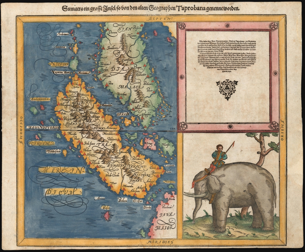
Sumatra ein grosse Insel so von den alten Geographen Taprobana genennt worden.
1588 (undated) 12.75 x 14.25 in (32.385 x 36.195 cm) 1 : 10000000
1588 (undated) 12.75 x 14.25 in (32.385 x 36.195 cm) 1 : 10000000
Description
This woodcut map of Malay and Sumatra - one of the earliest maps to specifically illustrate this region using contemporaneous geography - was added to Münster's Cosmographia in 1588, as part of Sebastian Petri's extensive update of the work.
The map's detail is partially drawn from Abraham Ortelius' 1570 Indiae Orientalis, but unlike many of Petri's new maps, it incorporates many placenames not found on the original.
It replaced an identically-titled map initially included in the work that had long been obsolete. Sebastian Petri, Münster's step-grandson and heir to Münster's publisher Heinrich Petri, updated the maps of Cosmographia extensively, replacing them with woodcuts based on Ortelius. Münster's original presented the island of Taprobana following the ancient Ptolemaic model, despite suggesting that the place might actually refer to Sumatra and placing it in the correct (Sumatran) location relative to the Malay Peninsula and the Equator. Petri solidly associated Taprobana with Sumatra by applying the ancient placename to the modern mapping of Sumatra, dispensing with the Ptolemaic island entirely.
Here, Sumatra is well-detailed, with numerous locations correctly identified. Malay is vague, though the cartographer does successfully name Queda (Kedah), Pera (Perak), Malacca, Muhar (Muar), Paam (Pahang), and Calanton (Kelantan).
Petri's version of the map shares the decoration of the Münster original: an elephant and mahout appear in the lower right, and the upper right includes a quotation from Pliny.
A Closer Look
The map covers the southern parts of the Malay Peninsula, the entirety of Sumatra, and parts of adjacent Java and the Straits of Sunda. A city roughly where Singapore is today is identified as 'Cingafufa.' This has nothing to do with the modern city of Singapore, but may be etymologically related.The map's detail is partially drawn from Abraham Ortelius' 1570 Indiae Orientalis, but unlike many of Petri's new maps, it incorporates many placenames not found on the original.
It replaced an identically-titled map initially included in the work that had long been obsolete. Sebastian Petri, Münster's step-grandson and heir to Münster's publisher Heinrich Petri, updated the maps of Cosmographia extensively, replacing them with woodcuts based on Ortelius. Münster's original presented the island of Taprobana following the ancient Ptolemaic model, despite suggesting that the place might actually refer to Sumatra and placing it in the correct (Sumatran) location relative to the Malay Peninsula and the Equator. Petri solidly associated Taprobana with Sumatra by applying the ancient placename to the modern mapping of Sumatra, dispensing with the Ptolemaic island entirely.
Here, Sumatra is well-detailed, with numerous locations correctly identified. Malay is vague, though the cartographer does successfully name Queda (Kedah), Pera (Perak), Malacca, Muhar (Muar), Paam (Pahang), and Calanton (Kelantan).
Petri's version of the map shares the decoration of the Münster original: an elephant and mahout appear in the lower right, and the upper right includes a quotation from Pliny.
Publication History and Census
This map was among the newly-produced woodcut maps added to the 1588 German edition of Cosmographia by Sebastian Petri. It remained in subsequent editions without material change. The present example conforms typographically to the map found in the 1592 edition. The Petri editions of Cosmographia are well represented in institutional collections, as is the separate map.CartographerS
Sebastian Münster (January 20, 1488 - May 26, 1552), was a German cartographer, cosmographer, Hebrew scholar and humanist. He was born at Ingelheim near Mainz, the son of Andreas Munster. He completed his studies at the Eberhard-Karls-Universität Tübingen in 1518, after which he was appointed to the University of Basel in 1527. As Professor of Hebrew, he edited the Hebrew Bible, accompanied by a Latin translation. In 1540 he published a Latin edition of Ptolemy's Geographia, which presented the ancient cartographer's 2nd century geographical data supplemented systematically with maps of the modern world. This was followed by what can be considered his principal work, the Cosmographia. First issued in 1544, this was the earliest German description of the modern world. It would become the go-to book for any literate layperson who wished to know about anywhere that was further than a day's journey from home. In preparation for his work on Cosmographia, Münster reached out to humanists around Europe and especially within the Holy Roman Empire, enlisting colleagues to provide him with up-to-date maps and views of their countries and cities, with the result that the book contains a disproportionate number of maps providing the first modern depictions of the areas they depict. Münster, as a religious man, was not producing a travel guide. Just as his work in ancient languages was intended to provide his students with as direct a connection as possible to scriptural revelation, his object in producing Cosmographia was to provide the reader with a description of all of creation: a further means of gaining revelation. The book, unsurprisingly, proved popular and was reissued in numerous editions and languages including Latin, French, Italian, and Czech. The last German edition was published in 1628, long after Münster's death of the plague in 1552. Cosmographia was one of the most successful and popular books of the 16th century, passing through 24 editions between 1544 and 1628. This success was due in part to its fascinating woodcuts (some by Hans Holbein the Younger, Urs Graf, Hans Rudolph Manuel Deutsch, and David Kandel). Münster's work was highly influential in reviving classical geography in 16th century Europe, and providing the intellectual foundations for the production of later compilations of cartographic work, such as Ortelius' Theatrum Orbis Terrarum Münster's output includes a small format 1536 map of Europe; the 1532 Grynaeus map of the world is also attributed to him. His non-geographical output includes Dictionarium trilingue in Latin, Greek, and Hebrew, and his 1537 Hebrew Gospel of Matthew. Most of Munster's work was published by his stepson, Heinrich Petri (Henricus Petrus), and his son Sebastian Henric Petri. More by this mapmaker...
Heinrich Petri (1508 - 1579) and his son Sebastian Henric Petri (1545 – 1627) were printers based in Basel, Switzerland. Heinrich was the son of the printer Adam Petri and Anna Selber. After Adam died in 1527, Anna married the humanist and geographer Sebastian Münster - one of Adam's collaborators. Sebastian contracted his stepson, Henricus Petri (Petrus), to print editions of his wildly popular Cosmographia. Later Petri, brought his son, Sebastian Henric Petri, into the family business. Their firm was known as the Officina Henricpetrina. In addition to the Cosmographia, they also published a number of other seminal works including the 1566 second edition of Nicolaus Copernicus's De Revolutionibus Orbium Coelestium and Georg Joachim Rheticus's Narratio. Learn More...
Source
Munster, S. / Petri, S., Cosmographey, (Basel: Petri) 1592.
Condition
Good. Marginal mend at right with some reinstatement to border. Else very good.
References
OCLC 308718053. Durand, Fr., Curtis, R., Maps of Malaysia and Borneo: Discovery, Statehood, and Progress, no. 13. National Library of Australia, MAP RM 4386.