This item has been sold, but you can get on the Waitlist to be notified if another example becomes available, or purchase a digital scan.
1923 Metsker City Plan or Map of Tacoma, Washington
Tacoma-metsker-1923$125.00

Title
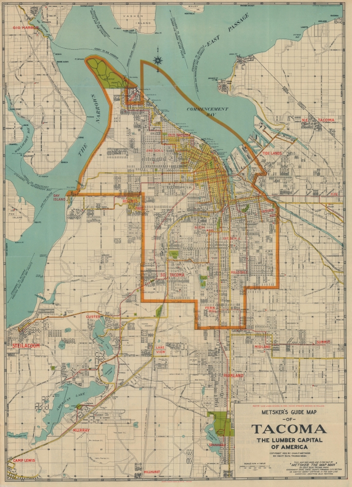
Metsker's Guide Map of Tacoma The Lumber Capital of America.
1923 (dated) 26.25 x 18.75 in (66.675 x 47.625 cm) 1 : 42240
1923 (dated) 26.25 x 18.75 in (66.675 x 47.625 cm) 1 : 42240
Description
This is a 1923 Charles Metsker city plan or map of Tacoma, Washington, and its environs. The map celebrates Tacoma's rise as the Lumber Capital of the Pacific Northwest. It is also significant for its illustration of the ephemeral Tacoma streetcar system and the city's fast transition to paved automobile roads.
A Closer Look
Coverage embraces from Gig Harbor to Hillhurst with major roads illustrated. Yellow highlighting represents the few paved roads, a stark reminder of how difficult individual travel was in the 1920s, even in a city as large as Tacoma. Nonetheless, we see an emerging public transportation system in the form of red-highlighted streetcar lines connecting Tacoma with its suburbs. The wharves along Commencement Bay are identified by the operating company, including numerous lumber companies, the city dock, and a few ferry landings. Ferry and steamer routes from Tacoma are also noted. A bold orange line marks Tacoma's official city limits.The Lumber Capital
In the 1920s, Tacoma, Washington, emerged as a pivotal lumber capital, harnessing its strategic location on Puget Sound to become a nexus for the timber industry in the Pacific Northwest. This era saw the city's waterfront dotted with mills and warehouses, buzzing with activity as timber, harvested from the surrounding forests, were processed, stored, and shipped. Tacoma's rail connections and deep-water port facilitated lumber exports to global markets, including to Asia, bolstering the local economy and shaping the city's identity.Streetcars in Tacoma
In the late 19th and early 20th century, streetcars were the key form of transportation in many American cities, and Tacoma was not an exception. The first streetcar lines (streetcars pulled by horses) opened in Tacoma in 1888 along Pacific Avenue and Tacoma Avenue. By the early 1910s, Tacoma had 125 miles of streetcar trackage and nearly 30 lines. These included many electrified lines, along with an electrified interurban line to Seattle. The Tacoma Railway and Power Company served around 30,000,000 passengers a year at its peak. However, as in most other American cities, the rise of private automobiles caused a precipitous drop in ridership. The last streetcar in Tacoma ran on June 11, 1938. Since the mid-1990s, public rail in Tacoma and Seattle has been on the rise, with Sound Transit and Tacoma Link both reviving enthusiasm for streetcars.Publication History and Census
This map was created and published by Charles F. Metsker in 1923. We note six cataloged examples in OCLC: Yale University, the University of Michigan, the University of Chicago, the University of Illinois Urbana-Champaign, Stanford University, and the University of Minnesota, Twin Cities.Cartographer
Charles Frederick Metsker (December 5, 1881 - October 6, 1966) was an American cartographer and publisher. Born in Douglas County, Kansas, Metsker's family moved to Winlock, Washington, in 1900. Metsker began publishing maps in 1901 in Tacoma, Washington. By the 1920s he was advertising as 'Metsker the Map Man' in Washington and Oregon newspapers. He opened a brick and mortar store in 1950 in Seattle and sold Township maps and atlases and County maps. He married Minnie B. Clevenger (1888 - 19xx) on May 11, 1905, with whom he had two children. They divorced sometime between 1910 and 1920. He married Elizabeth F. Metsker (1899 - 1982) on November 6, 1922, with whom he had a daughter. He retired in 1948 when he turned the business over to his son. He died in McMinnville, Oregon, at the age of 84. Metsker Maps joined forces with the Kroll Map Company, another Seattle-based mapmaker, in 1980. Metsker Maps continues to operate in Seattle to this day, where they can be visited at the Pike Place Market in the Sanitary Market Building. More by this mapmaker...
Condition
Good. Wear along original fold lines. Verso repairs to fold separations. Closed margin tears professionally repaired on verso. Slight loss at a few fold intersections.
References
OCLC 645695377.