This item has been sold, but you can get on the Waitlist to be notified if another example becomes available, or purchase a digital scan.
1895 Nishumura Torjiro Map of Taiwan after Treaty of Shimonoseki
Taiwan-nishumuratorjiro-1895$977.50

Title
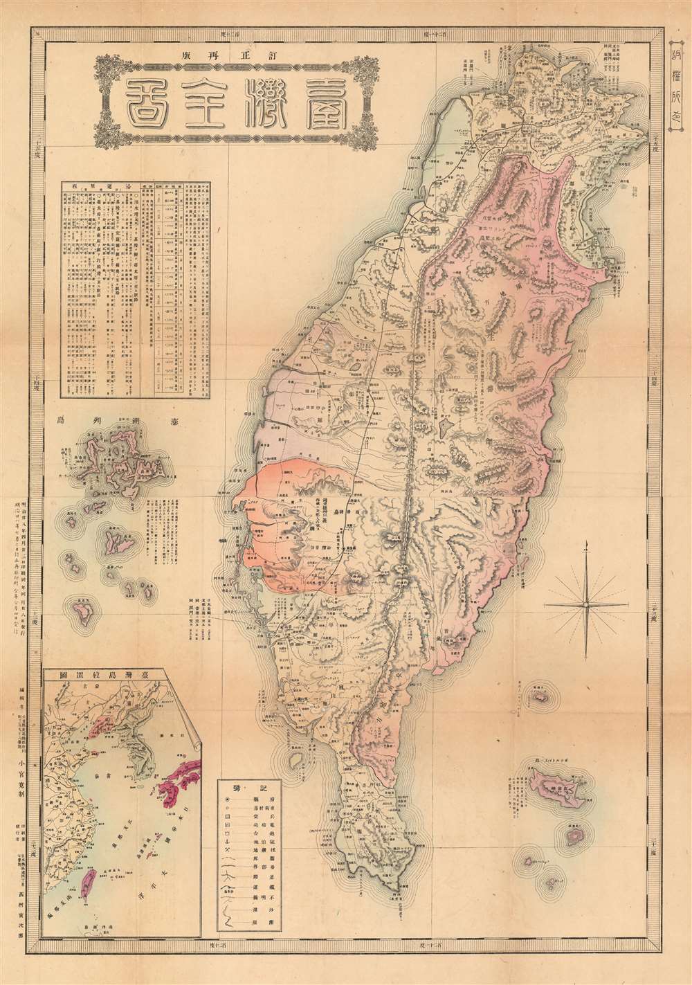
台灣全圖 / Complete Map of Taiwan.
1895 (dated) 29.5 x 20.5 in (74.93 x 52.07 cm) 1 : 600000
1895 (dated) 29.5 x 20.5 in (74.93 x 52.07 cm) 1 : 600000
Description
This is a rare Meiji 28 1895 map of Taiwan or Formosa issued shortly after the April 17 signing of the Treaty of Shimonoseki, which formally ended the First Sino-Japanese War (August 1, 1894 – April 17, 1895). The map covers all of Taiwan with a clear division between eastern and western territories. At the time western Formosa, or Taiwan (臺灣) was primarily Chinese, while Formosa east of the Central Mountain Range, Banchi (蕃地) consisted of unexplored indigenous tribal lands. The coverage extends to the Penghu Islands, or Pescadores, which were ceded to Japan as part of the treaty. In the upper right, an inset submap illustrates Taiwan in relation to Fujian China, from which it was governed under the Qing.
This map is part of a series of maps issued in 1895, both before and after the treaty, typically by private newspapers, book stores, and enterprising publishers, to capitalize on Japanese public interest in Taiwan. All are quite rare and significant in illustrating the events of this ephemeral period.
This map is part of a series of maps issued in 1895, both before and after the treaty, typically by private newspapers, book stores, and enterprising publishers, to capitalize on Japanese public interest in Taiwan. All are quite rare and significant in illustrating the events of this ephemeral period.
Publication History and Census
This map was issued in two editions. It was published by Nishimura Torajirō (西村天囚, 1865 - 1924) of the Asahi Shimbun, probabally the Tokyo office, and printed by Kansei Komiya. This first edition was printed April 23, 1895 and released on April 28. The second edition, as here, was printed on July 2, and distributed on July 4, 1895. We have been able to identify two other examples, one held at the National Diet Library, Japan, and another at the University of California, Berkeley.CartographerS
Nishimura Torajirō (September 12, 1865 - July 29,1924) (西村天囚) was a Japanese journalist, mapmaker, and publisher active in the late 19th and early 20th centuries. Torajirō was born in the city of Nishinoomote, Kagoshima Prefecture, on the Osumi Island of Tanegashima . He studied in the Tokyo Imperial University from 1880 (Meiji 13), graduating in 1887. He became a journalist in 1889, and took a job with the Osaka Asahi Shimbun in 1890. He was war correspondent during the Sino Japanese War and became Chief editor of the Tokyo branch of theOsaka Asahi Shimbun, the Tokyo Asahi Shimbun, shortly afterwards. He returned to the Osaka in 1902, becoming the Osaka Asahi Shimbun editorial advisor in 1914. In May of 1920 he was awarded an honorary Doctorate of Literature. He died four years later in 1924. More by this mapmaker...
The Asahi Shimbun (朝日新聞; January 25, 1879 – Present), translated Morning Sun Newspaper, is one of Japan's oldest and most venerable daily newspapers. The Asahi Shimbun began publication in Osaka on January 25, 1879 as a small-print, four-page illustrated paper. The paper was founded by Kimura Noboru (company president), Murayama Ryōhei (owner), and Tsuda Tei (managing editor). In 1888 the newspaper expanded with a branch in Tokyo and began issuing the Tokyo Asahi Shimbun. The the Osaka and Tokyo papers formally merged under a single imprint in 1940. Almost from its inception the newspaper was known for its liberal views. The Asahi Shimbun continues to publish from Osaka today. Learn More...
Condition
Very good. Minor toning on original fold lines with minor pinhole loss at fold intersections.
References
OCLC 683351001. University of California, Berkeley, Bd 3 SPEC-Map.