This item has been sold, but you can get on the Waitlist to be notified if another example becomes available, or purchase a digital scan.
1895 Nakamura Map of Formosa - a diplomatic poly to take over Taiwan!
TaiwanFormosa-nakamura-1895$4,750.00

Title
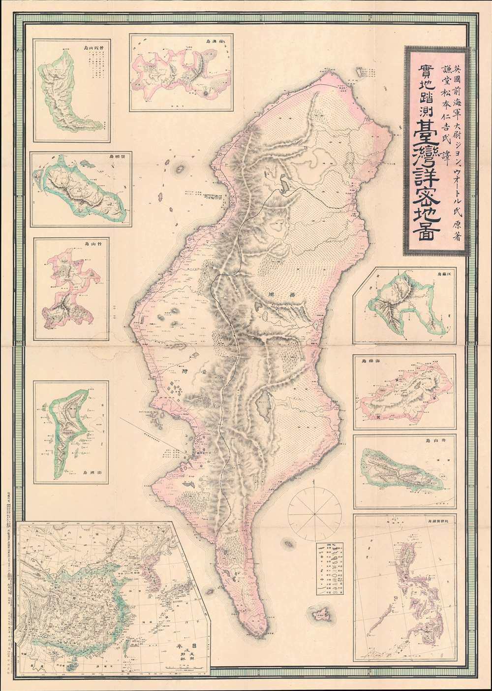
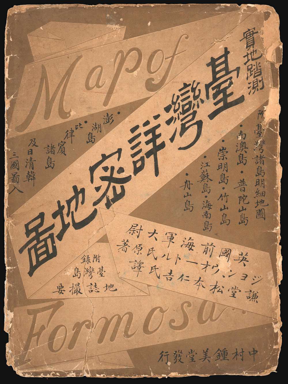
Detailed Map of Taiwan Field Survey. / 實地踏測台灣詳密地圖
1895 (dated) 40.5 x 29 in (102.87 x 73.66 cm) 1 : 438000
1895 (dated) 40.5 x 29 in (102.87 x 73.66 cm) 1 : 438000
Description
The first Japanese printed map of Taiwan and the birth certificate of Japanese-occupied Formosa. An extremely scarce and important 1895 or Meiji 28 large-scale map of Taiwan or Formosa issued near the end of the First Sino-Japanese War (August 1, 1894 - April 17, 1895), prior to the Treaty of Shimonoseki (April 17, 1895) and the Japanese invasion of Taiwan (May 29, 1895 - October 21, 1895). This map was likely a diplomatic and propaganda ploy prepared in anticipation of the Shimonoseki treaty negotiations, which included an Imperial Japanese demand for the Qing cession of Formosa/Taiwan. The map illustrates Taiwan/Formosa with a striking malformed shoreline and inaccurate interior, expanding Tainan and Hsinchu harbors into vast bites, adding corresponding projections to eastern Formosa, and shifting the Central mountains west. The deviations from established Formosa cartography, much of which was available to the Japanese, indicate an insidious intent - a diplomatic deception intended to diminish the territorial significance of Qing administered Formosa, then limited to the coastal lowlands west of the Central Mountain Range, while at the same time exaggerating the eastern ungoverned tribal regions and retaining the island's overall area.
There are several hints that this is not the case. First, Formosa is mapped correctly in the inset regional map int the lower left. Moreover, we are aware that the Japanese had accurate European maps of Taiwan collected for the Japanese Punitive Expedition of 1874. Second, the enlarged bays correspond to the largest and most important harbors then in Taiwan, Tainan and Hsinchu, the mismapping of which dually reduced the apparent size of western Formosa, which was predominantly Qing Chinese, and correspondingly increases the size of the 'uncivilized' tribal lands of eastern Formosa - long a thorn in the side of Qing provincial administrators.
While this map was printed near the end of the First Sino-Japanese War, in February of 1895, the powers had yet to sit down at the Shimonoseki negotiating tables, which did not occur until March 20, 1895. Nonetheless, Japanese interest in Formosa was well established. Near the endo the Sino-Japanese War, the U.S Minister in Beijing, Colonel Charles Denby, wrote 'China ceding Taiwan to Japan was sure to be a condition of any peace settlement.'
During the negotiation at Shimonoseki, the Qing were initially unwilling to surrender Taiwan, recognizing its strategic military and commercial potential. Nonetheless, they ultimately relented. One imagines the Japanese negotiator pulling out this map, proudly proclaiming that it was a 'new' survey made by a 'British Royal Navy' officer and so sure to be accurate. Then saying, 'Look how small the area of western Formosa under your control is! Look at these dangerous tribal lands in the mountains, who are always at war with you! We are doing you a favor…'
The Inaccuracies: Mistakes or Deceitful Propaganda?
The map is rife with errors and inaccuracies that are difficult to explain, especially when the inset regional map in the lower left presents a far more accurate picture of Taiwan/Formosa. We are also aware of c. 1874 manuscript maps collected by the Japanese that are far more accurate and detailed. Curiously, the errors are most pronounced on the historically well-mapped western or 'Chinese' side of the island. As previously noted, the cartographer exaggerates the size of Tainan and Hsinchu harbors, transforming them into vast bays, while at the same time mapping corresponding land projections on the eastern side of the island. Given that the western bays are mirrored by eastern projections, one might be tempted to assign this to a series of inaccurate measurements.There are several hints that this is not the case. First, Formosa is mapped correctly in the inset regional map int the lower left. Moreover, we are aware that the Japanese had accurate European maps of Taiwan collected for the Japanese Punitive Expedition of 1874. Second, the enlarged bays correspond to the largest and most important harbors then in Taiwan, Tainan and Hsinchu, the mismapping of which dually reduced the apparent size of western Formosa, which was predominantly Qing Chinese, and correspondingly increases the size of the 'uncivilized' tribal lands of eastern Formosa - long a thorn in the side of Qing provincial administrators.
While this map was printed near the end of the First Sino-Japanese War, in February of 1895, the powers had yet to sit down at the Shimonoseki negotiating tables, which did not occur until March 20, 1895. Nonetheless, Japanese interest in Formosa was well established. Near the endo the Sino-Japanese War, the U.S Minister in Beijing, Colonel Charles Denby, wrote 'China ceding Taiwan to Japan was sure to be a condition of any peace settlement.'
During the negotiation at Shimonoseki, the Qing were initially unwilling to surrender Taiwan, recognizing its strategic military and commercial potential. Nonetheless, they ultimately relented. One imagines the Japanese negotiator pulling out this map, proudly proclaiming that it was a 'new' survey made by a 'British Royal Navy' officer and so sure to be accurate. Then saying, 'Look how small the area of western Formosa under your control is! Look at these dangerous tribal lands in the mountains, who are always at war with you! We are doing you a favor…'
Japanese Occupation of Taiwan
Japan occupied Taiwan from 1895 to 1945. Japanese naval forces invaded Taiwan in May of 1895, after it was ceded to them by Treaty of Shimonoseki (April 17, 1895) at the end of the First Sino-Japanese War (1894 - 1895). The occupation of Taiwan fit into Imperial Japan's Nanshin-ron (南進論) or Southern Expansion Doctrine, which argued that Taiwan, Southeast Asia, and the Philippines were essential to Japan's economic and territorial growth. Katsura Taro (1747 - 1913), a Yamaguchi Samurai, wrote of Taiwan's significance, 'It is not only the most ideal location for expanding power to southern China, but also the islands of Southeast Asia.' Although there were some indigenous attempts at resistance and self-governance, including the founding of the 'Republic of Formosa', Asia's first republic, the Japanese were quickly able to suppress Formosan nationalism. In less than 6 months, Japanese naval forces achieved, with the arguable exception of the tribal central highlands, full control of the island. Taiwan was Japan's first major extraterritorial holding, and Imperial Japan worked diligently transform it into showpiece 'model colony.' Japan lavished resources on the island's economy, including public works, industrial development, and cultural Japanization. After an initial period of unrest, the Japanese were generally effective in Taiwan, where they were, for the most part, approved of by the Taiwanese, who appreciated the advanced technology and economic growth. Of course, the darker side of Imperial Japanese investment in Taiwan was its planned essential role in supporting Japanese military aggression in the Asia-Pacific.The Mysterious Source: John Walter / Water
Text on the map claims the cartography is copied from work done by a former British Royal Navy officer named John Walter or Water (ジョン・ウォートル), who supposedly surveyed Taiwan in 1894. We have been unable to trace Walter/Water or any survey work completed by this individual. Certainly, the British Royal Navy were active in the waters around Formosa from 1817, and had successfully compiled a respectable map of the coast by 1867, but there is no record of 'Walter,' or any variant thereof, associated with any of the survey teams. We did identify a marine engineer by the name of 'John Walker' active in the Japan trade in 1894, when he was involved with a shipwreck of the Japanese owned steamer Nagato Maru. Whoever, 'Walter' was, he apparently did not have access to the superior British maps and so compiled his own loose survey of the island, supposedly from firsthand surveying. This then was translated into Japanese by Nikichi Matsumoto (謙堂松本), another elusive figure. It is more likely that said 'Walter' never existed, and was merely a foil used by the Japanese publisher, Nakamura Yoshimatsu (中村芳松), to confer British legitimacy upon this map.The Inset Maps
From just under the title block, the insets are, clockwise,- 江蘇島 (Jiangsu Island - It is unclear where this is)
- 海南島 (Hainan Island - labeled as Hainan island, south oriented.)
- 舟山島 (Zhoushan Island, actually Zhuhhan, just south of Daishan Island - off the coast southeast of Shanghai, south oriented)
- 菲律賓群島 (Philippine Islands, north oriented)
- 澎湖島 (Penghu Island - supposedly, does not clearly resemble any of the Penghu Islands)
- 竹山島 (Zhushan Island - probably Xiaojaioshan, just south of Daishan Island - off the coast southeast of Shanghai, south oriented
- 崇山島 (Chongshan Island - unclear what this is meant to represent.)
- 普陀山島 (Putuoshan Island - identified as Putuoshan, but more closely resembles nearby Zhuijiajian Island, north oriented)
- 南澳島 (Nan'ao Island) - Small Island in Shantou County, directly west of Taiwan on China coast - oriented to the south.
Publication History and Census
This map was published by Nakamura Yoshimatsu (中村芳松) in Osaka, Japan on February 1, 1895 (Meiji 28) and released shortly thereafter on February 5. This map is rare. We are aware of one example at the National Diet Library, Tokyo and another in that Taiwan National Archives.Cartographer
Nakamura Yoshimatsu (中村芳松; fl. c. 1882 - 1906) was a major Japanese book and map publisher active in Osaka during the late 19th and early 20th centuries. The firm's output varied, but mostly consisted of maps, geographical texts, and works discussing or glorifying the military. More by this mapmaker...
Condition
Good. Wear on old fold lines. Some infill along original centerfold, not affecting printed cartography.
References
OCLC 675441082. National Taiwan History Museum 0000228540. Kyoto University Comprehensive Museum Collection. Keating, J. F., The Mapping of Taiwan: Desired Economies, Coveted Geographies, page 98.