This item has been sold, but you can get on the Waitlist to be notified if another example becomes available.
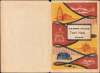
1973 Nirdosh Folding Map of Tamil Nadu, India
TamilNadu-nirdosh-1973$250.00


Title
Latest Guide Map Tamil Nadu Roads / Latest Guide Tamil Nadu Roads.
1973 (undated) 40 x 29.5 in (101.6 x 74.93 cm) 1 : 1000000
1973 (undated) 40 x 29.5 in (101.6 x 74.93 cm) 1 : 1000000
Description
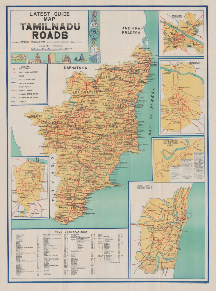
This is an unrecorded c. 1973 folding map of Tamil Nadu, India, produced by Nirdosh Publications. It reflects both the developing road network of India, a force for unification in post-independence India, and battles over national versus local identity, especially regarding national language policy.
The names of districts are written in large black text, while other city and town names are written in smaller text. Railways, both standard and meter gauge, are also recorded. (The state contained several meter gauge railways in its mountainous northern and western portions, but most were later converted to standard gauge, with the exception of the Nilgiri Mountain Railway, operated by a rack and pinion system.)
Five insets surround the map, displaying city plans of Tiruchirappalli, Madurai, Thanjavur, the Mount Road area of Madras (Chennai), and Madras writ large. A large table of distances is also included at the bottom. The decorative title cartouche includes illustrations relating to local culture and architecture, including the ancient Kapaleeshwarar Temple in Chennai and the Meenakshi Temple in Madurai.
A Closer Look
This colorful map covers the state of Tamil Nadu, formerly Madras State, with its borders following a 1956 reorganization of Indian states. As the title indicates, the main focus is on the state's road network, with main roads and highways highlighted with bold red lines and secondary roads traced with thinner red lines. Numbers along roads between cities note the distance of that stretch of road in kilometers. Some roads hint at future ambitions, including a highway to link Mandapam with Rameswaram on Pamban Island, which was ultimately completed in 1988, supplementing a rail bridge built in 1914 and recently replaced with a modern bridge (part of a potential future link across 'Adam's Bridge' with Sri Lanka).The names of districts are written in large black text, while other city and town names are written in smaller text. Railways, both standard and meter gauge, are also recorded. (The state contained several meter gauge railways in its mountainous northern and western portions, but most were later converted to standard gauge, with the exception of the Nilgiri Mountain Railway, operated by a rack and pinion system.)
Five insets surround the map, displaying city plans of Tiruchirappalli, Madurai, Thanjavur, the Mount Road area of Madras (Chennai), and Madras writ large. A large table of distances is also included at the bottom. The decorative title cartouche includes illustrations relating to local culture and architecture, including the ancient Kapaleeshwarar Temple in Chennai and the Meenakshi Temple in Madurai.
What's in a Name?
This map was produced in the context of linguistic battles over the use of English versus Hindi in placenames and public life. While the nation's highway network was deliberately developed by the Nehru government as a force for unification, language policies proved to be highly divisive. In the post-independence era, locals in Tamil Nadu, especially in Chennai (Madras), maintained a strong preference for English as a marker of their pronounced local identity, while the national government pushed for the use of Hindi instead. In fact, this battle had been ongoing since the 1930s, when the Indian National Congress mandated the teaching of Hindi in Indian schools. To Tamil speakers, this was seen as a draconian foreign imposition, and after three years of opposition from Madras and other non-Hindi-speaking regions, the requirement was withdrawn. However, the continuing push to make Hindi a national language has periodically caused tension between northern India, including Delhi, and non-Hindi-speaking regions. The implementation of the Official Languages Act of 1963, which was vague but was seen locally as a sly attempt to make Hindi the sole national language, caused widespread unrest in Tamil Nadu, including protests, riots, and even cases of self-immolation. The unrest led to the continued use of English alongside Hindi both in Tamil Nadu and throughout India, enshrined in a 1967 amendment to the Official Languages Act. However, the issue has continued to be a raw one in the decades since, especially regarding educational policy (the teaching of Hindi along with Tamil and English). Notably, the names Chennai and Tamil Nadu, as well as other place names that have reverted from their Anglicized versions, have proved uncontroversial since they are Tamil names (a handful of English names remain, including Wellington in Nilgiri District).Publication History and Census
This map was prepared by Nirdosh Publications and printed by Commercial Offset Press in Delhi. It is undated but cannot date to earlier than January 1969, when the name of Madras State was changed to Tamil Nadu. It also refers to the 'Sri Lanka High Commission' in the Mount Road area of Chennai; Ceylon officially changed its name to Sri Lanka in 1972. At the same time, the features present on the map and additional details, such as the presence of Air Ceylon (which ceased operations in 1979) in the Mount Road area, indicate a date in the early to mid-1970s. Moreover, existing catalog records suggest that both Nirdosh and the Commercial Offset Press were inactive by the mid-1970s. The map is unrecorded in institutional collections and has no known history on the market.CartographerS
Nirdosh Publications (fl. c. 1958 - c. 1975) was a map publishing house active in (New) Delhi in the 1960s and 1970s. They were originally based in the Jangpura Market and later moved to Shakapur. The firm primarily produced city plans of major Indian cities and road maps of the various Indian states. More by this mapmaker...
Commercial Offset Press (c. 1955 - 1973) was a printer of maps based in Karol Bagh, New Delhi. Their output primarily consisted of maps of various Indian cities and states in several formats, mostly folding maps for travelers and tourists, but also some large wall maps. Learn More...
Condition
Very good. Some verso reinforcement on old fold lines. Folds into original decorative paper binder.