This item has been sold, but you can get on the Waitlist to be notified if another example becomes available, or purchase a digital scan.
1915 U.S. Army Corps of Engineers Map of Tampa
Tampa-corpsengineers-1915$175.00

Title
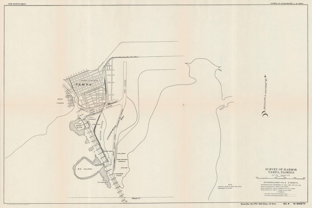
Survey of Harbor Tampa, Florida Sounding Sheet No. 8.
1915 (dated) 18 x 26.5 in (45.72 x 67.31 cm) 1 : 1500
1915 (dated) 18 x 26.5 in (45.72 x 67.31 cm) 1 : 1500
Description
A 1915 nautical chart and map of Tampa, Florida, produced by the U.S. Army Corps of Engineers. It demonstrates the dredging and widening of waterways leading to the city, which were essential to the growth of its economy, especially the shipping of phosphate and cigars which were locally produced.
A Closer Look
Coverage includes the city of Tampa with nearby islands and waterways. The Seddon Channel leading straight to the main part of the city is highlighted, with soundings provided along its length. This and other channels near Tampa had been subject to continuous deepening and widening projects by the Corps of Engineers in the preceding years. Navigational landmarks such as signal towers and the spire of the city's Catholic Church are also indicated. A legend and explanations appear at bottom-right below the title. The rail lines present belonged to the Atlantic Coast Line Railroad, but had originally been built by Henry B. Plant (in many respects the founder of modern Tampa) and were a key point in the 'Plant System' of rail lines throughout the Southeast.Engineering Tampa Bay
The U.S. Army Corps of Engineers undertook a series of projects near Tampa in the late 19th and early 20th century that helped to ensure the city's later development. Most notably, this included dredging work to deepen and widen Hillsborough Bay ('Hillsboro' in contemporary documents) to allow larger ships to reach Tampa from the Gulf of Mexico. Channels were also dug or widened along the Manatee River and other nearby waterways to facilitate the easy flow of water and allow more direct travel for ships. These efforts paid off handsomely when the Tampa region was discovered (in part by the Corps of Engineers) to be abundant in phosphate, an important ingredient in fertilizers which was shipped throughout the country. In the early 19th century, Tampa also became the center of America's cigar industry, similarly requiring robust port facilities to allow for continuous export.Publication History and Census
This map was produced by the U.S. Army Corps of Engineers between 1914 and 1915 and was printed by Norris Peters as part of a report to Congress titled Harbor at Tampa, Fla. Letter from the Secretary of War, transmitting with a letter from the Chief of Engineers, reports on preliminary examination and survey of harbor at Tampa, Fla. (64th Congress, House Doc. No. 1345). The map itself is not independently cataloged with any institution, while the entire report is held by a handful of institutions, though a precise census is difficult given the intermingling of digital and physical examples and the inconsistent cataloging of the individual report versus the bound collection of all House documents for the 64th Congress.Cartographer
Norris Peters (c. 1834 – July 15, 1889) was a Washington D.C. based photo-lithographer active in the late 18th and early 19th century whom Scientific American called 'one of Washington's most eccentric and mysterious figures.' Peters was born and educated in Pennsylvania. He relocated as a young man to Washington D.C. where he took work as an examiner for the United States Patent Office. During his work with the patent office he became fascinated with the emergent process of photolithography. In 1869 Peters secured substantial venture capital of about 100,000 USD from an unknown investor and founded The Norris Peters Company at 458 Pennsylvania Avenue. Their printing offices have been described as 'unequaled in this or any other country.' From these offices Peters pioneered the development of American photo-lithography. For nearly a generation he held a near monopoly on government photo-lithographic printing. Among their more notable contracts included numerous maps for congressional reports, maps of the U.S. Coast Survey, maps of the U.S. Geological Survey, Mexican currency for the State of Chihuahua, and the Official Gazette of the Patent Office. Peters also maintained an interesting social life and was a confidant to many of the most powerful figures in Congress. He was also a bon vivant known for being an excellent cook and hosting lavish dinners, the invitations to which were 'never declined'. Despite being socially active he never married and died a confirmed bachelor. Following Peters' death in 1889 his business was taken over by Henry Van Arsdale Parsell who administered it until his own death in 1901. The company then merged with Webb & Borcorselski, another D.C. lithography firm, and was renamed Webb & Borcorselski-Norris Peters. They continued to publish under this name well into the mid 20th century. More by this mapmaker...
Source
U.S. Army Corps of Engineers, Harbor at Tampa, Fla. Letter from the Secretary of War, transmitting with a letter from the Chief of Engineers, reports on preliminary examination and survey of harbor at Tampa, Fla., (64th Congress, House Doc. No. 1345) (Washington, D.C.: Norris Peters) 1915.
Condition
Very good. Light toning on old fold lines. Stable.
References
OCLC 2714820, 8933103.