This item has been sold, but you can get on the Waitlist to be notified if another example becomes available, or purchase a digital scan.
1915 U.S. Army Corps of Engineers Chart of Tampa Bay
TampaBay-corpsengineers-1915$175.00

Title
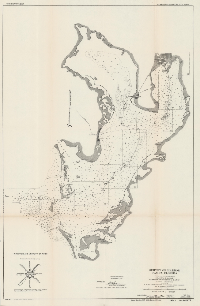
Survey of Harbor Tampa, Florida Index Sheet 1.
1915 (dated) 13.25 x 19.75 in (33.655 x 50.165 cm) 1 : 105000
1915 (dated) 13.25 x 19.75 in (33.655 x 50.165 cm) 1 : 105000
Description
A 1915 nautical map of Tampa Bay produced by the U.S. Army Corps of Engineers for a Congressional report. The Corps had undertaken multiple projects in this region in the preceding years which allowed Tampa to ship its economic products (phosphate and cigars, primarily) to distant ports, a major factor in the city's growth.
A Closer Look
The entirety of Tampa Bay is covered along with adjoining waterways, with sounding, keys, lights, buoys, and other navigational features marked throughout. Among them are a hospital and quarantine station on Mullet Key operated by the Marine Hospital Service that was tasked with inspecting foreign nationals arriving in Tampa and quarantining those who were ill (Tampa's population surged in the years before this map's publication as workers from Cuba and elsewhere arrived to work, mostly rolling cigars). On land, Tampa, Port Tampa, Palma Sola, and St. Petersburg are illustrated, while the Atlantic Coast Line Railroad and various coastal points are also noted. A diagram at bottom-left indicates the direction and velocity of winds. The present chart is an index to a series of maps, marked out with dashed line boxes, accompanying the same report, the eighth of which (also sold by us) covers Tampa itself and the Seddon Channel.Engineering Tampa Bay
The U.S. Army Corps of Engineers undertook a series of projects near Tampa in the late 19th and early 20th century that helped to ensure the city's later development. Most notably, this included dredging work to deepen and widen Hillsborough Bay ('Hillsboro' in contemporary documents) to allow larger ships to reach Tampa from the Gulf of Mexico. Channels were also dug or widened along the Manatee River and other nearby waterways to facilitate the easy flow of water and allow more direct travel for ships. These efforts paid off handsomely when the Tampa region was discovered (in part by the Corps of Engineers) to be abundant in phosphate, an important ingredient in fertilizers which was shipped from Tampa throughout the country. In the early 19th century, Tampa also became the center of America's cigar industry, similarly requiring robust port facilities to allow for continuous export.Publication History and Census
This map was prepared by 'C.F.P.' and produced by the U.S. Army Corps of Engineers between 1914 and 1915. It was printed by Norris Peters as part of a report to Congress titled Harbor at Tampa, Fla. Letter from the Secretary of War, transmitting with a letter from the Chief of Engineers, reports on preliminary examination and survey of harbor at Tampa, Fla. (64th Congress, House Doc. No. 1345). The map itself is not independently cataloged with any institution, while the entire report is held by a handful of institutions, though a precise census is difficult given the intermingling of digital and physical examples and the inconsistent cataloging of the individual report versus the bound collection of all House documents for the 64th Congress.Cartographer
Norris Peters (c. 1834 – July 15, 1889) was a Washington D.C. based photo-lithographer active in the late 18th and early 19th century whom Scientific American called 'one of Washington's most eccentric and mysterious figures.' Peters was born and educated in Pennsylvania. He relocated as a young man to Washington D.C. where he took work as an examiner for the United States Patent Office. During his work with the patent office he became fascinated with the emergent process of photolithography. In 1869 Peters secured substantial venture capital of about 100,000 USD from an unknown investor and founded The Norris Peters Company at 458 Pennsylvania Avenue. Their printing offices have been described as 'unequaled in this or any other country.' From these offices Peters pioneered the development of American photo-lithography. For nearly a generation he held a near monopoly on government photo-lithographic printing. Among their more notable contracts included numerous maps for congressional reports, maps of the U.S. Coast Survey, maps of the U.S. Geological Survey, Mexican currency for the State of Chihuahua, and the Official Gazette of the Patent Office. Peters also maintained an interesting social life and was a confidant to many of the most powerful figures in Congress. He was also a bon vivant known for being an excellent cook and hosting lavish dinners, the invitations to which were 'never declined'. Despite being socially active he never married and died a confirmed bachelor. Following Peters' death in 1889 his business was taken over by Henry Van Arsdale Parsell who administered it until his own death in 1901. The company then merged with Webb & Borcorselski, another D.C. lithography firm, and was renamed Webb & Borcorselski-Norris Peters. They continued to publish under this name well into the mid 20th century. More by this mapmaker...
Source
U.S. Army Corps of Engineers, Harbor at Tampa, Fla. Letter from the Secretary of War, transmitting with a letter from the Chief of Engineers, reports on preliminary examination and survey of harbor at Tampa, Fla., (64th Congress, House Doc. No. 1345) (Washington, D.C.: Norris Peters) 1915.
Condition
Very good. Light toning on old fold lines. Stable.
References
OCLC 2714820, 8933103.