1686 Dapper View of Tangier, Morocco
Tangier-dapper-1686$350.00

Title
Tanger.
1686 (undated) 10 x 12.75 in (25.4 x 32.385 cm)
1686 (undated) 10 x 12.75 in (25.4 x 32.385 cm)
Description
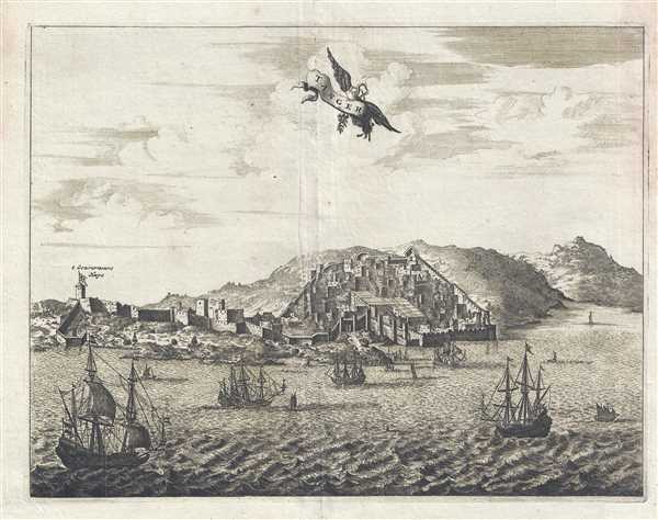
This is a 1686 Olfert Dapper view of Tangier. Depicted from the Mediterranean, the appears to ascend the mountains along the Moroccan coastline, with walls surrounding it for added protection. Several buildings are individually rendered, while others blend in with the rest of the city. Several large ocean-going vessels are illustrated in the Mediterranean, traversing what is today known as the Strait of Gibraltar. The only location labeled throughout the city is the Governor's House, which is situated on the left side of the view.
This view was produced by Olfert Dapper and published by in the French edition of Description of Africa entitled Description de L'Afrique and published in 1686.
This view was produced by Olfert Dapper and published by in the French edition of Description of Africa entitled Description de L'Afrique and published in 1686.
Cartographer
Olfert Dapper (1636 - December 29, 1689) was a Dutch geographer, polyglot, and historian. Born in Amsterdam, he attended the University of Utrecht, where he was registered as a student in 1658. Two years later he began signing doctor medicinæ, but there in no evidence that he ever received any medical training or education. Dapper published a five-volume book about the history of Amsterdam entitled, Historische Beschrijving der Stadt Amsterdam and in 1665 published a Dutch translation from the Greek of the Histories of Herodotus. His best-known work, Naukeurige Beschrijvingen der Afrikaensche gewesten (Description of Africa), was published in 1668 and subsequently published in English by John Ogilby in 1670 and in French in 1686. Although Dapper never traveled to Africa, he took advantage of numerous reports from adventurers in order to compile this authoritative work over the course of three years. More by this mapmaker...
Source
Dapper, O., Description de L'Afrique, Contenant Les Noms, la Situation et les Confins de toutes ses Parties, leurs Rivieres, lerus Villes et leurs Habitations, leurs Plants et leurs Animaux; les Mœurs, les Coûtumes, la Langue, les Richesses, la Religion, et le Gouvernement de ses Peuples. Avec Des Cartes des Etats, des Provinces et des Villes, et des Figures en taille-douce, qui representent les habits et les principales Ceremonies des Habitans, les Plantes et les Animaux les moins connus (Amsterdam) 1686.
Description of Africa (Naukeurige Beschrijvinge der Afrikaensche Gewesten in the original archaic Dutch), first published in 1668, is an enthographic book which describes Africa. Written by the geographer Olmert Dapper and published by Jacob Van Meurs in two Dutch editions in 1668 and 1676, this work is considered to be one of the foundational works of African studies. Over the course of three years, Dapper consults numerous reports concerning the history and geography of the continent (as it was understood by 17th century Europeans) and travelogues. It is said that Dapper relied heavily on the records of the Dutch West India Company, although none of the original reports have been located by historians. In Description of Africa, per the Fondation Dapper, Dapper, 'far from passing judgement on the societies described and by avoiding ethnocentric connotations, was the first to apply an interdisciplinary approach, adroitly combining geography, economics, politics, medicine, and a study of culture.' Dapper did not write a 'work of exotic curiosities, but a work for posterity.' Description of Africa was published in English by John Ogilby in 1670 and a German translation appeared the following year. A French translation of the work was published in 1686.
Condition
Very good. Even overall toning. Light soiling. Blank on verso.