
Dapper, Olfert

Olfert Dapper (1636 - December 29, 1689) was a Dutch geographer, polyglot, and historian. Born in Amsterdam, he attended the University of Utrecht, where he was registered as a student in 1658. Two years later he began signing doctor medicinæ, but there in no evidence that he ever received any medical training or education. Dapper published a five-volume book about the history of Amsterdam entitled, Historische Beschrijving der Stadt Amsterdam and in 1665 published a Dutch translation from the Greek of the Histories of Herodotus. His best-known work, Naukeurige Beschrijvingen der Afrikaensche gewesten (Description of Africa), was published in 1668 and subsequently published in English by John Ogilby in 1670 and in French in 1686. Although Dapper never traveled to Africa, he took advantage of numerous reports from adventurers in order to compile this authoritative work over the course of three years.
Piracy in China!
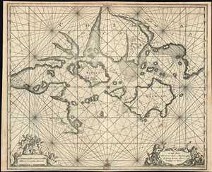
On these Islands whith are now becom a Kingdom used the famous Pyrates; Yquon and Kocksinga to Resort.
$1,200.00
Acquire
- Digital Map Information
- Suitable for large format printing
- DPI: 600
- File Size: 14.75 MB
- File Type: ZIP / TIFF
- ICC color profile embedded
- Delivered instantly via download link
This is a c. 1675 Olfert Dapper piracy map of Xiamen (Amoy), Kinmen (Quemoy), and the Fujian coast in southeastern China. With Xiamen just to the left of center, this map represents the most detailed mapping of the region by the end of the 17th century. Myriad rhumb lines crisscross the map, aiding in navigation, and numerous depth soundings appear as well - something absent in all previous printed maps of the region. Illustrations mark settlements on Xiamen and Kinmen and a bridge crosses the Anhay River, whose modern-day equivalent is unclear. As the map's title suggests, Xiamen and Kinmen were havens for the pirates known in the West as Iquan and Koxinga. (more details)
Beautifully Engraved 17th Century View of Damascus.
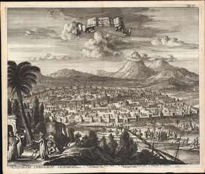
Damascus in Syrien Volgens des Afteeckening gedaen in 't Iaer 1668.
$750.00
Acquire
- Digital Map Information
- Suitable for large format printing
- Full resolution TIFF file
- ICC color profile embedded
- Delivered instantly via download link
This is a beautiful example of Jacob Meurs' engraved view of the Syrian city of Damascus, printed in 1681 as part of Olfert Dapper's history of Asia Minor and the Holy Land. The view is intended to portray the contemporaneous Muslim walled city; its mosques prominent. Some churches illustrated as well, though one of these, the Church of Saint Paul, is in ruins. In the foreground, noblemen in Ottoman styles converse as footmen lead their camels, replete with a covered chaise, towards the city. Before the walls of the city, the view presents a bustling scene of nobles, fishermen, cattle herders and soldiers. (more details)
Beautifully engraved map of the Cape Verde Islands.
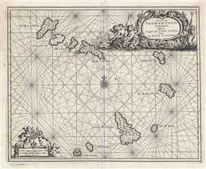
Insulæ Promontorii Virdis, Hispanis Issas de Cabo Verde, Belgis de Soute Eylanden.
$400.00
Acquire
- Digital Map Information
- Suitable for large format printing
- DPI: 300
- File Size: 4.95 MB
- File Type: ZIP / TIFF
- ICC color profile embedded
- Delivered instantly via download link
This is a 1686 Olfert Dapper map of the Cape Verde Islands, now known as Cabo Verde. The map depicts all 10 islands in the Cape Verde archipelago, which is located 350 miles off the coast of West Africa. Each of the islands is labeled, with rhumb lines included ... (more details)
West Africa served as the epicenter of the transatlantic slave trade in the 17th century.
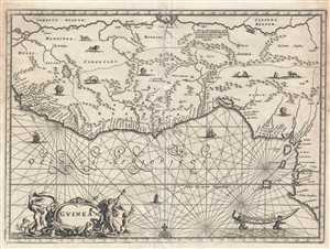
Guinea.
$550.00
Acquire
- Digital Map Information
- Suitable for large format printing
- DPI: 300
- File Size: 3.99 MB
- File Type: ZIP / TIFF
- ICC color profile embedded
- Delivered instantly via download link
This is a 1686 Olfert Dapper map of West Africa. The map depicts the region from approximately Mali and Sierra Leone along the Gulf of Guinea to Nigeria and Cameroon and from Mali and Niger to the Gulf of Gunea. Highly detailed, numerous locations are labeled ... (more details)
Uncommon map of west Africa with Slave Trade references.
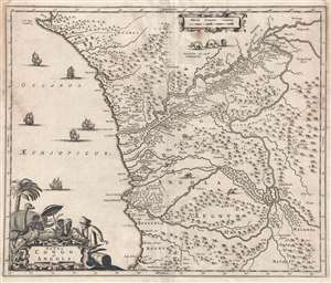
Regna Congo et Angola.
$350.00
Acquire
- Digital Map Information
- Suitable for large format printing
- DPI: 300
- File Size: 4.59 MB
- File Type: ZIP / TIFF
- ICC color profile embedded
- Delivered instantly via download link
This is a 1686 Olfert Dapper map of the western central Africa. The map depicts the Atlantic coast of Africa from approximately Gabon to Angola, with the inland portions of the map depicting parts of the Republic of the Congo and the Democratic Republic of ... (more details)
Alexandria: Ancient Glory, Ottoman Port.
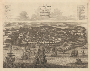
De Stadt Alexandrie of Scanderik. La Ville Alexandria ou Scanderik.
$350.00
Acquire
- Digital Map Information
- Suitable for large format printing
- Full resolution TIFF file
- ICC color profile embedded
- Delivered instantly via download link
This striking 1686 Olfert Dapper view of Alexandria, Egypt, presents the legendary Mediterranean port as it appeared to European readers in the late 17th century. Viewed dramatically from the sea, the fortified city spreads across the horizon while an animated harbor crowded with sailing vessels dominates the foreground. The image combines contemporary Alexandria with reminders of its celebrated ancient and Christian past, reflecting the enduring European fascination with a city once home to the Ptolemies, the Great Library, and the Pharos of Alexandria. (more details)
Illustrates the Giza Pyramids and the Great Sphinx.
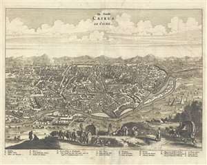
De Stadt Cairus. Le Caire.
$500.00
Acquire
- Digital Map Information
- Suitable for large format printing
- DPI: 300
- File Size: 6.25 MB
- File Type: ZIP / TIFF
- ICC color profile embedded
- Delivered instantly via download link
This is a 1686 Olfert Dapper view of Cairo, Egypt. The view depicts Cairo from a hill on the opposite side of the Nile overlooking the city. Cairo stretches out below the viewer nearly to the horizon. Individual buildings are illustrated, and eleven ... (more details)
A prominent North African trading port for French merchants during the 17th century.
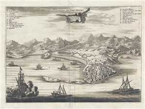
De Stadt Gigeri. La Ville Gegery.
$200.00
Acquire
- Digital Map Information
- Suitable for large format printing
- DPI: 300
- File Size: 4.41 MB
- File Type: ZIP / TIFF
- ICC color profile embedded
- Delivered instantly via download link
This is a 1686 Olfert Dapper view of Gigeri (Gegery), Algeria. The view depicts the city from the Mediterranean Sea, as the city was known to sit along the coastline without stretching very far inland. The city walls and individual buildings are ... (more details)
A beautifully engraved view of a wonderful North African city.
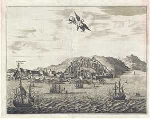
Tanger.
$350.00
Acquire
- Digital Map Information
- Suitable for large format printing
- DPI: 300
- File Size: 4.12 MB
- File Type: ZIP / TIFF
- ICC color profile embedded
- Delivered instantly via download link
This is a 1686 Olfert Dapper view of Tangier. Depicted from the Mediterranean, the appears to ascend the mountains along the Moroccan coastline, with walls surrounding it for added protection. Several buildings are individually rendered, while ... (more details)