This item has been sold, but you can get on the Waitlist to be notified if another example becomes available, or purchase a digital scan.
1574 Munster / Ptolemy Map of Ceylon, Sri Lanka, or Tapobrana
Tapobrana-munster-1574$225.00

Title
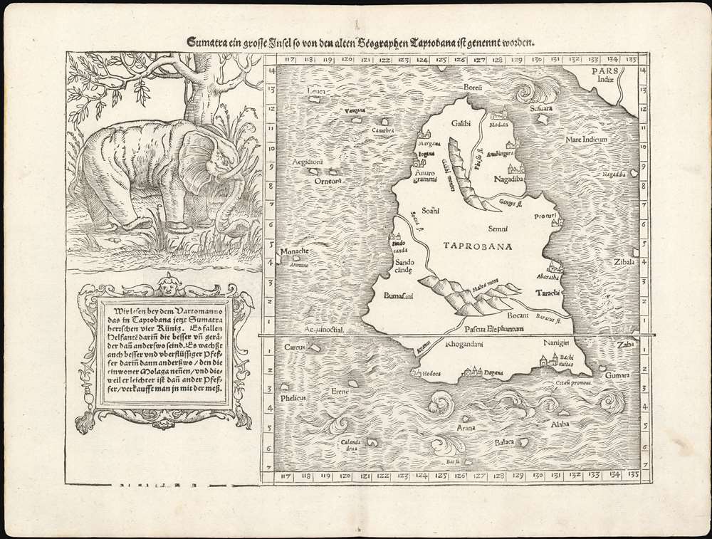
Sumatra Ein Grosse Insel, So Von Den Alten Geographen Taprobana, Ist Genent Worden.
1574 (undated) 10.5 x 14 in (26.67 x 35.56 cm) 1 : 2700000
1574 (undated) 10.5 x 14 in (26.67 x 35.56 cm) 1 : 2700000
Description
This is Sebastian Münster's 1574 map of Sumatra - using the Ptolemaic model for the map of Taprobana, which earlier mapmakers typically conflated with Sri Lanka. The map is oriented to the north and includes all of ‘Taprobana’ with a nineteen surrounding islands. The mainland of the appears above and to the right, which would correspond to the Malay peninsula were the map correctly identified with Sumatra, although this map roughly identifies to Sri Lanka's tear shape. To the left of the map is a naturalistic illustration of an elephant and ten lines of text describing the pepper trade - explicitly identifying the island as Sumatra. In doing so, Münster is differentiating himself from earlier cartographers whose versions of this map reproduced Ptolemy's map by rote - though he adds no new specific data to the map, his innovation is in the application of a specific modern interpretation of the ancient geographical data.
What is Tapobrana?
The first mention of Tapobrana is in the Geographia of Claudius Ptolemy. Today, Ptolemy's Taprobana is considered by some scholars to be entirely mythological and by others to be a wild misinterpretation of either Sumatra or Sri Lanka. Whatever the case may be, the island was mentioned by Marco Polo, who describes is as an enormous landmass:It has a circumference of some 2400 miles. And I assure you that it used to be bigger than this. For it was once as much as 3500 miles, as appears in the mariners' charts of this sea. But the north wind blows so strongly in these parts that is has submerged a great part of this island under the sea.This led many early cartographers to over-map the island, exaggerating its size and importance. To give this map some scale, the line running horizontally through the center of this map is the Equator (Aequinoctial), meaning that Munster's Taprobana extends from the southern tip of the subcontinent south well beyond the equator - a factor that would make it nearly as large as India!
Munster's Elephant
Munster issued two maps with a prominent elephant engraving, the present map and his map of Sumatra. It is no mistake that both maps are associated with the Ptolemaic island of Tapobrana, the pepper trade, and yes, elephants. Munster's elephant first appeared in this 1540 edition of this map, to the left of Tapobrana / Ceylon. In 1588 Sebastian Petri made a new map, reassigning the historic Tapobrana to Sumatra, and accordingly transferring the elephant to the new Sumatra woodcut plate. Munster's elephant is both innovative and unique. Unlike most 16th century representations of wildlife, Munster's elephant is presented within the context of its natural habitat, surrounded by jungle trees and other rich foliage. Other cartographers, including Girolamo Ruscelli (1500 - 1566) and Giocomo Gastaldi (c. 1500 - October, 1566) followed his example on their own Tapobrana maps.Publication History and Census
This map first appeared in Sebastian Münster's 1540 Geographia Universalis, and was reissued in all six editions of that work. The present example is from the 1574 Petri edition of Münster's work of modern geography, Cosmographia : Beschreibung aller Lender . Oddly, it appears in only six German editions of the many that were produced of Münster's influential work. Consequently it is one of the scarcest of his double-page maps. It was replaced by a completely new block in all editions from 1588 onwards.CartographerS
Sebastian Münster (January 20, 1488 - May 26, 1552), was a German cartographer, cosmographer, Hebrew scholar and humanist. He was born at Ingelheim near Mainz, the son of Andreas Munster. He completed his studies at the Eberhard-Karls-Universität Tübingen in 1518, after which he was appointed to the University of Basel in 1527. As Professor of Hebrew, he edited the Hebrew Bible, accompanied by a Latin translation. In 1540 he published a Latin edition of Ptolemy's Geographia, which presented the ancient cartographer's 2nd century geographical data supplemented systematically with maps of the modern world. This was followed by what can be considered his principal work, the Cosmographia. First issued in 1544, this was the earliest German description of the modern world. It would become the go-to book for any literate layperson who wished to know about anywhere that was further than a day's journey from home. In preparation for his work on Cosmographia, Münster reached out to humanists around Europe and especially within the Holy Roman Empire, enlisting colleagues to provide him with up-to-date maps and views of their countries and cities, with the result that the book contains a disproportionate number of maps providing the first modern depictions of the areas they depict. Münster, as a religious man, was not producing a travel guide. Just as his work in ancient languages was intended to provide his students with as direct a connection as possible to scriptural revelation, his object in producing Cosmographia was to provide the reader with a description of all of creation: a further means of gaining revelation. The book, unsurprisingly, proved popular and was reissued in numerous editions and languages including Latin, French, Italian, and Czech. The last German edition was published in 1628, long after Münster's death of the plague in 1552. Cosmographia was one of the most successful and popular books of the 16th century, passing through 24 editions between 1544 and 1628. This success was due in part to its fascinating woodcuts (some by Hans Holbein the Younger, Urs Graf, Hans Rudolph Manuel Deutsch, and David Kandel). Münster's work was highly influential in reviving classical geography in 16th century Europe, and providing the intellectual foundations for the production of later compilations of cartographic work, such as Ortelius' Theatrum Orbis Terrarum Münster's output includes a small format 1536 map of Europe; the 1532 Grynaeus map of the world is also attributed to him. His non-geographical output includes Dictionarium trilingue in Latin, Greek, and Hebrew, and his 1537 Hebrew Gospel of Matthew. Most of Munster's work was published by his stepson, Heinrich Petri (Henricus Petrus), and his son Sebastian Henric Petri. More by this mapmaker...
Heinrich Petri (1508 - 1579) and his son Sebastian Henric Petri (1545 – 1627) were printers based in Basel, Switzerland. Heinrich was the son of the printer Adam Petri and Anna Selber. After Adam died in 1527, Anna married the humanist and geographer Sebastian Münster - one of Adam's collaborators. Sebastian contracted his stepson, Henricus Petri (Petrus), to print editions of his wildly popular Cosmographia. Later Petri, brought his son, Sebastian Henric Petri, into the family business. Their firm was known as the Officina Henricpetrina. In addition to the Cosmographia, they also published a number of other seminal works including the 1566 second edition of Nicolaus Copernicus's De Revolutionibus Orbium Coelestium and Georg Joachim Rheticus's Narratio. Learn More...
Claudius Ptolemy (83 - 161 AD) is considered to be the father of cartography. A native of Alexandria living at the height of the Roman Empire, Ptolemy was renowned as a student of Astronomy and Geography. His work as an astronomer, as published in his Almagest, held considerable influence over western thought until Isaac Newton. His cartographic influence remains to this day. Ptolemy was the first to introduce projection techniques and to publish an atlas, the Geographiae. Ptolemy based his geographical and historical information on the "Geographiae" of Strabo, the cartographic materials assembled by Marinus of Tyre, and contemporary accounts provided by the many traders and navigators passing through Alexandria. Ptolemy's Geographiae was a groundbreaking achievement far in advance of any known pre-existent cartography, not for any accuracy in its data, but in his method. His projection of a conic portion of the globe on a grid, and his meticulous tabulation of the known cities and geographical features of his world, allowed scholars for the first time to produce a mathematical model of the world's surface. In this, Ptolemy's work provided the foundation for all mapmaking to follow. His errors in the estimation of the size of the globe (more than twenty percent too small) resulted in Columbus's fateful expedition to India in 1492.
Ptolemy's text was lost to Western Europe in the middle ages, but survived in the Arab world and was passed along to the Greek world. Although the original text almost certainly did not include maps, the instructions contained in the text of Ptolemy's Geographiae allowed the execution of such maps. When vellum and paper books became available, manuscript examples of Ptolemy began to include maps. The earliest known manuscript Geographias survive from the fourteenth century; of Ptolemies that have come down to us today are based upon the manuscript editions produced in the mid 15th century by Donnus Nicolaus Germanus, who provided the basis for all but one of the printed fifteenth century editions of the work. Learn More...
Source
Munster, S. Cosmographey oder beschreibung aller Länder (Basel: Petri) 1574.
The Cosmographia Universalis, one of the greatest geographical and historical works of the 16th century, 'taught nearly three generations of laymen most of what they knew about the world beyond their native places' (Strauss). Filled with maps, views, and rich descriptions of places throughout Europe and beyond, it was the best general source of geographical information until the advent of Ortelius' Theatrum. It was first issued by Sebastian Munster (1488 - 1552) in its 1544 German edition, and stayed in print long after its author's death in thirty five editions, and in five languages. (Of these, the 1550 and 1552 editions are widely regarded as the most complete and truest to the author's intentions: thereafter, later editors continued to add to the work's text; editions from 1588 onwards employed an entirely different set of maps produced on Ortelius' model.) Munster's goal, initially, was to rally his homeland's humanists and scholars to produce a new map of Germany in order to 'see what kind of a land our ancestors conquered for their home... bring honor to our country and place its beauties in the clear light of day.' Munster's project quickly expanded to cover the known world in its scope to produce a 'sufficiently large volume, in which I touch upon the foundation of all nations and kingdoms, their peculiarities, rivers, mountains, customs of men, royal successions, origins of the more important cities, succinct histories, religions, characteristics and fertility of lands... in Germany, however, I tarry a little longer'.
Munster's methodology in Cosmographia is notable in particular for his dedication to providing his readers with direct access to firsthand reports of his subjects wherever possible. Many of the maps were the result of his own surveys; others, the fruit of an indefatigable letter writing campaign to scholars, churchmen and princes throughout Europe, amicably badgering them for maps, views, and detailed descriptions of their lands. For lands further afield than his letters could reach, Munster relied on the best that the authorities of northern European scholarship could offer: he was well familiar with the work of Waldseemuller and other geographers of the early 16th century, and was well connected with the best geographers of his own generation. A disproportionate number of the maps of Cosmographia show contemporary geographical knowledge of the their respective areas for the very first time: The first map to show the continents of the Western Hemisphere; the first map to focus on the continent of Asia; the first modern map to name the Pacific Ocean; the first map to use a key; the first modern map of the British Isles and so on. Even in cases where earlier maps exist, Munster's works very often remain the earliest such acquirable by the collector.
Munster's methodology in Cosmographia is notable in particular for his dedication to providing his readers with direct access to firsthand reports of his subjects wherever possible. Many of the maps were the result of his own surveys; others, the fruit of an indefatigable letter writing campaign to scholars, churchmen and princes throughout Europe, amicably badgering them for maps, views, and detailed descriptions of their lands. For lands further afield than his letters could reach, Munster relied on the best that the authorities of northern European scholarship could offer: he was well familiar with the work of Waldseemuller and other geographers of the early 16th century, and was well connected with the best geographers of his own generation. A disproportionate number of the maps of Cosmographia show contemporary geographical knowledge of the their respective areas for the very first time: The first map to show the continents of the Western Hemisphere; the first map to focus on the continent of Asia; the first modern map to name the Pacific Ocean; the first map to use a key; the first modern map of the British Isles and so on. Even in cases where earlier maps exist, Munster's works very often remain the earliest such acquirable by the collector.
Condition
Very good. Minor centerfold wear. Minor margin repair on verso.
References
OCLC 163145839.