This item has been sold, but you can get on the Waitlist to be notified if another example becomes available, or purchase a digital scan.
1645 Blaeu Map of Northeast Asia: Siberia, Mongolia, Tartary, China, Central Asia
Tartaria-blaeu-1645$350.00

Title
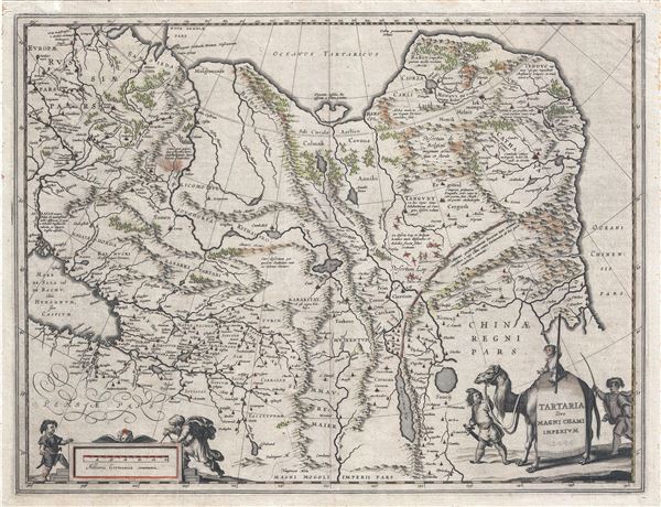
Tartaria sive Magni Chami Imperium.
1645 (undated) 15.5 x 20 in (39.37 x 50.8 cm) 1 : 19232000
1645 (undated) 15.5 x 20 in (39.37 x 50.8 cm) 1 : 19232000
Description
A fine c. 1645 map of northeast Asia (Siberia or Tartary) by J. Blaeu. The map covers from the Caspian Sea and the Volga River east as far as the China Sea and the city of Xanadu. It extends north to Nova Zembla and south to the Upper Ganges River. When Blaeu drew this map this part of the world was almost entirely unknown. Blaeu relied on the journals of Marco Polo to compile most of the map. Devils and dragons frolic in the Lop Nor and far to the north the summer seat of Kublai Khan's Yuan Empire Xanadu (Shangdu) is noted. The Great Wall of China appears prominently. Further west, the Geography becomes more stable with recognizable Silk Route centers such as Samarkand clearly identified. The title is set into a saddle blanket on the back of a dromedary. Mountains and forests are rendered pictorially. This map is distinguished from Jansson's very similar map by Blaeu's inclusion of degrees of longitude along the borders and meridians crossing the map. Issued in the 1645 German language edition of Blaeu's Atlas Major.
Cartographer
Joan (Johannes) Blaeu (September 23, 1596 - December 21, 1673) was a Dutch cartographer active in the 17th century. Joan was the son of Willem Janszoon Blaeu, founder of the Blaeu firm. Like his father Willem, Johannes was born in Alkmaar, North Holland. He studied Law, attaining a doctorate, before moving to Amsterdam to join the family mapmaking business. In 1633, Willem arranged for Johannes to take over Hessel Gerritsz's position as the official chartmaker of the Dutch East India Company, although little is known of his work for that organization, which was by contract and oath secretive. What is known is his work supplying the fabulously wealthy VOC with charts was exceedingly profitable. Where other cartographers often fell into financial ruin, the Blaeu firm thrived. It was most likely those profits that allowed the firm to publish the Theatrum Orbis Terrarum, sive, Atlas Novus, their most significant and best-known publication. When Willem Blaeu died in 1638, Johannes, along with his brother Cornelius Blaeu (1616 - 1648) took over the management of the Blaeu firm. In 1662, Joan and Cornelius produced a vastly expanded and updated work, the Atlas Maior, whose handful of editions ranged from 9 to an astonishing 12 volumes. Under the brothers' capable management, the firm continued to prosper until the 1672 Great Amsterdam Fire destroyed their offices and most of their printing plates. Johannes Blaeu, witnessing the destruction of his life's work, died in despondence the following year. He is buried in the Dutch Reformist cemetery of Westerkerk. Johannes Blaeu was survived by his son, also Johannes but commonly called Joan II, who inherited the family's VOC contract, for whom he compiled maps until 1712. More by this mapmaker...
Source
Blaeu, W., Atlas Major, (Amsterdam: Blaeu) 1645.
In 1662 Joan Blaeu published his masterwork, which has been described as 'the greatest and finest atlas ever published' (Verwey, 1952): his monumental, eleven-volume Atlas Maior. This contained nearly six hundred maps, more than two hundred in excess of the Blaeus' mainstay the Atlas Novus. The former work already being renowned for the quality and beauty of its maps, Blaeu not only added copious material but improved the sophistication of his work: many of the newly-added maps utilized larger-sized presses and sheets, and the artistry applied to the engravings was often far superior to that of the earlier maps in the atlas - many of which by now were 30, and some more than 50 years old. Blaeu's Atlas Maior was published from 1662 to 1672, consisting of some 594 maps compiled into upwards of 9 volumes with some editions containing as many as 12 volumes. This triumphant work's publishing life was cut violently short when, in 1672, the Blaeu's mammoth workshop was destroyed by fire; surviving stock would be sold at auction between 1674 and 1677, occasionally appearing under the imprint of later Dutch printers such as Pieter Schenk and Pieter Mortier. The maps added to the Atlas Maior, owing to their tragically short publishing life, are among the hardest-to-find of the Blaeu maps.
Condition
Very good. Back with fine japanese tissue. German text on verso. Minor discoloration upper left quadrant.
References
Koeman/V.d.Krogt, Atlantes Neerlandici, Vol.2, 112.2. OCLC: 224308027.