1680 De Wit map of Tartaria and China
Tartaria-wit-1680$750.00

Title
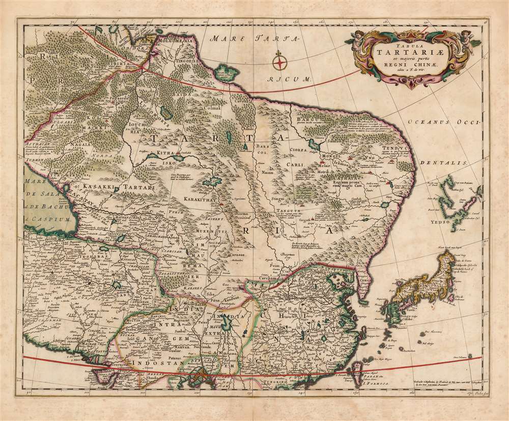
Tabula Tartariae et majoris partis Regni Chinae edita a F. de Wit.
1680 (undated) 17.25 x 21.5 in (43.815 x 54.61 cm) 1 : 15000000
1680 (undated) 17.25 x 21.5 in (43.815 x 54.61 cm) 1 : 15000000
Description
This beautifully engraved and colored map is Frederick de Wit's 1680 map of Central Asia and the Far East, including Persia, China, Japan and Siberia. It reaches from the eastern Caspian Sea to the Pacific, and from the mouth of the Ganges in the south to the mouth of the Ob in Siberia. This represented the state of the art of Dutch cartography of northeastern Asia prior to the groundbreaking map of Nicolaas Witsen. The treatment of Japan and Yedso reflects the journey of Maarten Gerritsz Vries and the northeastern bulge evident on the maps of Blaeu and Jansson has been truncated here. The regions of central Asia are replete with descriptive texts, some of which were retained from the 15th century maps of Fra Mauro, and even from the narrative of Marco Polo. These focus particularly on the empire of the Grand Khan, and on various putative Christian kingdoms. The Great Wall of China is depicted.
Apocryphal Lake Chiamay
The mythical Lake of Chiamay, or Chiang Mai, appears at the south of the map, roughly in what is today Assam, India. Early cartographers postulated that such a lake must exist to source the four important Southeast Asian river systems: the Irrawaddy, the Dharla, the Chao Phraya, and the Brahmaputra. This lake began to appear on maps of Asia as early as the 16th century and persisted well into the mid-18th century. Its origins are unknown but may come from a lost 16th century geography prepared by the Portuguese scholar Joao de Barros. The map is embellished with a lovely strapwork cartouche flanked with putti, but it is not abundantly decorated. This stage of Dutch mapmaking began to strip away ornament in favor of detail, as more of the latter became available for presentation.Publication History and Census
This map was engraved for Frederick de Wit by Jan Lhuillier as early as 1662. It appeared in De Wit's atlas in this form until perhaps 1688. After 1689 the map's title was changed to indicate De Wit's receipt of a privilege. At this point Lhuillier's imprint was effaced, possibly to prevent any legal confusion over to whom the privilege had been granted. The present example, lacking any privilege, was certainly printed prior to 1688. The sharpness of the image suggests an early strike. In various editions this map is well represented in institutional collections.Cartographer
Frederik de Wit (1629 - 1706) was a Dutch Golden Age cartographer active in the second half of the 17th and the early 18th centuries. De Wit was born of middle class Protestant stock in the western Netherlandish town of Gouda. He relocated to Amsterdam sometime before 1648, where he worked under Willem Blaeu. His first attributed engraved map, a plan of Haarlem for Antonius Sanderus' Flandria Illustrata, was issued around this time. He struck out on his own in 1654. The first chart that De Wit personally both drew and engraved was most likely his 1659 map of Denmark, REGNI DANIÆ Accuratissima delineatio Perfeckte Kaerte van ‘t CONJNCKRYCK DENEMARCKEN. His great wall map of the world and most famous work, Nova Totius Terrarum Orbis Tabula appeared one year later. Following the publication of his wall map De Wit quickly rose in prominence as a both cartographer and engraver. He married Maria van der Way in 1661 and through her became a citizen of Amsterdam in 1662. Around this time he also published his first major atlas, a composite production ranging in size from 17 to over 150 maps and charts. Other atlases and individual maps followed. In 1689 De Wit was granted a 15 year Privilege by the Dutch States General. (An early copyright that protected the recipient's rights to print and publish.) He was recognized with the honorific 'Good Citizen' in 1694. De Wit died in 1706 after which his wife Maria continued publishing his maps until about 1710. De Wit's son, Franciscus, had no interest in the map trade, instead choosing to prosper as a stockfish merchant. On her own retirement, Maria sold most De Wit maps and plates at a public auction. Most were acquired by Pieter Mortier and laid the groundwork for the 1721 rise of Covens and Mortier, the largest Dutch cartographic publishing house of the 18th century. More by this mapmaker...
Source
De Wit, F., Atlas Tot Amsterdam, Bij Frederick de Wit in de Calverstraet bij den Dam inde Witte Paskaert, (Amsterdam: De Wit) 1680.
Condition
Very good. Marginal mends at centerfold. Some light spotting, superb original color.
References
OCLC 64025500. Rumsey 12220.072.