
This item below is out of stock, but another example (left) is available. To view the available item, click "Details."
Details
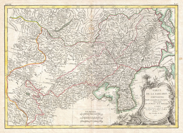
1771 Bonne Map of China, Mongolia, Manchuria and Korea (Corea)
1771 (dated) $350.00
1770 Bonne Map of Chinese Tartary, Mongolia, Manchuria and Korea (Corea)
TartarieChine-bonne-1770$175.00

Title
Carte deLa Tartarie Chinoise.
1771 (dated) 12 x 17 in (30.48 x 43.18 cm)
1771 (dated) 12 x 17 in (30.48 x 43.18 cm)
Description
A beautiful example of Rigobert Bonne's 1770 decorative map of Chinese Tartary. Covers from the Lop Nor region eastward to Korea, Manchuria, Sakalin and Jeso-Gasima (Hokkaido). Includes both Inner Mongolia and Outer Mongolia. Extends north to include Lake Baikal. Names numerous towns, cities and river systems. Shows the Great Wall of China. At the far eastern extreme of this map Jeso-Gasimia, or Hokkaido, is mapped speculatively along its northern shore. The island of Sahalien (or Sakhalin) also appears with erroneous shores. A decorative title cartouche appears in the lower right corner. This is an uncommon and rarely seen map. Drawn by R. Bonne in 1770 for issue as plate no. A 27 in Jean Lattre's 1776 issue of the Atlas Moderne.
CartographerS
Rigobert Bonne (October 6, 1727 - September 2, 1794) was one of the most important French cartographers of the late 18th century. Bonne was born in Ardennes à Raucourt, France. He taught himself mathematics and by eighteen was a working engineer. During the War of the Austrian Succession (1740 - 1748) he served as a military engineer at Berg-op-Zoom. It the subsequent years Bonne became one of the most respected masters of mathematics, physics, and geography in Paris. In 1773, Bonne succeeded Jacques-Nicolas Bellin as Royal Cartographer to France in the office of the Hydrographer at the Depôt de la Marine. Working in his official capacity, Bonne compiled some of the most detailed and accurate maps of the period - most on an equal-area projection known erroneously as the 'Bonne Projection.' Bonne's work represents an important step in the evolution of the cartographic ideology away from the decorative work of the 17th and early 18th century towards a more scientific and practical aesthetic. While mostly focusing on coastal regions, the work of Bonne is highly regarded for its detail, historical importance, and overall aesthetic appeal. Bonne died of edema in 1794, but his son Charles-Marie Rigobert Bonne continued to publish his work well after his death. More by this mapmaker...
Jean Lattré (170x - 178x) was a Paris based bookseller, engraver, globe maker, calligrapher, and map publisher active in the mid to late 18th century. Lattré published a large corpus of maps, globes, and atlases in conjunction with a number of other important French cartographic figures, including Janvier, Zannoni, Bonne and Delamarche. He is also known to have worked with other European cartographers such as William Faden of London and the Italian cartographer Santini. Map piracy and copyright violations were common in 18th century France. Paris court records indicate that Lattré brought charges against several other period map publishers, including fellow Frenchman Desnos and the Italian map engraver Zannoni, both of whom he accused of copying his work. Lattré likes trained his wife Madame Lattré (né Vérard), as an engraver, as a late 18th century trade card promotes the world of 'Lattré et son Epouse.' Lattré's offices and bookshop were located at 20 rue St. Jaques, Paris, France. Later in life he relocated to Bordeaux. Learn More...
Source
Lattre, Jean, Atlas Moderne ou Collection de Cartes sur Toutes les Parties du Globe Terrestre, c. 1775.
Condition
Very good condition. Original centerfold exhibits minor toning. Blank on verso.
References
Rumsey 2612.059. National Library of Australia, MAP RM 198. Phillips (Atlases) 664. National Maritime Museum, 215.