This item has been sold, but you can get on the Waitlist to be notified if another example becomes available, or purchase a digital scan.
1749 Bellin Map of Tartary and Mongolia
TartarieOccidentale-bellin-1780$125.00

Title
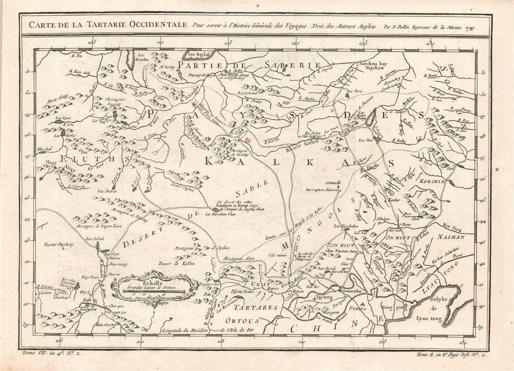
Carte de la Tartarie Occidentale, Pour servir à l'Histoire Générale des Voyages Tirée des Auteurs Anglois. Par N. Bellin Ingenieur de la Marine 1749.
1780 (dated) 8.75 x 12.25 in (22.225 x 31.115 cm) 1 : 8200000
1780 (dated) 8.75 x 12.25 in (22.225 x 31.115 cm) 1 : 8200000
Description
This is a 1749 Bellin map of the Gobi Desert and the eastern portion of the Silk Route region 'Tirée des Auteurs Anglois.' For 'Auteurs Anglois' read 'Thomas Kitchin', who produced the 1747 A Map of Western Tartary which the present map copies faithfully, and translates. Kitchin's map, itself, was drawn from Jesuit Missionary reports and the monumental 1734 Kirilov map of the Russian Empire.
The Map
The map extends from Lake Baikal in the north as far south as Beijing, east to the Gulf of Lyau-tong (Yellow Sea), and west as far as Chan-tong. The centrally-located Desert de Sable is the Gobi Desert. At its center is the supposed site of Karakorum, the semi-legendary ancient capital of the Mongol Empire. To the south beyond the desert are shown the Mongol territories north of the Great Wall of China (beyond which Peking can be found.) The map shows caravan routes, rivers (known and imagined) and settlements. Ruined cities are noted as is a remarkable sentinel post, far to the north of the wall, said to be marked with Chinese inscriptions. European cartographers had been in nearly complete ignorance of this region's true geography, and the speed (and thoroughness) with which this map was copied and propagated is a testament to European hunger for knowledge of this part of the world.Publication History and Census
This map appears on the market from time to time; Separate copies of the map and full copies of Prévost's Histoire and the Harpe editions of it are well represented in OCLC.CartographerS
Jacques-Nicolas Bellin (1703 - March 21, 1772) was one of the most important cartographers of the 18th century. With a career spanning some 50 years, Bellin is best understood as geographe de cabinet and transitional mapmaker spanning the gap between 18th and early-19th century cartographic styles. His long career as Hydrographer and Ingénieur Hydrographe at the French Dépôt des cartes et plans de la Marine resulted in hundreds of high quality nautical charts of practically everywhere in the world. A true child of the Enlightenment Era, Bellin's work focuses on function and accuracy tending in the process to be less decorative than the earlier 17th and 18th century cartographic work. Unlike many of his contemporaries, Bellin was always careful to cite his references and his scholarly corpus consists of over 1400 articles on geography prepared for Diderot's Encyclopedie. Bellin, despite his extraordinary success, may not have enjoyed his work, which is described as "long, unpleasant, and hard." In addition to numerous maps and charts published during his lifetime, many of Bellin's maps were updated (or not) and published posthumously. He was succeeded as Ingénieur Hydrographe by his student, also a prolific and influential cartographer, Rigobert Bonne. More by this mapmaker...
Thomas Kitchin (August 4, 1718 – June 23, 1784) was a London based engraver, cartographer, and publisher. He was born in London to a hat-dyer of the same name. At 14, Kitchin apprenticed under Emanuel Bowen, under whom he mastered the art of engraving. He married Bowen daughter, Sarah Bowen, and later inherited much of his preceptor's prosperous business. Their son, Thomas Bowen Kitchin, also an engraver joined the family business, which thereafter published in Thomas Kitchin and Son. From 1858 or so Kitchin was the engraver to the Duke of York, and from about 1773 acquired the title, 'Royal Hydrographer to King George III.' He is responsible for numerous maps published in the The Star, Gentleman's Magazine, and London Magazine, as well as partnering with, at various times, with Thomas Jefferys, Emmanuel Bowen, Thomas Hinton, Issac Tayor, Andrew Dury, John Rocque, Louis de la Rochette, and Alexander Hogg, among others. Kitchin passed his business on to his son, Thomas Bowen Kitchin, who continued to republish many of his maps well after his death. Kitchin's apprentices included George Rollos, Bryant Lodge, Thomas Bowen Kitchin, Samuel Turner Sparrow, John Page, and Francis Vivares. Learn More...
Ivan Kirillovich Kirilov (Иван Курилов, 1689 - April 14, 1737) was a Russian cartographer and surveyor active in Moscow in the late 17th and early 18th centuries. He is considered to be the Father of Russian Cartography. He was born to a mid-level government official serving under Peter the Great. When Peter founded the Russian Naval Academy in 1701 many educated families encouraged their male children to enroll. Kirilov was enrolled one year later in 1702, when he was just 13. There he studied navigation under the polymath Leontij Magnitzki, and his assistants. He graduated from the academy in 1707, taking up a position in the Navy Department, which allowed him to travel and study in other parts of Europe. He later transferred to the Civil Service Land Survey Department, where he became a clerk and surveyor. There he impressed his superiors and was recalled to Moscow in 1712, to work in the head office of the Estates Department (Pomyestni Prikaz). He was subsequently transferred to the Senate Chancellery where he rose through the ranks and his reputation as a master mapmaker grew. When Peter the Great instituted a empire-wide survey, Kirilov was put at his head. Kirilov compiled new and existing survey work into a series of map between 1726 and 1834, which eventually were published as the Russia's first scientific atlas, the Atlas Imperii Russici. After the initial publication of his atlas, Kirilov continued to compile additional maps of Russia into an even greater survey. Unfortunately, defeated by his excoriating work ethic, the dedicated cartographer contracted consumption and died four years later, in 1737. After his death, all of Kirilov's work was acquired by the St. Petersburg Academy and suppressed, so surviving examples are exceedingly rare. Learn More...
Antoine François Prévost d'Exiles (April 1, 1697 – November 25, 1763), usually known the Abbé Prévost, was a French author and novelist. Having had difficulty in his youth determining a preference for life in the military or life among the Jesuits, he eventually wound up with the Benedictines, with whom he took vows. Despite his taking the vows, the vows evidently did not take with him: in 1728 he abandoned his abbey and fled to London. Naturally, he became a writer. In this he was prolific, both producing his own work and translations of others. Beginning in 1726, he published the first volume of his Histoire générale des voyages, which he worked on for the remained of his life and which was completed by his associates after his death, stretching to 25 volumes. Learn More...
Source
De la Harpe, Abrégé de l'histoire générale des voyages. (Paris) 1780.
Condition
Very good condition. Few unobtrusive spots. Original folds visible, else a bold, sharp example.
References
OCLC 635289475.