
This item below is out of stock, but another example (left) is available. To view the available item, click "Details."
Details
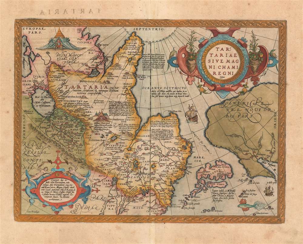
1570 / 1579 Ortelius Map of Tartary: China, Siberia, Japan
$1,800.00
1570 / 1601 Ortelius Map of Tartary
Tartary-ortelius-1570$1,000.00

Title
Tartariae Sive Magni Chami Regni typus.
1570 (undated) 14.5 x 19 in (36.83 x 48.26 cm) 1 : 20000000
1570 (undated) 14.5 x 19 in (36.83 x 48.26 cm) 1 : 20000000
Description
A richly-colored example of Ortelius' seminal map of Tartary, this is one of the first maps to focus on the North Pacific. While the map is primarily intended to detail Asia as dominated by the Great Khan, it is also notable for what it shows of America. The map includes what is now the west coast of the United States, northwestern Canada and Alaska, bit was then almost entirely unknown lands. It is the earliest obtainable map to name California. It also displays a strait separating Asia and America - the Strait of Asian - appearing long before the existence of such a strait was proved by discovery. The map is based on a partial conic projection, and depicts from the Black Sea to the Gulf of California, and from the Arctic to southern China, what Europeans then considered the extent of the Tartar Kingdom. In fact, much of the content north of China is mythical or loosely derived from the journals of Marco Polo, the legends of Prester John, and Biblical sources.
A Groundbreaking Map
This is one of the earliest maps to attempt the mapping of northeast Asia: prior maps relied entirely on the information of ancient geographers, whose concrete data seldom reached beyond what is now considered Eastern Europe. Ortelius' map is infused with considerable data from Marco Polo's 13th century voyages, but Ortelius also does much to reconcile the medieval knowledge of Asia with the 16th century revelations of the Western Hemisphere. The Pacific Ocean is optimistically narrow, particularly at the Strait of Asian separating the continents, encouraging the notion of a close connection between the Americas and the treasures of the orient.Treasure Cities in the Americas
Near America's peninsular California, six of the legendary Seven Cities of Gold are noted: Chicuich, Axa, Tiguas, Totonteas, Chicana, and Coana. The legend of the Seven Cities emerged in Europe long before Columbus, during the Moorish invasion of Spain. It was said that when the Moors invaded Porto in the early 8th century, the city’s seven bishops took all of their wealth and fled to sea. They landed on an island in the Atlantic called 'Antilla.' There, each of the seven bishops established a city. The island of Antilla actually appears on many early portolan charts of the Atlantic, but as navigators explored more and more of that ocean and failed to discover the Antilla, the Seven Cities were relocated to the unexplored American southwest.Richly Decorative and Evocative
The map is superbly engraved, with an elaborate strapwork-and-floral cartouche. The Pacific Ocean features a flying fish and a sailing ship plying the Strait separating Asia and America (something no European would do for centuries). In the upper right, the Grand Duke of Muscovy sits in a splendid tent; in Central Asia, another tent houses the Great Khan.A Text-Rich Map
The Asian portion of the map is heavily annotated, revealing much of Ortelius' sources:In Arctic Russia, beyond 70 degrees north:
The Nephalites are named Neptali after one of the 10 tribes with a Hebrew name, and after the Danites, who by way of punishment were called the Danes of the dark North, and they were on account of the claims of Rachel Balbah placed to the side, in the area of the Hudores or Iehudeores; in the year 476 they were victorious in their battle against Perosa. Others call them incorrectly Euthalites.In the ocean corresponding to the East Siberian Sea:
The Scythian ocean, according to Pliny, has sweet water, and he also says it contains many islands, as M. Paulus [Marco Polo] also says, but neither of the two tells about their number or location.Siberia:
Tabor or Tybur, center of the area of the Tartars, where once the Holy Books got lost, yet they are united under one king, who in 1540 first reached France and king Franciscus, and later, at the initiative of Charles the Fifth was burnt at the stake for his heresy, because he had secretly endeavoured to convert Christian kings to the Jewish religion, about which he had spoken with Charles the Fifth.At the furthest extreme of northeastern Asia:
ARSARETH: Here the ten tribes retreated, and changed from the Tatar or Tartar area to Scythia. Since then they are called Gauths or Gauthens, confirming Gods highest glory, and here lies the splendid kingdom of Cathai.Turkestan, in Central Asia:
Turkestan. The area from which the 10 tribes as allies living on this side of the mountain range have been called 900 years ago by the Persians to fight the armies of Ismael the Muslim.In the vicinity of Mongolia or Northern China:
Argon. Once there was in Asia a Christian kingdom, known to Prester John, and D. Thomas founded it [this city] in this place, so that it was in contact with the church of Rome, and was subjected to Rome through Prester John of Africa. Before it was defeated by the Goths, it was known as Crive Romove.In the Lower-Left Cartouche:
This map contains the area of Tartaria, with the remaining part of East Asia to the Morning Ocean, subject to the great Khan whose might is bounded by the river Ob, Lake Kataia, the Volga, the Caspian Sea, the river Chesel, the mountains of Usson, the area of Tibet, the river Caromora and the Ocean.Marco Polo's Japan:
The isle of Japan, called Zipangri by Marco Polo of Venice, formerly [called] Chrÿse, once attacked by the great Khan in war, but without success.
Publication History and Census
This map was first issued in 1570 to accompany Ortelius' great Atlas, Theatrum Orbis Terrarum, and was one of the first fifty-three maps included in the work. This map appears in four states, of which this is the third. (Over the course of the map's printing history, the hachuring on the coastlines was reworked several times: the long 7-9 mm hachure here correspond with van den Broecke's third state.) The typography of the Latin text on the verso identifies this specific example as belonging to a 1601 edition of the Atlas. Ortelius' masterpiece was successful, and is well represented in institutional collections.Cartographer
Abraham Ortelius (April 14, 1527 - June 28, 1598) also known as Ortels, was a cartographer, geographer, and cosmographer of Brabant, active in Antwerp. He was the creator of the first modern atlas, Theatrum Orbis Terrarum and is a seminal figure in the history of cartography. Along with Gerard Mercator and Gemma Frisius, he was a founder of the Netherlandish school of cartography. His connections with Spain - culminating in his 1575 appointment as Royal Cartographer to King Phillip II of Spain - gave him unmatched access to Spanish geographical knowledge during a crucial period of the Age of Discovery. Ortelius was born in 1527 in Antwerp. In 1547 he entered the Antwerp Guild of Saint Luke as an illuminator of maps. He began trading in books, prints, and maps, traveling regularly to the Frankfurt book and print fair, where in 1554 he met Mercator. He accompanied Mercator on journeys throughout France in 1560 and it was at this time, under Mercator's influence, that he appears to have chosen his career as a scientific geographer. His first published geographic work appeared in 1564, an eight-sheet cordiform world map. A handful of other maps preceded the 1570 publication of the first edition of the Theatrum Orbis Terrarum, which would prove to be his life work. Appearing with but 53 maps in its first edition, Ortelius' work expanded with new maps added regularly. By 1592, it had 134 maps. Many of Ortelius' maps remained the standard for nearly a century. He traveled extensively, but his genius was as a compiler, locating the best informed maps on which to base his own. His contacts throughout Europe and extending even (via the Portuguese) to the Far East were formidable. Moreover, many of his maps were based on his own scholarship, particularly his historical works. His theories of geography were particularly ahead of his time with respect to the notion of continental drift, the possibility of which he mused on as early as 1596, and which would be proven correct centuries later.
In a sense his greatest achievement was his successful navigation of the religious and political violence endemic to his city throughout his adult life: The Dutch Revolt, or Eighty Years' War (1568 - 1648), fully embroiled Antwerp. Although outwardly and officially recognized as Catholic (Arias Montanus vouched for Ortelius' Catholic orthodoxy prior to his appointment as Royal Geographer), Ortelius was able to separate himself from the religious furor which characterized the war in the low countries. Ortelius showed a glimpse of himself in a letter to a friend, regarding humanist Justus Lipsius: 'I do not know whether he is an adherent of the Pope or a Calvinist, but if he has ears to hear, he will neither be one nor the other, for sins are committed on both sides'. Ortelius' own explorations of Biblical history in his maps, and the Christogram contained in his own motto, suggest him to be a religious man, but his abjuration of political religious authorities mark him as an individualist. His tombstone at St Michael's Præmonstratensian Abbey in Antwerp bears the inscription, Quietis cultor sine lite, uxore, prole. ('served quietly, without accusation, wife, and offspring.') More by this mapmaker...
Source
Ortelius, A., Theatrum Orbis Terrarum, (Amsterdam) 1601.
Abraham Ortelius' magnum opus, Theatrum Orbis Terrarum, was the world's first regularly produced atlas, which 'set the standards for later atlases . . . It was the first undertaking of its kind to reduce the best available maps to an uniform format.' (Koeman) A modestly-sized work of fifty-three maps in its first edition of May 1570, it was an immediate success: there were three further editions that year, and the work remained in print for a total of 32 editions, the last of which was 1641, well after its author's 1598 death. Ortelius added to his atlas constantly, and by 1595 the Theatrum contained 147 maps. Ortelius is renowned generally as an editor, and indeed much of the Theatrum is compiled from a variety of sources: in such cases, Ortelius was scrupulous in naming his sources. But Ortelius was also a mapmaker in his own right: many of his maps are a distillation of various sources into his own work, and there were many maps - particularly in his atlas of Biblical and ancient history Parergon - which were entirely Ortelius' work. In his role as an editor, Ortelius followed in the footsteps of Munster, whose Cosmographia was, until Ortelius, the best window on the world for the curious European reader. In terms of the artistry of his maps, Ortelius oversaw the first great flourishing of copperplate engraving in the service of cartography to occur in Northern Europe. Ortelius' work provided the model for the atlases of Mercator, Hondius, Blaeu and all their progeny in the 17th century - many of whom were to produce faithful editions of Ortelius' maps in their own productions.
Condition
Very good. Overall age toning. Marginal mend well away from image.
References
Rumsey 10000.103(1570). van den Broecke Ortelius Atlas Maps, Ort 163.
Van der Krogt, P. C. J., Koeman's Atlantes Neerlandici, (3 Vols) 8050:31. Wheat, C. I., Mapping of the Transmississippi West, 1540 – 1861, #16. Wagner, H. R., The Cartography of the Northwest Coast of America To the Year 1800, #81. Cortazzi, H., Isles of Gold: Antique Maps of Japan, plate 16. Walter, L., Japan: A Cartographic Vision: European Printed Maps from the early 16th to the 19th Century, #11E.