
This item below is out of stock, but another example (left) is available. To view the available item, click "Details."
Details
1570 / 1579 Ortelius Map of Tartary: China, Siberia, Japan
1570 (undated) $1,800.00
1570 / 1609 Ortelius Map of Tartary (1st state)
Tartary-ortelius-1609$950.00

Title
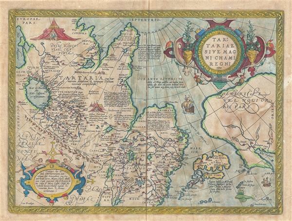
Tartariae Sive Magni Chami Regni typus.
1609 (undated) 14.5 x 19 in (36.83 x 48.26 cm) 1 : 20000000
1609 (undated) 14.5 x 19 in (36.83 x 48.26 cm) 1 : 20000000
Description
The first state of Ortelius' important 1570 map of Tartary. Among other things, this map is notable as the earliest obtainable map to name California. The map covers from the Black Sea to the Gulf of California and from the arctic to southern China. The map covers what was then considered by Europeans to be the extent of the Tarter Kingdom. In fact, much of the content north of China is mythical or loosely derived from the journals of Marco Polo, the legends of Prester John, and Biblical sources. There are copious annotations and, as we translate them below, much of this will become apparent to the reader.
This map is important. It is one of the earliest European mappings of northeast And, although fraught with speculation, reveals much. North American and Asia, are for example, quite close, separated only by the Narrow Strait of Anian. Although Alaska and the Bering Strait are at this time most assuredly unknown to Europeans, the speculation of a close connection between Europe and the western parts of America were common. Note how close Japan is to California – a clear layover of Columbian hopes that the New World may indeed lie close to the rich markets of Asia.
Also in America, six of the supposed Seven Cities of Gold are noted: Chicuich, Axa, Tiguas, Totonteas, Chicana, and Coana. The legend of the Seven Cities emerged in Europe long before Columbus, during the Moorish invasion of Spain. It was said that when the Moors invaded Porto in the early 8th century, the city’s seven bishops took all of their wealth and fled to sea. They landed on an island in the Atlantic called 'Antilla.' There, each of the seven bishops established a city. The island of Antilla actually appears on many early portolan charts of the Atlantic, but as navigators explored more and more of that ocean and failed to discover the Antilla, the Seven Cities were relocated to the unexplored American southwest.
The following translations from the Latin annotations will shed much light on the composition of this map:
The Nephalites are named Neptali after one of the 10 tribes with a Hebrew name, and after the Danites, who by way of punishment were called the Danes of the dark North, and they were on account of the claims of Rachel Balbah placed to the side, in the area of the Hudores or Iehudeores; in the year 476 they were victorious in their battle against Perosa. Others call them incorrectly Euthalites.This map was first issued in 1570 to accompany Ortelius' great Atlas, the Theatrum Orbis Terrarum. The atlas was issued in numerous editions well into the mid-1600s. This map appears in four states, of which this is the first. The variosu states can be most easily identified by the length of the hachuring. The earlies states had hachuring 2-3mm long, while some of the later states feature hachuring up to 9mm in length. In addition, portholes were added and removed from the ship throughout the states. Spanish text on verso.
The Scythian ocean, according to Plinius, has sweet water, and he also says it contains many islands, as M. Paulus [Marco Polo] also says, but neither of the two tells about their number or location.
Tabor or Tybur, center of the area of the Tartars, where once the Holy Books got lost, yet they are united under one king, who in 1540 first reached France and king Franciscus, and later, at the initiative of Charles the Fifth was burnt at the stake for his heresy, because he had secretly endeavoured to convert Christian kings to the Jewish religion, about which he had spoken with Charles the Fifth.
Here the ten tribes retreated, and changed from the Tatar or Tartar area to Scythia. Since then they are called Gauths or Gauthens, confirming Gods highest glory, and here lies the splendid kingdom of Cathai.
Turkestan. The area from which the 10 tribes as allies living on this side of the mountain range have been called 900 years ago by the Persians to fight the armies of Ismael the Muslim.
The great Khan (which in the language of the Tatars means emperor), the highest ruler of Asia.
Argon. Once there was in Asia a Christian kingdom, known to Prester John, and D. Thomas founded it [this city] in this place, so that it was in contact with the church of Rome, and was subjected to Rome through Prester John of Africa. Before it was defeated by the Goths, it was known as Crive Romove.
This map contains the area of Tartaria, with the remaining part of East Asia to the Morning Ocean, subject to the great Khan whose might is bounded by the river Ob, Lake Kataia, the Volga, the Caspian Sea, the river Chesel, the mountains of Usson, the area of Tibet, the river Caromora and the Ocean.
The isle of Japan, called Zipangri by Marco Polo of Venice, formerly [called] Chrÿse, once attacked by the great Khan in war, but without success.
Cartographer
Abraham Ortelius (April 14, 1527 - June 28, 1598) also known as Ortels, was a cartographer, geographer, and cosmographer of Brabant, active in Antwerp. He was the creator of the first modern atlas, Theatrum Orbis Terrarum and is a seminal figure in the history of cartography. Along with Gerard Mercator and Gemma Frisius, he was a founder of the Netherlandish school of cartography. His connections with Spain - culminating in his 1575 appointment as Royal Cartographer to King Phillip II of Spain - gave him unmatched access to Spanish geographical knowledge during a crucial period of the Age of Discovery. Ortelius was born in 1527 in Antwerp. In 1547 he entered the Antwerp Guild of Saint Luke as an illuminator of maps. He began trading in books, prints, and maps, traveling regularly to the Frankfurt book and print fair, where in 1554 he met Mercator. He accompanied Mercator on journeys throughout France in 1560 and it was at this time, under Mercator's influence, that he appears to have chosen his career as a scientific geographer. His first published geographic work appeared in 1564, an eight-sheet cordiform world map. A handful of other maps preceded the 1570 publication of the first edition of the Theatrum Orbis Terrarum, which would prove to be his life work. Appearing with but 53 maps in its first edition, Ortelius' work expanded with new maps added regularly. By 1592, it had 134 maps. Many of Ortelius' maps remained the standard for nearly a century. He traveled extensively, but his genius was as a compiler, locating the best informed maps on which to base his own. His contacts throughout Europe and extending even (via the Portuguese) to the Far East were formidable. Moreover, many of his maps were based on his own scholarship, particularly his historical works. His theories of geography were particularly ahead of his time with respect to the notion of continental drift, the possibility of which he mused on as early as 1596, and which would be proven correct centuries later.
In a sense his greatest achievement was his successful navigation of the religious and political violence endemic to his city throughout his adult life: The Dutch Revolt, or Eighty Years' War (1568 - 1648), fully embroiled Antwerp. Although outwardly and officially recognized as Catholic (Arias Montanus vouched for Ortelius' Catholic orthodoxy prior to his appointment as Royal Geographer), Ortelius was able to separate himself from the religious furor which characterized the war in the low countries. Ortelius showed a glimpse of himself in a letter to a friend, regarding humanist Justus Lipsius: 'I do not know whether he is an adherent of the Pope or a Calvinist, but if he has ears to hear, he will neither be one nor the other, for sins are committed on both sides'. Ortelius' own explorations of Biblical history in his maps, and the Christogram contained in his own motto, suggest him to be a religious man, but his abjuration of political religious authorities mark him as an individualist. His tombstone at St Michael's Præmonstratensian Abbey in Antwerp bears the inscription, Quietis cultor sine lite, uxore, prole. ('served quietly, without accusation, wife, and offspring.') More by this mapmaker...
Source
Ortelius, A., Theatrum Orbis Terrarum, (Amsterdam) 1609.
Condition
Good. Overall age toning. Old framers tape on back (verso) margins - does not impact printed area. Old color. Spanish text on verso.
References
Ort 163 (Koeman/Meurer: 47, Karrow: 1/67, vdKrogtAN: 8050:31). Wheat, C. I., Mapping of the Transmississippi West, 1540 – 1861, #16. Wagner, H. R., The Cartography of the Northwest Coast of America To the Year 1800, #81. Cortazzi, H., Isles of Gold: Antique Maps of Japan, plate 16. Walter, L., Japan: A Cartographic Vision: European Printed Maps from the early 16th to the 19th Century, #11E.