
This item below is out of stock, but another example (left) is available. To view the available item, click "Details."
Details
1961 Sahab City Plan or Map of Tehran, Iran
1961 (dated) $800.00
1958 Sahab Pictorial Map of Tehran, Iran
TehranIran-sahab-1958$675.00

Title
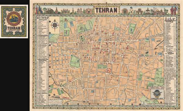
Tehran.
1958 (dated) 19 x 27 in (48.26 x 68.58 cm) 1 : 17000
1958 (dated) 19 x 27 in (48.26 x 68.58 cm) 1 : 17000
Description
This is a rare pictorial map of Tehran issued in 1958 by Abbas Sahab, considered the 'Father of Iranian Cartography.' Based upon Addass's own pen and ink drawing, this map covers central Tehran centered on Parke E Shahr. It extends west roughly as far as Jeyhoon Street, east as far as the Doulab and Armenian Cemeteries, north to Meydan-e Jahad and south to include the Tehran Railway Station. Pictorial elements include illustrations on the map proper as well as drawings across the top of the map depicting historical figures and monuments.
BThis map was published only a few years after the 1953 coup that made Mohammad Reza Shan of Iran. Reza launched a series of progressive reforms, the White Revolution, including the controversial move of given women the right to vote. Note the illustration here of a woman wearing the cap and gown graduating from Tehran University. This was also a period of greater international influence in Iran and the current map bears manuscript annotations associated with the former owner, an American diplomat visiting Tehran. We have been told that this may have been Herbert M. Bratter, an economist who worked with the United State government in the Far East, but have no verification of the claim. In any case, various site of interest are noted, including Offices of Commerce, Finance, and Industry. The map also identifies a bar near Tehran University – an marker of another era and an unlikely sight in modern Tehran, where the Shia-dominated Muslim government has forbidden alcoholic beverages.
This is the first state of the second edition of Sahab's map of Tehran. The first edition was published in 1956 and features regional insets. A second edition, as here, was issued early in 1958. The present state dates to February of that year. A second state of the second edition was issued in October of 1958 and is recognizable for being printed in blue ink with Fârsi text under the lower border.
B
This is the first state of the second edition of Sahab's map of Tehran. The first edition was published in 1956 and features regional insets. A second edition, as here, was issued early in 1958. The present state dates to February of that year. A second state of the second edition was issued in October of 1958 and is recognizable for being printed in blue ink with Fârsi text under the lower border.
Cartographer
Abbas Sahab (1921 – April 2, 2000) was an Iranian cartographer and publisher active in Terhan in middle part of the 20th century. He is considered the 'Father of Iranian Cartography.' Sahab was born in Fam, Tafresh district, Iran. He was the son of Ostad Abolghasem Sahab Tafreshi, an Iranian writer, publisher and, from 1935, founder of the Sahab Drafting and Geographic Institute.This was the first private geographical publisher in modern Iran. The company was soon passed to Abbas, under whose guidance the company published over 1500 works, including maps, atlases, prints, and scientific and medical illustrations. Abbas himself traveled throughout Iran, often mapping individual towns and adding his own artistic flair to the maps. His most important maps illustrate Tehran, Esfahan, and Mazandaran. He also traveled extensively abroad, producing maps of Afghanistan, Pakistan, Iraq, and Turkey. After his death, the Sahab Drafting and Geographic Institute was taken over by his sons and remains an active concern to this day. More by this mapmaker...
Condition
Very good. Minor archival reinforcements on verso. Attached to original binder.
References
OCLC 705134715.