This item has been sold, but you can get on the Waitlist to be notified if another example becomes available, or purchase a digital scan.
1936 Friedlander Map of Tel Aviv and Jaffa
TelAviv-friedlander-1936$975.00


Title
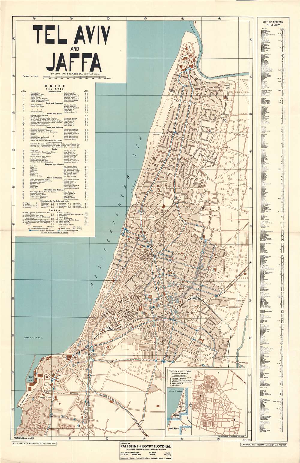
Tel Aviv and Jaffa.
1936 (dated) 39.5 x 25.5 in (100.33 x 64.77 cm) 1 : 7500
1936 (dated) 39.5 x 25.5 in (100.33 x 64.77 cm) 1 : 7500
Description
This is an impressive large-scale 1936 map of Tel Aviv and Jaffa, Israel, by Zvi H. Friedlander, issued during the Fifth Aliyah (1929 - 1939). The map reflects Tel Aviv at the height of its Pre-War growth, when thousands of Jews, fleeing ever increasing antisemitism in Europe, made a new home in British Palestine. It also reflects the height of Bauhaus construction in Tel Aviv.
Tel Aviv
Tel Aviv was founded in 1909 by Jewish immigrants making Aliyah. Jaffa was the largest port in Ottoman Palestine, and the destination of most Jewish immigrant ships. Many immigrants moved on to Jerusalem or Haifa, but some remained near Jaffa, founding a new city, Tel Aviv, just to the north. In short order, Tel Aviv became the fastest growing city in Israel. The well-educated immigrants with avant-garde European tastes, built Tel Aviv in the Bauhaus aesthetic - today it maintains the largest concentration of Bauhaus architecture in the world. In 1925, the Scottish civil engineer Patrick Geddes (1854 - 1932), was commissioned to develop a masterplan for Tel Aviv in the 'Garden City' model of Ebenezer Howard. He planned wide avenues, well placed public spaces, civil buildings, and more, transforming the future Tel Aviv into one of the most commodious and first modern planned cities in what would soon become Israel. At the southern part of this map, the convoluted streets of the old Jaffa port, still a primarily Arab area, stand out in sharp contrast to the orderly lines farther north.Publication History and Census
This is the first English-language edition of Friedlander's map of Tel Aviv. It was simultaneously issued in Hebrew. Its production was sponsored by the Jerusalem, Palestine and Egypt Lloyd travel agency. The present English edition was printed by Freytag and Berndt of Vienna - where sophisticated printing machines and higher quality paper were more readily available. It is the only edition printed in Austria, as by the time the second edition was issued in 1939, the Anschluss made Vienna unwelcome to Jewish business. This map is rare. We note just 4 examples in institutional collections: the National Library of Israel, National Archives U.K., Staatsbibliothek zu Berlin, and the University of California Los Angeles. No current market history.Cartographer
Zvi H. Friedlander (1898 - 1987; צבי פרידלנדר) was a prominent Israeli cartographer active throughout the 20th century. Based in Haifa, he was a prolific mapmaker, active until about 1972. His work captured the transition from British Palestine to the Israeli State and many modern Israeli cities undergoing their most rapid expansion and urbanization. More by this mapmaker...
Condition
Very good. Minor wear and some verso reinforcement on old fold lines - especially at fold intersections.
References
National Library of Israel: Tel Aviv 16. National Archives U.K., CO 1047/753. Staatsbibliothek zu Berlin: 8'' Kart. X 1883/58. University of California Los Angeles, G7504.T4 1936.F7.