This item has been sold, but you can get on the Waitlist to be notified if another example becomes available, or purchase a digital scan.
1870 Johnson Map of the World showing Temperature and Ocean Currents
TempCurrents-johnson-1870$50.00

Title
Johnson's Ocean Currents and the Great River Basins of the World, by Prof A. Guyot. / Johnson's World showing the Distribution of the Temperature of the Air; by Prof A. Guyot.
1870 (dated) 23.25 x 16.5 in (59.055 x 41.91 cm)
1870 (dated) 23.25 x 16.5 in (59.055 x 41.91 cm)
Description
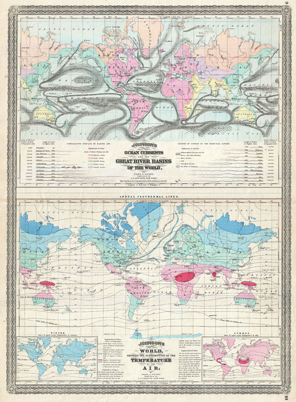
This is A. J. Johnson 1870 thematic map of the world illustrating Currents, River Basins, and Air Temperature. Combines two maps, both based upon the work of Geologist A. Guyot, on a single folio sheet. The upper map depicts the world's ocean currents and illustrates the Great River Basins of the world. Under the map a comparative chart indicates the lengths of the world's great rivers. The lower map depicts the average air temperatures for different parts of the world. Two smaller maps at the bottom of the main map show variances for winter and summer. Features the spirograph style border common to Johnson's atlas work in 1870. Steel plate engraving prepared by A. J. Johnson for publication as page nos. 9 - 10 in the rare 1870 edition of his New Illustrated Atlas… Dated and copyrighted, 'Entered according to Act of Congress in the Year of 1870, by A. J. Johnson in the Clerks Office of the District Court of the United States for the Southern District of New York.'
CartographerS
Alvin Jewett Johnson (September 23, 1827 - April 22, 1884) was a prolific American map publisher active from 1856 to the mid-1880s. Johnson was born into a poor family in Wallingford, Vermont, where he received only a basic public education. He is known to have worked as a school teacher for several years before moving to Richmond, Virginia. Johnson got his first taste of the map business as a salesman and book canvasser for J. H. Colton. The earliest Johnson maps were published with D. Griffing Johnson (no clear relation) and date to the mid-1850s; however, it was not until 1860 that the Johnson firm published its first significant work, the Johnson's New Illustrated (Steel Plate) Family Atlas. The publication of the Family Atlas followed a somewhat mysterious 1859 deal with the well-established but financially strapped J. H. Colton cartographic publishing firm. Although map historian Water Ristow speculates that Colton sold his copyrights to Johnson and his business partner, another Vermonter named Ross C. Browning (1822 - 1899), a more likely theory is that Johnson and Browning financially supported the Colton firm in exchange for the right to use Colton's existing copyrighted map plates. Regardless of which scenario actually occurred, it is indisputable that the first Johnson atlas maps were essentially reissues of earlier Colton maps. Early on, Johnson described his firm as the 'Successors to J. H. Colton and Company'. Johnson's business strategy involved transferring the original Colton steel plate engravings to cheaper lithographic stones, allowing his firm to produce more maps at a lower price point. In 1861, following the outbreak of the American Civil War (1861 - 1865) Johnson and Browning split their firm between two offices. Johnson moved from Richmond, Virginia, to New York City. Browning remained in Richmond, where he published at least one more edition of the atlas in 1862, at the height of the war. Johnson and Browning published two editions of the Johnson Atlas: 1860 (Richmond and New York) and 1861 (Richmond and New York). Sometime in 1861, Browning's portion of the firm (or perhaps the New York portion?) was purchased by Benjamin P. Ward, whose name subsequently replaced Browning's on the imprint. The 1863 issue of the Family Atlas was one of the most unusual, it being a compilation of older 'Johnson and Browning' maps, updated 1862 'Johnson and Ward' maps, and newer 1863 maps with a revised border design. The 1864 issue of the Family Atlas is the first fully 'Johnson and Ward' atlas. Johnson published one more edition of the atlas in partnership with Ward in 1865, after which Johnson bought out Ward. The next issue of the atlas, 1866, is the first purely 'Johnson' atlas with all new map plates, updated imprints, and copyrights. The Family Atlas went through roughly 27 years of publication, from 1860 to 1887, outliving Johnson himself, who died in 1884. Johnson maps from the Family Atlas are notable for their unique borders, of which there are four different designs, the 'strapwork border' from 1860 to 1863, the 'fretwork border' from 1863 to 1869, the 'spirograph border' in 1870 to 1882, and a more elaborate version of the same from 1880 to 1887. In addition to the Family Atlas, Johnson issued numerous wall maps, pocket maps, and in the 1880s, the Cyclopedia. Johnson maps are known for their size, accuracy, detail, and stunning, vivid hand coloring. Johnson's maps, purely American in their style and execution, chronicle some of the most important periods in American history, including the Civil War, the Westward Expansion, and the Indian Wars. Today Johnson's maps, especially those of the American West, are highly sought after by map collectors and historians. More by this mapmaker...
Arnold Henry Guyot (September 28, 1807 - February 8, 1884) was a Swiss-American geologist and geographer. Though he intended to join the ministry, during his education he became familiar with the natural sciences, working with close friend Louis Agassiz and forming a connection with von Humboldt. At Agassiz’ urging he studied glaciers in the Swiss Alps, and presented to the Geological Society of France what would be the first important data on glacial motion. He became professor of history and geography at the College of Neuchâtel. On its closing, he emigrated to the United States with his mother, sister and nephew, the draftsman Ernest Sandoz. There he would become a lecturer, first at the Lowell Institute, and later as a professor of geography and geology at Princeton. During his professorship he worked for the Smithsonian Institution in order to develop a national meteorological system, which would result in the formation of the United States Weather Bureau. He was accompanied in his emigration by his produced a number of text books, as well as a series of educational wall maps. Guyot produced maps in conjunction with his nephew from about 1857 to 1881. His work with Sandoz included the first detailed maps of the Catskills and the Southern Appalachians. Learn More...
Source
Johnson, A. J., Johnson's New Illustrated Family Atlas of the World, (New York: Johnson and Ward) 1870.
Johnson's New Illustrated Family Atlas was produced in numerous editions from about 1860 to 1887. Johnson's first atlas was mostly likely the 1859 edition of Colton's General Atlas which both aesthetically and comprehensively very similar to the 1860 first edition of the New Illustrated Family Atlas. Johnson's atlas was noteworthy in its day as one of the few commercially produced American atlases that could compete with more established European Atlases. Although he called the atlas 'Steel Plate' on the title page for marketing purposes, Johnson in fact incorporated modern lithographic printing techniques and lower quality woven wood pulp paper to economically produce large format maps in quantity. He also began publishing the New Illustrated Family Atlas on the cusp of the American Civil War, a decision that proved fortuitous, as the war corresponded to a general increased interested in cartography. For the most part, Johnson's Atlas was sold by subscription; nonetheless it became so popular that for at time he was considered the largest publisher in the world. Other than the first edition, the atlas itself has no true editions. Rather, Johnson incorporated updated maps as they became available, so each example of the Johnson atlas might well contain unexpected and scarce individual maps. Johnson's map of the American Southwest, for example, appeared in more than 17 different states, each illustrating minor variations to the rapidly chasing geography of that region. Moreover, Johnson's offered a service whereby he would mail updated map pages that could be tipped into older atlases to keep them current. Generally speaking, Johnson's atlas was issued in four periods - each defined by a distinctive decorative border. The earliest edition featured a strapwork border that appears as rolled and decoratively cut leather. This border work remained in use until 1863. In 1864 Johnson started using an updated fretwork or grillwork border that resembles worked iron - as in a decorative fence. This border was in use from 1863 to 1869. The 1863 edition of Johnson's atlas used both borders and is considered transitional. From 1870 to 1882, Johnson introduced a new border that featured elaborate Spirograph style geometric designs, which was used from 1870 to 1882. After 1880 a new border different but aesthetically similar to the Spirograph border began appearing. Certain editions of the atlas issued from 1880 - 1882 were transitional.
Condition
Very good condition. Original centerfold. Blank on verso.