This item has been sold, but you can get on the Waitlist to be notified if another example becomes available, or purchase a digital scan.
1796 Carey Map of Tennessee
TennasseeGovernment-carey-1796$600.00

Title
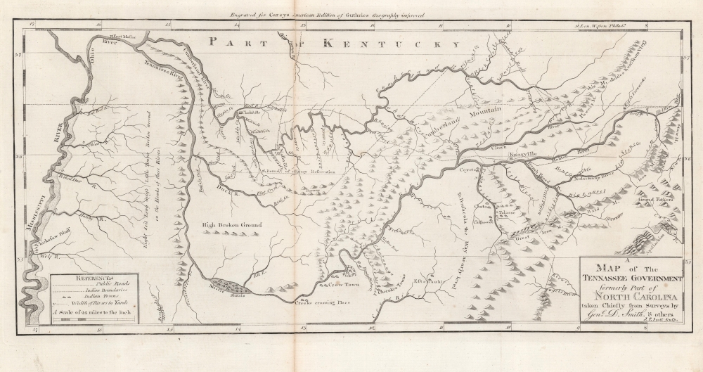
A Map of The Tennassee Government formerly Part of North Carolina taken Chiefly from Surveys by Genl. D. Smith and others.
1796 (undated) 10.25 x 20.75 in (26.035 x 52.705 cm) 1 : 1393920
1796 (undated) 10.25 x 20.75 in (26.035 x 52.705 cm) 1 : 1393920
Description
This is a c. 1796 Mathew Carey map of the 'Tennessee Government', considered one of the earliest specific maps of Tennessee.
A Closer Look
Coverage embraces from the modern-day Kentucky-Illinois border (where the Cumberland River and Tennessee River meet the Ohio River) south to Muscle Shoals in Alabama. The cartography was 'taken chiefly' from the surveys of General Daniel Smith. Frontier towns, forts, settlements, and Native American villages are identified, including Knoxville, Nashville, Clarksville, and Fort Massac. The Cumberland and Tennessee Rivers, with tributaries, are illustrated in detail. The Cumberland and Appalachian Mountains are labeled, with annotations admitting to lack of knowledge about the terrain. A key, labeled 'References', appears in the lower left.The Evolution of Tennessee
The entirety of Tennessee was originally included in North Carolina's coast-to-coast charter which, for practical political purposes, was generally assumed to terminate at the Mississippi River. Tennessee's easternmost counties were thus originally the westernmost counties of North Carolina. In the years following the American Revolutionary War (1775 - 1783), the government of North Carolina was too depleted to defend its westernmost settlements against American Indian attacks or support their right to navigate the Mississippi. Tennesseans realized they would have to look to themselves for military support. In 1784, Tennessee's eastern counties rallied and attempted to form the new state of 'Franklin' with John Sevier as governor. Meanwhile, in western Tennessee, the Cumberland Settlements ratified the Cumberland Compact and even brokered a treaty with Spain. Despite bold aims, both the Cumberland Compact and attempts to promote Franklin lacked federal support and were suppressed by North Carolina. This changed in 1789, when North Carolina ratified the constitution and joined the Union. In doing so it gave up the rights to its western land paving the way for Tennessee's statehood in 1795-96.Publication History and Census
This map was engraved by Joseph T. Scott for publication in Mathew Carey's Carey's General Atlas in 1796. This piece is well represented in institutional collections but is scarce on the private market.CartographerS
Matthew Carey (January 28, 1760 - September 16, 1839) was a Dublin born publisher who established himself in Philadelphia in the late 18th and early 19th century. A young man of socially progressive views, Carey's first known publication, produced when he was but 17 years old, was a pamphlet criticizing dueling. Another pamphlet, issued in the same year, attacked the Irish penal code. Shortly afterwards, in 1779, legal issues, possibly arising from his liberal political activism, forced Carey to flee to Paris. In Paris, Carey had the good fortune to befriend the visiting American diplomat and founding father, Benjamin Franklin (1706 - 1790). As an Irishman chafing under the rule of England, Carey sympathized with and admired the American revolutionary. The liberally minded pair struck up a lifelong friendship and Carey was hired to work at Franklin's press in Passy, France. A year later, Carey returned to Ireland and resumed his politically provocative publishing career with The Freemans's Journal and The Volunteer's Journal. It didn't take long for political pressure to once again force Carey from Ireland - this time to America (1784). Although largely without funds, Carey convinced Gilbert du Motier, Marquis de Lafayette (1757 - 1834), who he knew from Franklin's Paris circle, to lend him funds to establish a new publishing concern in Philadelphia. Despite this loan, Carey's firm remained under financed and opened on a shoestring budget. It was most likely his limited budget that led Carey to some of his most important publishing innovations. At the time cartographic publishing was dominated by large printing houses in London and Paris where most, if not all, of the work was completed in house. Without the finances to emulate this large publishing houses, Carey was forced to outsource much of his publishing work. This set the stage for subsequent American publishers who, in order to compete effectively with European firms, relied on an often bewildering network of alliances and collaborations. Carey was also a master of republishing many of his own maps in multiple different atlases and formats to maximize their profitability. His most important work is without a doubt the 1795 issue of the American Atlas the first atlas to be published in America. Carey died in 1839 but was succeeded by his son Henry Charles Carey (1793 - 1879) who, in partnership with his brother-in-law Isaac Lea (1792 - 1886), published numerous important maps and atlases under the Carey and Lea, Lea Brothers, and Lea and Blanchard imprints. More by this mapmaker...
Joseph T. Scott (fl. c. 1794 - 1811) was a Philadelphia-based publisher and engraver. Scott engraved many of the maps for Mathew Carey's Carey's American edition of Guthrie's Geography improved published in 1795. He also engraved maps that appeared in John Gibson's Atlas Minimus published in 1798. Learn More...
Source
Carey, M., Carey's General Atlas, (Philadelphia: Carey) 1796.
Condition
Good. Repaired centerfold split.
References
Wheat, J. C. and C. F. Brun, Maps and Charts Published in America Before 1800: A Bibliography. Second Revised Edition, (New Haven: Yale University) 1985, #650. Rumsey 2542.018. OCLC 53086413.