1749 Vaugondy Map of Guyana, Suriname, French Guiana, and Brazil
TerreFermeEast-vaugondy-1749$150.00
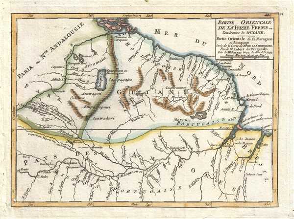

Title
Partie Orientale de la Terre Ferme ou l'on trouve la Guiane. Partie Orientale du Fl. Maragnon ou Amazone tirée de la carte de Mr. de la Condamine. Par le Sr. Robert de Vaugondy, Fils de Mr. Robert Geog. du Roi.
1749 (dated) 6.5 x 9 in (16.51 x 22.86 cm) 1 : 11000000
1749 (dated) 6.5 x 9 in (16.51 x 22.86 cm) 1 : 11000000
Description
This is a hand colored 1749 Didier Robert de Vaugondy map of Guyana, Suriname, French Guiana, and Brazil. The map stretches from Venezuela to Brazil and from the Caribbean Sea to the Amazon. The Province of Tierra Firme (Terre Ferme) were the mainland coastal possessions of Spain's New World Empire surrounding the Caribbean Sea. The mythical Cassipa Lake is depicted near the center. Cassipa Lake can trace its origins back to the myth of El Dorado and Sir Walter Raleigh. It was said that when Lake Cassipa receded, large deposits of gold would be revealed. Lake Cassipa and another mythical lake, Lake Parima, appeared on many early maps of South America. Through miscommunications with the locals, explorers came to believe that rivers and tributaries were in fact large, fantastic lakes. Four rivers are depicted flowing from Lake Cassipa, all of which run into the Orinoco (Orinoque) River.
Another intriguing, but much less mythical, inclusion on this map is the Marañón, or Amazon, River. The river stretches across the entire lower portion of the map, dotted by towns and tributaries as it winds its way toward its mouth where it drains into the Atlantic Ocean. The map declares that part of Brazil to the 'Amazon country' (Pays des Amazones) and only labels the coastal section of that territory as Brazil.
Guiana is divided between the Dutch section and the French section, with the Dutch capital at Surinam and the French at Cayenne. Guiana is traversed by numerous rivers, but towns are only located along the coast.
This map was published by Gilles Robert de Vaugondy in his Atlas Universel, Portatif et Militaire in the 1749 edition.
Cartographer
Robert de Vaugondy (fl. c. 1716 - 1786) was French may publishing from run by brothers Gilles (1688 - 1766) and Didier (c. 1723 - 1786) Robert de Vaugondy. They were map publishers, engravers, and cartographers active in Paris during the mid-18th century. The father and son team were the inheritors to the important Nicolas Sanson (1600 - 1667) cartographic firm whose stock supplied much of their initial material. Graduating from Sanson's maps, Gilles, and more particularly Didier, began to produce their own substantial corpus. The Vaugondys were well-respected for the detail and accuracy of their maps, for which they capitalized on the resources of 18th-century Paris to compile the most accurate and fantasy-free maps possible. The Vaugondys compiled each map based on their own geographic knowledge, scholarly research, journals of contemporary explorers and missionaries, and direct astronomical observation. Moreover, unlike many cartographers of this period, they took pains to reference their sources. Nevertheless, even in 18th-century Paris, geographical knowledge was limited - especially regarding those unexplored portions of the world, including the poles, the Pacific Northwest of America, and the interiors of Africa, Australia, and South America. In these areas, the Vaugondys, like their rivals De L'Isle and Buache, must be considered speculative or positivist geographers. Speculative geography was a genre of mapmaking that evolved in Europe, particularly Paris, in the middle to late 18th century. Cartographers in this genre would fill in unknown lands with theories based on their knowledge of cartography, personal geographical theories, and often dubious primary source material gathered by explorers. This approach, which attempted to use the known to validate the unknown, naturally engendered rivalries. Vaugondy's feuds with other cartographers, most specifically Phillipe Buache, resulted in numerous conflicting papers presented before the Academie des Sciences, of which both were members. The era of speculative cartography effectively ended with the late 18th-century explorations of Captain Cook, Jean Francois de Galaup de La Perouse, and George Vancouver. After Didier died, his maps were acquired by Jean-Baptiste Fortin, who in 1787 sold them to Charles-François Delamarche (1740 - 1817). While Delamarche prospered from the Vaugondy maps, he defrauded Vaugondy's window Marie Louise Rosalie Dangy of her rightful inheritance and may even have killed her. More by this mapmaker...
Source
Robert de Vaugondy, G., Atlas Portatif, Universel, et Militaire, (Paris: Vaugondy, Durand, Pissot) 1749.
Condition
Very good. Blank on verso. Original press mark visible.
References
Pedley, M. S., Bel et Utile, p. 217, 489. OCLC 159770338.