This item has been sold, but you can get on the Waitlist to be notified if another example becomes available, or purchase a digital scan.
1865 Van de Velde Wall Map of the Holyland / Israel / Palestine
TerreSainte-vandevelde-1865$500.00

Title
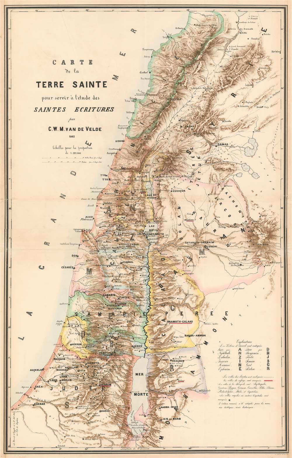
Carte de la Terre Sainte pour servir à l'etude des Saintes Ecritures par C.W.M. van de Velde.
1865 (dated) 51.5 x 32.75 in (130.81 x 83.185 cm) 1 : 325000
1865 (dated) 51.5 x 32.75 in (130.81 x 83.185 cm) 1 : 325000
Description
One of the most important 19th-century maps of the region, this is the 1865 Charles William Meredith van de Velde map of the Holy Land. Created from Van de Velde's surveys, the map depicts from Syria to the Dead Sea and from the Mediterranean Sea to Mount Zalmon (Mt. Tsalmon). Per Mapping the Holy Land: The Foundation of a Scientific Cartography of Palestine, Van de Velde's map of Palestine
represented the complete body of Western geographical knowledge on Palestine, critically compiled, the verified on-site and completed by his own measurements and his own (physical) experience, including the hardships needed to make a scientific map.Van de Velde effortlessly blends the modern and the ancient. Myriad cities and towns are labeled throughout, including Jerusalem, Hebron, Tyre, Sidon, and Damascus, while different colors shade the regions historically belonging to each of the Twelve Tribes.
Publication History and Census
This map was created by Charles William Meredith van de Velde and published in 1865. English and French editions were published, but the publication history of each is difficult to trace. It appears that at least two different states of the English edition were published, one in 1858 and the other in 1865. We have only found evidence of one French edition. Four examples of the 1865 French edition are cataloged in OCLC. They are part of the collections at the Bibliothèque de la Ville de la Chaux-de-Fonds, the Bibliothèque publique et universitaire - Neuchâtel, the Bibliothèque de Genève, and the Bibliothèque cantonale et universitaire - Lausanne.Cartographer
Charles William Meredith van de Velde (December 3, 1818 - March 20, 1898) was a Dutch cartographer, painter, missionary, lieutenant commander second class, and honorary member of the Red Cross. Born in Leeuwarden, Van de Velde was educated at the Naval Academy at Medemblik and earned the rank of lieutenant commander second class. He worked in the topographical office in Batavia (modern-day Jakarta) from 1830 until 1841 and was eventually appointed the office's director. He published the 1857 Faces of the Dutch East Indies about his time in Batavia. The work was illustrated by fifty plates of his own composition. He was forced to return to Europe in 1844 due to health concerns, but visited Ceylon (Sri Lanka), the Transvaal, and the Cape of Good Hope during the voyage. Once back in Europe, Van de Velde devoted himself to geographic, ethnographic, and cartographic pursuits, and also worked as a missionary, draftsman, and nurse. He visited Palestine in 1851 and undertook measurements and made drawings that he used to publish two maps in 1857 through Justus Perthes. He published a work on Palestine and Syria in 1857 in Paris (written in French) that contained 100 of his illustrations. Van de Velde worked with the Dutch Red Cross from its inception in 1863 and was present at the opening conference in Geneva that year. The following year he was sent to Denmark to help treat soldiers wounded during the Prussian-Austrian War, and six years later was called to France to work with the Dutch doctors treating soldiers wounded during the Franco-Prussian War. Van de Velde died in Menton, France on March 20, 1898. More by this mapmaker...
Condition
Very good. Two panels joined. Some wear along old fold lines. Minor verso repairs and reinforcements at old fold intersections.
References
OCLC 1039070477.