1882 Ernest W. DuBois Schoolboy manuscript map of Texas
Texas-ernestwdubois-1882$550.00

Title
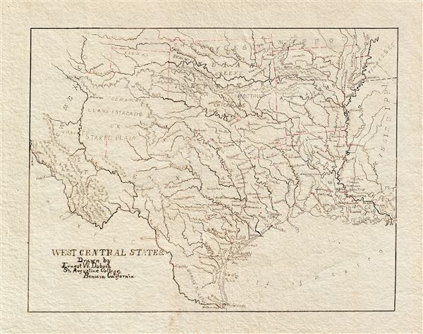
West Central States. Drawn by Ernest W. Dubois, St. Augustine College, Benicia, California.
1882 (undated) 9 x 11 in (22.86 x 27.94 cm) 1 : 6000000
1882 (undated) 9 x 11 in (22.86 x 27.94 cm) 1 : 6000000
Description
An attractive manuscript schoolboy / schoolgirl map of Texas by Ernest W. DuBois. Entitled the 'West Central States,' this map in fact focuses primarily on Texas with the adjacent Indian Territory (Oklahoma), Louisiana, and Arkansas also included. The map is finely drawn throughout with great attention to rivers and town placement. No counties are identified.
The goals of these exercises were more far-reaching than teaching geography. Studemts learned penmanship, each map often using three or more lettering styles. Mapmaking sharpened the retention and recall of factual information. Students were encouraged to take pains in their draftsmanship, and often achieved beautiful flourishes of artistic expression in their maps. But most peculiar to the American iterations of educational mapping was the goal of instilling a sense of civic pride and responsibility. Indeed, the key desired result of education in the post-Revolutionary-War United States was to prepare for the education of the next generation of American citizens.
Schoolgirl / Schoolboy Maps
While the use of mapmaking in teaching is first seen in Europe, mainly England, the Schoolgirl / Schoolboy Map became a peculiarly American pedagogical tool in the first part of the 19th Century, a period in which standards and purposes of education were changing. While boys were frequently taught the practical execution of surveys and charts, the production of attractive and informative maps appears to have been primarily the domain of young women. Such maps can be found of the World, the United States, or more specific maps of states. These were usually based on generally available reference maps, such as those found in the atlases produced by Carey and Lea, Finley, and Mitchell.The goals of these exercises were more far-reaching than teaching geography. Studemts learned penmanship, each map often using three or more lettering styles. Mapmaking sharpened the retention and recall of factual information. Students were encouraged to take pains in their draftsmanship, and often achieved beautiful flourishes of artistic expression in their maps. But most peculiar to the American iterations of educational mapping was the goal of instilling a sense of civic pride and responsibility. Indeed, the key desired result of education in the post-Revolutionary-War United States was to prepare for the education of the next generation of American citizens.
Publication History and Census
The author, Ernest W. DuBois, no doubt drew this map during his schoolboy years as St. Augustine College for Boys, an Episcopalian school in Benicia, California. DuBois was born in 1870, suggesting that this map must have been drawn between 1880 and 1887, when DuBois attended the school between the ages of 10 and 17. DuBois parents emigrated to Marin County, California in 1863. He spent his life in California where he amassed considerable real-estate holdings.Cartographer
Mount and Page (fl. 1701 - 1760) was a London based firm of religious and maritime publishers that flourished in the 18th century. With the publication of the 1732 English Pilot, the Mount and Page name became well-known worldwide as an imprint of nautical charts. The firm was founded at Tower Hill, London, in 1701 by Richard Mount (1654 - 1722) and his apprentice Thomas Page (1780 - March 15, 1733). Mount had previously been in partnership with his father-in-law William Fisher (1631 - 1691) and inherited the business on the latter's death. Page completed his apprenticeship in 1716. Now fully partnered, Mount and Page subsequently acquired the map plates several defunct British nautical chart publishers, including Greenville Collins, Jeremiah Seller, Charles Price, and John and Samuel Thornton - thus nearly monopolizing the British nautical chart business. The firm consequently received several lucrative government contracts and thereby flourished throughout the 18th century, making the fortunes of both families. Successive generations of Mounts and Pages worked in the business, and the families intermarried. Its staple titles were The English Pilot and Navigatio Britannica by John Barrow. By the 1760s, Richard Mount's grandson John Mount (1725 - 1786) was able to retire to Berkshire where he built the stately mansion, Wasing Place. John's son William (1753 - 1815) was the last to work in the map business, and later generations went into politics. More by this mapmaker...
Condition
Very good. Manuscript. Heavy stock.