
1881 Matthews Northrup Promotional Railway Map of Texas

Map of the South West.
Railways, Land, and Immigration in the Lone Star State.
- Digital Map Information
- Suitable for large format printing
- Full resolution TIFF file
- ICC color profile embedded
- Delivered instantly via download link
Railways, Land, and Immigration in the Lone Star State.
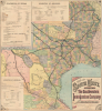
This is a striking 1881 Matthews, Northrup and Company promotional railroad map of Texas and the Southwest, published by the Southwestern Immigration Company (SIC) and bearing the stamp of the Gulf, Colorado and Santa Fe Railway's (GCSF) Land Department. The SIC promoted immigration to Texas as a way for railroad companies to sell off their significant landholdings and create new customers for commercial and passenger traffic.A Closer Look
Texas dominates the composition, with coverage extending northeast through Arkansas and Missouri to St. Louis and south through Mexico to Mexico City and Veracruz. Counties and states are differentiated by color shading, while rivers, mountain ranges, settlements, military posts, and water sources provide a detailed geographical framework. This broad scope corresponds to the regional ambitions of the Southwestern Immigration Company (that is, the railroads); Texas appears within a transportation system linking the Mississippi Valley, Gulf ports, and the Mexican interior. The railroads command attention through exceptionally broad black lines punctuated by light station circles that overwhelm finer geographical details. Prominently named systems include members of the Southwestern Immigration Company, such as the Missouri Pacific Railroad, the International Great Northern Railroad, and the Gulf, Colorado and Santa Fe (discussed below).The map includes both extant and projected lines, many of the latter being long delayed or never being built as frenetic railroad construction began to slow in 1882, and slowed more dramatically after the Panic of 1884. A prominent example is the Gulf, Colorado and Santa Fe, projected to cut across a difficult stretch of terrain in northwestern Texas to Santa Fe here, but in reality never extending beyond Sweetwater, instead ultimately reaching Santa Fe via connections as part of a larger Atchison, Topeka and Santa Fe Railway network.
Large panels supply statistics for Texas, Arkansas, and Louisiana. Their subjects reach beyond crops and livestock to taxation, education, shipping, and railroad mileage. The Texas panel reports 3,301 miles of railroad completed by January 1, 1881, with another 2,000 miles under contract. It also advertises various types of public land for sale and extols the state's educational institutions and charitable endowments.
The Southwestern Immigration Company
The Southwestern Immigration Company was established in Austin in 1880 by a consortium of regional railroads to fill the promotional void created after the Texas Constitution of 1876 prohibited state expenditures for immigration recruitment (note that this prohibition did not stop this map from appearing in a state publication). Representing seven major rail lines operating across Texas, Arkansas, and Louisiana (including the Gulf, Colorado and Santa Fe Railway), the private enterprise sought to populate rural frontiers, liquidate railroad land grants, and stimulate freight and passenger traffic throughout the region. Under the leadership of its president, former Texas State Grange master William W. Lang (1828 - 1900), the company aggressively marketed the state's agricultural potential through promotional pamphlets, resource handbooks, and widely circulated publications such as the present map. Lang spent much of the period between 1881 and 1884 in Europe soliciting prospective settlers, collaborating with transatlantic carriers like the North German Lloyd steamship line to coordinate charter vessels that brought thousands of German, Czech, and Austrian immigrants through the port of Galveston onto connecting interior rails. Although the syndicate disbanded in the mid-1880s as individual railroads built out their own proprietary colonization bureaus and federal restrictions like the Alien Contract Labor Act of 1885 reshaped transatlantic recruitment, the company played an influential role in catalyzing the demographic and agricultural development of post-Reconstruction Texas.The Gulf, Colorado and Santa Fe Railway
An oval stamp in the Gulf of Mexico identifies the Land Department of the GSSF at Galveston, Texas. Galveston business leaders chartered this railway on May 28, 1873, to create a direct trade route to the Texas interior that bypassed yellow fever quarantines and commercial bottlenecks in rival Houston. Construction began in 1875 from Galveston and pushed through central Texas, creating rail towns like Temple and Rosenberg while opening vast agricultural markets to deepwater shipping. In the following years, the GC and SF quickly developed into a vital transportation artery across the American Southwest. But amid the railroad-building frenzy of the 1870s and 1880s, the company faced competitive pressure and the need to connect to a national network. As a result, the GCSF reached an agreement in 1886 with the Atchison, Topeka and Santa Fe Railway (ATSF) to extend its line north across Indian Territory; the tracks met in Purcell, Oklahoma, in April 1887, providing a continuous corridor from Kansas City to the Gulf of Mexico. Although the ATSF controlled it, the GCSF operated as a legally distinct subsidiary for decades to comply with Texas statutes requiring in-state headquarters and corporate charters. It served as a critical conduit for grain, cotton, oil, and passenger traffic until 1965, when regulatory changes allowed ATSF to formally absorb its corporate structure into the parent system, whose lines remain active today under BNSF Railway.Publication History and Census
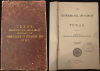
This map was prepared by Matthews, Northrup and Company for the Southwestern Immigration Company in 1881. It is accompanied by an 1882 report written by A. W. Spaight for the state's Department of Insurance, Statistics, and History titled The Resources, Soil, and Climate of Texas: Report of Commissioner of Insurance, Statistics, and History. The map is independently cataloged at Texas Tech University, the Kansas Historical Society, the University of Houston, the Texas State Library and Archives, Duke University, and the New York Public Library. The entire book is more widespread in institutional collections, but both the map and book are scarce to the market.Cartographer
Matthews-Northrup Works (fl. c. 1895 - 1930) were a Buffalo, New York based, in their own words, "writing, designing, engraving, printing, [and] binding" firm. The firm was founded by James Newson Matthews (November 21, 1828 - December 20, 1888) as the J. N. Matthews Company. William Phelps Northrup (April 2, 1850 - February 2, 1929) later joined the company as an apprentice and then partner, at which point the firm was reincorporated as the Matthews-Northrup Works. The Matthews-Northrup Works rose to prominence as publishers and printers of railroad maps, with dozens to their credit. When James died, his shares were inhered by George Edward Matthews (1855 - 1910), who ran the business until his death in 1910. Also in 1910, they famously redesigned the cover of National Geographic Magazine. Despite some six previous cover changes in just 21 years, the Matthews-Northrup layout proved so popular that it was used for nearly 50 years. The firm can also take credit for the Winchell typeface, designed in 1903 under E. E. Winchell's tenure as art director. Curiously, the partners of Matthews-Northrup maintained an unusual affectation in which only the officers of the company could wear beards or mustaches. In this same spirit, the firm also had its own private social club, the Fellowcraft Club, where the all-male employees could relax, play pool, drink and dine. Matthews-Northrup maintained offices on Washington Street, Buffalo, where they were based, as well as Madison Square, New York City, Garden Tower, Boston, and the Citizens Building in Cleveland. Further Details...
Source
Spaight, A., The Resources, Soil, and Climate of Texas: Report of commissioner of insurance, statistics, and history, (Galveston: A. H. Belo and Co.) 1882.
Condition
Very good. Thin paper reinforced at old fold intersections on verso. Lower left margin extended.
References
OCLC 17476697. Konecny, Lawrence H. and Clinton Machann, 'German and Czech Immigration to Texas: The Bremen to Galveston Route, 1880 - 1886', Nebraska History, vol. 74 (1993), p. 138.