
1931 Mining and Industrial Wall Map of Portuguese East Africa (Mozambique)

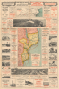
Map of Portuguese East Africa Published and presented by the Lourenço Marques Port and Railways Administration.
British Commerical Interests in Portuguese East Africa.
- Digital Map Information
- Suitable for large format printing
- Full resolution TIFF file
- ICC color profile embedded
- Delivered instantly via download link
British Commerical Interests in Portuguese East Africa.
This large (60 x 39.75 in) 1931 advertising wall map of Portuguese East Africa was issued by the Lourenço Marques Port and Railways Administration to promote Mozambique's capital as a maritime gateway to southern Africa's industrial interior. The British firm Mining and Industrial Publications of Africa published the map, and its copious advertisements for British firms underscore Portugal's limited ability to realize its ambitions for Lourenço Marques (now Maputo) and the dependence of the region on British commercial services.A Closer Look
This large sheet contains a central map (measuring 16.5 x 25.75 in.) surrounded by advertisements, photographs, and an inset map displaying connections between the Transvaal and Portuguese East Africa. The principal map embraces Mozambique from the Rovuma River frontier south to Lourenço Marques, with adjoining portions of Tanganyika, Nyasaland, Northern and Southern Rhodesia, the Transvaal, Swaziland, and Natal. Green shading highlights concessions around Beira granted by the Mozambique Company, a royal chartered company akin to the Dutch East India Company (though in this case dependent on British capital). Conspicuous red labels identify agricultural products and mineral resources, including gold, silver, copper, iron, coal, cotton, sugar, tobacco, sisal, copra, groundnuts, cattle, and ivory. Thus, the map is primarily meant to locate commodities in relation to the roads, railways, rivers, and ports through which they could reach buyers.The transportation key distinguishes operating and proposed railways, light railways, main and secondary roads, and tracks. Offshore, red routes differentiate passenger-and-cargo services from cargo-only lines, with distances between ports supplied along the routes. Submarine cables, lighthouses, and wireless stations complete a picture of commercial connectivity that extends beyond freight movement. The map's coastal network links Lourenço Marques with Inhambane, Beira, Chinde, Quelimane, Mozambique Island, and Porto Amélia, while its inland lines connect the colony with neighboring markets.
The inset 'diagram' above the main map makes the publication's central purpose even clearer. Under the heading identifying Lourenço Marques as the key port for the Transvaal, railways connect Johannesburg and Pretoria with the coast through Komatipoort and Ressano Garcia. Red shipping routes radiate from Lourenço Marques toward Europe, Asia, Australia, and New Zealand. The diagram places the port at the junction of an inland railway system and international sea lanes. At the same time, the heading promises economical freight handling and comfortable passenger connections.
Photographs and Commercial Advertising
Above and below the main map, two broad panoramas display the central station, warehouses, wharf, goods yards, and coaling installations of Lourenço Marques. Smaller photographs illustrate locomotives, a railway turntable, dry docks, cranes, and cold-storage facilities. Some three dozen advertisements in English, French, Portuguese, German, Dutch, and Italian function as a commercial directory for Portuguese East Africa. Standard Bank, Barclays, and Banco Nacional Ultramarino appear alongside shipping lines, forwarding agents, insurers, warehouse operators, and merchants. English and French text predominates, with the former in black and the latter in red.Portuguese East Africa amid British Commercial Dominance
Between the late 19th century and the early 1930s, the commercial architecture of Portuguese East Africa was structurally dependent on, and integrated with, neighboring British colonies and concessions. With the Witwatersrand gold rush and the British South Africa Company's expansion into Southern Rhodesia and Nyasaland, Mozambique's coastal geography made it the natural maritime gateway for the landlocked interior. British capital heavily underwrote the territory's transit infrastructure: the Delagoa Bay Railway linked the port of Lourenço Marques directly to the Pretoria-Johannesburg industrial belt, while the Beira Railway connected the port of Beira to Salisbury (Harare) and the Shire Highlands. Furthermore, swathes of central and northern Mozambique were outsourced to chartered concessionary entities (especially the Mozambique Company and, until 1929, the Niassa Company) which relied overwhelmingly on British finance, shipping lines, and merchant houses rather than Portuguese metropolitan capital.This commercial nexus was cemented by formalized migrant labor agreements that tied Portuguese colonial revenue directly to British-dominated mining operations. Through treaties such as the 1901 Modus Vivendi, the 1909 Transvaal-Mozambique Convention, and the 1928 Mozambique Convention, the Witwatersrand Native Labour Association (WENELA) secured legal recruitment rights for tens of thousands of Mozambican workers south of the Save River. In return, South African authorities guaranteed that a fixed minimum quota of rail-borne import traffic to the Transvaal was routed through Lourenço Marques, while a portion of miners' wages was paid to the Portuguese administration in gold bullion. This reciprocal arrangement provided the Portuguese colonial state with its most lucrative stream of customs dues and foreign exchange until the Great Depression and the rise of António de Oliveira Salazar's Estado Novo in the early 1930s, which initiated protectionist policies aimed at curbing foreign concessionary control.
Publication History
This sheet was printed in 1931 by Mining and Industrial Publications of Africa Ltd. for the Lourenço Marques Port and Railways Administration. It was most likely intended to hang in the offices of companies that shipped through Lourenço Marques and often, as discussed above, had a very close relationship with Portuguese colonial authorities. We know of only two other examples of this map, held by the Bibliothèque nationale de France and the Universiteit Antwerpen.Cartographer
Mining and Industrial Publications of Africa, Ltd. (fl. c. 1927 - 1950) was a British publisher of maps and commercial reference works based in London, with offices in Johannesburg. Its publications concerned the geography, natural resources, transport, agriculture, and industries of eastern and southern Africa. It was best known for reference publications ('manuals') relating to various African colonies and concessions in eastern and southern Africa. The firm also occasionally published large-format, colorful maps, including of Kenya (1927) and Portuguese East Africa (1931). In 1929, the company moved into Africa House in London. The firm appears to have suffered from the effects of the Great Depression and its output dropped off significantly after 1933, but it did put out publications periodically until 1950. Further Details...
Condition
Very good. Laid down on poster linen.
References
OCLC 762485819. Great Britain, Foreign Office, Convention between His Majesty's Government in the Union of South Africa and the Government of the Portuguese Republic regarding Native Labour from Mozambique, Railway Matters and Commercial Intercourse, Treaty Series No. 9 (1930), Articles 32 - 33. MacDonald, Andrew, 'Forging the frontiers: Travellers and documents on the South Africa-Mozambique border, 1890s - 1940s', Kronos, vol. 40, no. 1 (2014), pp. 154 - 177.