This item has been sold, but you can get on the Waitlist to be notified if another example becomes available, or purchase a digital scan.
1780 Bonne Map of Texas, Louisiana, and New Mexico
Texas4-bonne-1780$187.50

Title
Le Nouveau Méxique, avec la Partie Septentrionale de l'Ancien, ou de la Nouvelle Espagne.
1780 (undated) 9 x 13.25 in (22.86 x 33.655 cm) 1 : 10750000
1780 (undated) 9 x 13.25 in (22.86 x 33.655 cm) 1 : 10750000
Description
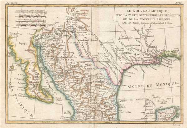
This is a beautiful c. 1780 Bonne map of northern Mexico and Texas. The map depicts the region from the Pacific Ocean through Mexico, Texas, and Louisiana to western Florida, and extends north as far as the Mission of St. Jeronimo de Taos (just north of Santa Fe) and south as far as Guadalajara and the northern Yucatan. Highly detailed, place names, Indian villages, missions, and riverways are labeled throughout. In the Texas region, a city of 'Texas' is identified, presumably the old Mission de Los Tejas from which name 'Texas' is derived. Just to the east of this city there is a notation regarding the 1665 death of the explorer La Salle. In present-day Arizona, the Gila River is referenced as the 'Rio de los Apostolos.' This map is heavily based on the work of D'Anville and was issued as plate 28 in the 1780 edition of Bonne's important Atlas de Toutes les Parties Connues du Globe Terrestre.
Cartographer
Rigobert Bonne (October 6, 1727 - September 2, 1794) was one of the most important French cartographers of the late 18th century. Bonne was born in Ardennes à Raucourt, France. He taught himself mathematics and by eighteen was a working engineer. During the War of the Austrian Succession (1740 - 1748) he served as a military engineer at Berg-op-Zoom. It the subsequent years Bonne became one of the most respected masters of mathematics, physics, and geography in Paris. In 1773, Bonne succeeded Jacques-Nicolas Bellin as Royal Cartographer to France in the office of the Hydrographer at the Depôt de la Marine. Working in his official capacity, Bonne compiled some of the most detailed and accurate maps of the period - most on an equal-area projection known erroneously as the 'Bonne Projection.' Bonne's work represents an important step in the evolution of the cartographic ideology away from the decorative work of the 17th and early 18th century towards a more scientific and practical aesthetic. While mostly focusing on coastal regions, the work of Bonne is highly regarded for its detail, historical importance, and overall aesthetic appeal. Bonne died of edema in 1794, but his son Charles-Marie Rigobert Bonne continued to publish his work well after his death. More by this mapmaker...
Condition
Very good. Even overall toning. Light wear along original centerfold. Blank on verso.
References
Burrus, E.J. pl.17; Lowery, W. 545; Phillips, P.L. (Atlases) 652-28; Wheat, C.I. (TM) 187. OCLC 30102884.