This item has been sold, but you can get on the Waitlist to be notified if another example becomes available, or purchase a digital scan.
1844 Emory Map of the Republic of Texas
TexasRepublic-emory-1844-2$4,750.00


Title
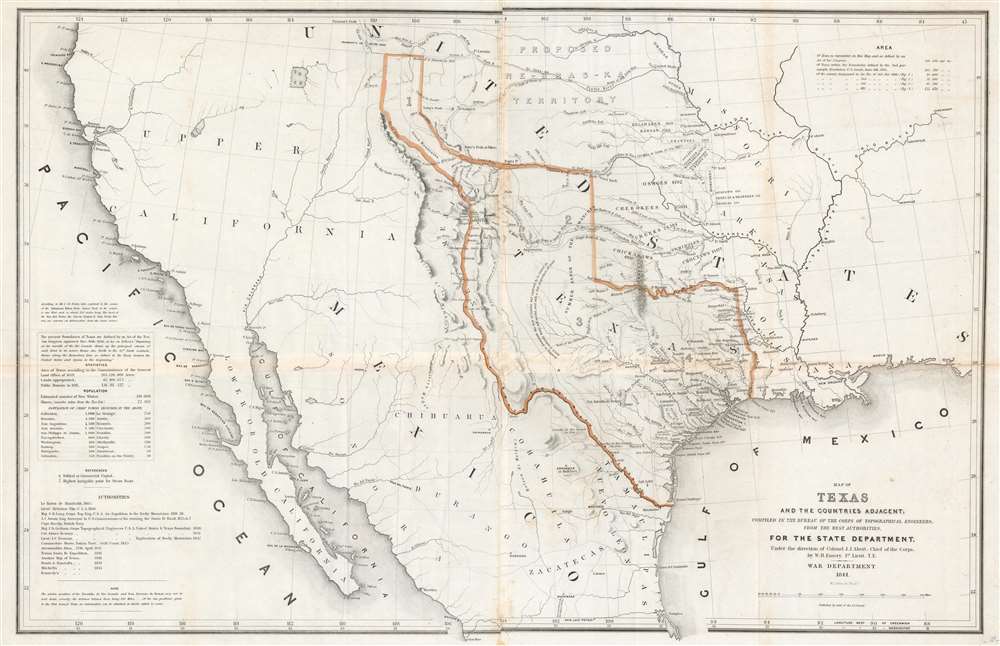
Map of Texas and the Countries Adjacent: Compiled in the Bureau of the Corps of Topographical Engineers; From The Best Authorities, for the State Department, Under the Direction of Colonel J. J. Albert, Chief of the Corps; by W. H. Emory, 1St. Lieut. T.E.
1844 (dated) 21.75 x 33.25 in (55.245 x 84.455 cm) 1 : 4562000
1844 (dated) 21.75 x 33.25 in (55.245 x 84.455 cm) 1 : 4562000
Description
A seminal production, this 1844 large-format edition map of the Republic of Texas by the U.S. Topographical Engineer, W. H. Emory, is the most important pre-war map of Texas. Centered on the vast claims of the Republic of Texas, Emory's map offers expansive coverage extending from the Pacific to west Florida and from South Pass (modern day Wyoming) to Tampico, Mexico. This map is significant on a number of levels. First, it is the first scientifically surveyed map of the Texas region. Second, it serves as the official U.S. acknowledgement of the full territorial claims of the Republic of Texas. Third, it is a vital reconnaissance of the Texas region in anticipation of the breakout of the Mexican-American War (1846 - 1848). Fourth, it establishes the Texas claims that would be fought over during the Mexican-American War. Fifth and finally, it lays down the Texas borders that would later be copied by Disturnell in his 'Treaty Map' of 1847, formalizing the U.S-Mexican border.
Republic of Texas
The Republic of Texas was a short-lived nation established in March of 1836 when it ceded from Mexico. Following the independence of Mexico from Spain, the American Stephen Fuller Austin led a group of 300 empresarios to settle Texas, near Austin, where they received a grant from the Mexican government. As more Americans moved to Texas, resentment and strife began to build between the American settlers and Mexican authorities. This and other factors ultimately led to the Texan Revolution in 1835 and the declaration of Texan independence in 1836. Texas remained an independent republic until it joined the United States 10 years later in 1846.Texas at its Fullest Expression
This map exhibits the Texas border configuration at its fullest expression, expanding northwards with the 'Stovepipe' reaching into modern day Wyoming, and west to include Santa Fe. H. Bailey Carroll in the Southwestern Historical Quarterly (Vol. 50, No. 2) comments on this map:This map is important even from the antiquarian viewpoint. It was made by men having excellent technical standards for 1844. It reveals in a striking manner the extent of geographical information about Texas and the Southwest....
The map is further important with reference to two boundary disputes having to do with Texas:The map shows clearly that the original assumption on the part of the government of the United States was that Texas was to be annexed with boundaries as defined by the Texan Congress on December 19, 1836. Twelve years before the Treaty of Guadalupe Hidalgo, Texas claimed the area between the Nueces and the Rio Grande. The Old Alcalde, Chief Justice O. M. Roberts, made the classic statement of the case in State vs. Bustamente (47 Tex. 320):
- (1) the Nueces-Rio Grande
- (2) the western boundary of Texas
Texas claimed the territory [between the Nueces and the Rio Grande], in defining its boundaries on the 19th day of December, 1836. In 1846, the claim was perfected by possession, and by actual exercise of exclusive jurisdiction, and from that time it was lost by the State of Tamaulipas, in Mexico, for all purposes whatever, whether of judicial action or the exercise of powers relating to eminent domain. And it never afterwards recovered such lost powers.The disputed western boundary of Texas was substantially, but not entirely, fixed in the Compromise of 1850. This Abert-Emory map is important in showing the Texan claim before the 1850 settlement and in demonstrating that the Texan claim had been accepted as valid by the United States.
The Peter's Colony
The map notes several settlements of interest, some of which shed light on migration patterns. One of these, the 'Kentucky Settlement' appears on the Red River west of the Cross Timbers. This settlement is more properly known as Peter's Colony. The colony consisted of four empresario land grants by the Republic of Texas to a consortium of American and English investors headed by William Smalling Peters. The consortium was headquartered in Louisville, Kentucky, hence the name on the map. The original boundary of Peters Colony started on the Red River at the mouth of Big Mineral Creek, currently in western Grayson County, running south 60 miles, then west 22 miles, then back north to the Red River, and then east along the Red River to the point of origin at Big Mineral Creek. According to the contract the empresarios were required to recruit 200 families from outside the Republic in three years. The ownership of the colony ultimately fell apart due to infighting and lack of immigration, followed by legal problems in the 1850s.Large and Small Format Editions
There are two editions of this map, the present large format edition and a roughly half-sized edition prepared for the Senate report. According to Streeter, (1543A)The order of priority of the two issues of the large-scale map (entry Nos. 1543, 1543A) and of the two editions, one large scale (entry No. 1543) and the other in smaller scale (entry No. 1543B), cannot now be determined, but it is probable that the large-scale map was issued before the edition on smaller scale. A resolution passed June 11, 1844, by the Senate called for the publication of 1000 copies of the map 'provided it can be done for the sum of $400,' and on December 19, 1844, the Senate voted that 5000 more copies be furnished 'provided the cost...does not exceed 12 cents per copy, including paper, printing, pasting and coloring.
Fort Ross
Beyond the boundaries of Texas, the map offers significantly less detail, but still much of interest. Near the panhandle the 'Proposed Ne-Bras-ka Territory' is noted. To the west of the stovepipe there are two large unnamed lakes - clearly preliminary illustrations of Great Salt Lake and Utah Lake. Far to the west, just north of San Francisco Bay a 'Russian Establishment', likely Fort Ross, is noted. Fort Ross was the southernmost outpost of the Russian-American Compnay. The map also notes lands granted to various American Indian nations west of the Missouri River, including the Kickapoo, Delaware, Kansas, Shawnee, Ottoes, Cherokee, Seneca, and Quapaws, among others. The routes of Pike and Fremont are noted, although when this map was issued, the full extent of Fremont's explorations had not yet been published.Publication History and Census
This map was published by the order of the U.S. Senate. The engraving is generally attributed to William James Stone. There are two editions, the present large format edition and a roughly half-sized edition prepared for the Senate report. Although published contemporaneously, this larger format is often considered to be the first. We note several examples in the OCLC, but it is difficult to assess if they represent the large-format edition, as here, or the more common smaller format.CartographerS
William Hemsley Emory (September 7, 1811 - December 1, 1887) was an American surveyor, civil engineer, and Army officer. Born in Queen Anne's County, Maryland, Emory graduated from the United States Military Academy at West Point in 1831, was assigned to the Fourth Artillery, and resigned from service in 1836 to pursue civil engineering. He returned to the army in 1838 to serve in the newly-formed Army Corps of Topographical Engineers. During the Mexican-American War, Emory served in the Army of the West under the command command of Stephen Watts Kearny. While serving with Kearny, he kept a detailed journal that was then published as Notes of a Military Reconnaissance from Fort Leavenworth to San Diego and soon became an important guidebook for the route to Southern California. After the war, Emory served as part of the team that surveyed the United States-Mexican border. When the American Civil War started, Emory was stationed in Indian Territory and immediately realized the likelihood that Confederates would capture him and his men. To avoid this, Emory quickly secured the services of Black Beaver, the famous Lenape warrior, to guide them out of the territory. Emory and his troops, on their way from Fort Washita to Fort Leavenworth, captured a number of their Confederate pursuers, which were the first prisoners taken during the war. Emory then served in the Army of the Potomac, in the Western Theater, and in the Shenandoah Valley Campaign of 1854. After the war, Emory held the post of commander of the Department of the Gulf during Reconstruction and, in September 1874, President Ulysses S. Grant ordered Emory to New Orleans, where he successfully negotiated a peace with the white supremacist paramilitary organization the White League, which led to the White League being disbanded. Emory married Matilda Wilkins Bache on May 29, 1838 in Philadelphia, with whom he had two sons, both of which served in the United States armed forces. Matilda Bache was Alexander D. Bache's sister. Alexander Bache was one of the most influential superintendents of the United States Coast Survey. More by this mapmaker...
Army Corps of Topographical Engineers (fl.1838 - 1863) refers to the an elite branch of the U.S. Army created on July 4, 1838 to perform civil mapping and survey work throughout the United States. The origins of the Corps of Topographical Engineers can be traced back to the American Revolutionary War, where General George Washington recognized the need for accurate surveys pursuant to military action. Shortly following the war, in 1779, a civilian engineering corps was created by act of Congress. Identified in 1802 by Thomas Jefferson, the "Corps of Engineers," which was based at West Point, the group participated in the War of 1812 and in later in the fortification of New Orleans. It was not until 1838, however, that a separate group of "Topographical Engineers" was formally recognized. This elite group, consisting only of officers, most of whom were trained in surveying and engineering by the esteemed Andrew Ellicott at West Point, never numbered more than 36 individuals - the best and brightest. This small but determined group played a central role in the mapping and exploration of the American West. Few branches of the military can boast such a distinguished alumni. Their names resonate throughout the map of the west and include John Charles Fremont, Zebulon Pike, George Meade, Kemble Warren, William Amiel Weeks, A. B. Gray, Randolph B. Marcy, James H. Simpson, Howard Stansbury, John W. Gunnison, William Ludlow, and Robert S. Williamson. The onset of the American Civil War brought an abrupt end to the surveying activity of the Topographical Engineers. Many of the most prominent engineers went on to distinguished military careers on both sides of the War Between the States. The Army Corps of Topographical Engineers itself was folded into the Corps of Engineers on March 31, 1863. Though the Army Corps of Engineers continues to do military and civil survey work to this day, the elite club of adventures that formed the Topographical Engineers were no more. Learn More...
William James Stone (c. 1800 - 1865) was an English-born American engraver, lithographer, and sculptor based in Washington D.C. Stone emigrated to the United States in 1804 where he studied engraving under Peter Maverick (1780 - 1831) in New York. Stone started his firm in Washington D.C. in 1815 where he capitalized on the printing of government maps and documents. His most significant accomplishment is his 1823 facsimile of the Declaration of Independence – probably the most exact and iconic version of that document ever printed. Stone is said to have worked three years on his copy of the Declaration of Independence. Among his cartographic works are Emory's map of Texas and Graham's 1836 map of Provincetown. Stone retired from printing to pursue sculpture in the 1840s. He died in 1865. Learn More...
Condition
Good. Areas of infill along central horizontal fold line. Reinforced along central horizontal fold line. Light foxing. Light toning along original fold lines.
References
Rumsey 0262.001. Martin, James C., and Martin, Robert S., Map of Texas and the Southwest, 1513 - 1900, #33. ; Wheat, C. I., Mapping of the Transmississippi West, 1540 – 1861, #478.