This item has been sold, but you can get on the Waitlist to be notified if another example becomes available, or purchase a digital scan.
1940 Colortext Map of the Theater of War (WWII)
TheatreofWar-colortext-1940$275.00

Title
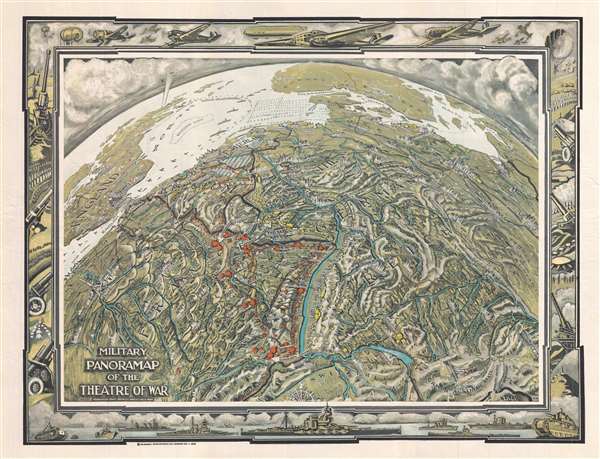
The Military Panoramap of the Theatre of War. Observation Point 200 Miles Directly Above Bern.
1940 (dated) 16 x 21 in (40.64 x 53.34 cm)
1940 (dated) 16 x 21 in (40.64 x 53.34 cm)
Description
This is a highly unusual 1940 military map of Europe illustrating the Theater of War in the first years of World War II. Produced in the spirit of Richard Edes Harrison using a globular perspective with exaggerated topography, this map presents Europe from a point far above Bern, Switzerland. The map covers from Ireland to Latvia and from Scandinavia to Switzerland. Central to the map is the Rhine River. To either side of the Rhine, the French Maginot Line (in red), and German Siegfried Line (in yellow), both layovers from World War I, present the illusion of impenetrable defenses. Military activity is every, but especially in the seas, where warplanes navigate towards London and rows of mines defend the North Sea and the entrances to the Baltic. The map is surrounded by a large decorative border featuring machines of war, ranging from battleships, to tanks, to warplanes.
This map was published by Chicago based Colortext Publications in 1940, making it the second to last production of that company. There is no artist identified, although the monogram 'C:H' appears in the lower right. There are at two known variants of this map, one in color, as here, and another in black and white (see Rumsey 11277.00). Today this map is rare. The OCLC identifies only a single example, in the University of California, Los Angeles.
This map was published by Chicago based Colortext Publications in 1940, making it the second to last production of that company. There is no artist identified, although the monogram 'C:H' appears in the lower right. There are at two known variants of this map, one in color, as here, and another in black and white (see Rumsey 11277.00). Today this map is rare. The OCLC identifies only a single example, in the University of California, Los Angeles.
Cartographer
Colortext Publications (c. 1933 – 1950) was a Chicago based firm active in the middle part of the 20th century. The firm's earliest work is a series of pamphlets associated with the Chicago Century of Progress International Exposition (1933 - 1934). Following the exposition Colortext partnered with various artist to create a series of pictorial maps known as 'Story Maps.' The firm partnered with such notable pictorial map artists as Ernest Dudley Chase, Egbert G. Jacobson, Julio de Diego, A. Walker, and W.E. Vogelear. Although it is unclear who founded the firm, it is registered business at 8 South Michigan Avenue, Chicago, as early as 1933. In 1938 and 1940, the firm produced to exceptional publications, a panoramic view of Chicago and the Military Panoramap of the Theatre of War. These depart markedly from the 'Story Map' model and reveal a greater level of sophistication than evident in Colortext's earlier publications. Sometime after World War II Colortext was acquired by the Chicago businessman and druggist Paul J. Mandalbach. The firm's last publication was in 1950, a Story Map of the West Indies. More by this mapmaker...
Condition
Very good. Blank on verso.
References
Rumsey 11277.000. OCLC 990214319.