This item has been sold, but you can get on the Waitlist to be notified if another example becomes available, or purchase a digital scan.
1670 Van Der Aa Map or View of Tientsin or Tianjin, China
Tiencienwey-vanderaa-1670$175.00

Title
Tiencienwey.
1670 (undated) 8 x 12.75 in (20.32 x 32.385 cm)
1670 (undated) 8 x 12.75 in (20.32 x 32.385 cm)
Description
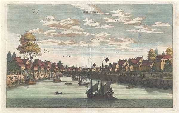
This is a 1670 Pieter van der Aa map or view of Tianjin, formerly romanized as Tientsin or Tiencienwey, China. The main focal point is the river, which dominates the center of the piece. Traditional Chinese Junks, an ancient kind of Chinese sailing ship, are anchored both in the middle of the river and along the left bank. Row boats appear to be ferrying people back and forth either between the various boats or between the boats and the riverbank. More masts are easily discernable that boats, as they stand in sharp contrast with the blue, cloud-dotted sky, but the ships blend in to the riverbank. Rather impressive looking houses line both banks of the river, most of which have two or three stories. A solitary tree is in evidence on the left bank, although other bushes and possible pine trees are discernable. More trees appear on the right bank, although these are all behind the houses. Several groups of birds fly across the sky, and people line the riverbank, possibly to say hello or goodbye to arriving or departing relatives/friends/neighbors, or to trade with the river-going merchants.
Created during the final stages of the Qing conquest of the Ming, this view comes from a time of transition. The Qing were the last imperial dynasty in China, and was the second conquest dynasty to rule all of China. By 1670, the violence and civil war had only recently ended in southern China. Although fighting would continue until 1683, when Taiwan fell and became a part of the Qing Empire.
This beautiful work was produced during the reign of the Kangxi Emperor, which lasted 61 years, the longest of any Chinese emperor, produced by Pieter van der Aa from notes taken by Johan Nieuhof during his adventures in China. The view was published in Van der Aa's Galerie Agreable du Monde.
CartographerS
Pieter van der Aa (1659 - 1733) was a Dutch publisher of maps and atlases active in the late 17th and early 18th centuries. Van der Aa was born in Leyden in 1659. At nine he was apprenticed to a local bookseller and, by 21, had established his own publishing, printing, and auctioneering house. In 1692 Van der Aa was appointed to be one of the High Commissioners of the Booksellers Guild. During his long and impressive career Van der Aa produced thousands of maps, including a vast 28 volume atlas containing no less than 3,000 maps. Few of Van der Aa's maps were original productions, most being copied from the work of earlier cartographers. Nonetheless, when one of Van der Aa's rare original pieces does appear, his style, with unusual projections, elegant engraving, and precise detail, is instantly recognizable and highly desirable. He also pioneered the cartographic idea of separating border artwork from the map plate itself such that every map in a collection could have a similar elaborate border without actually having to re-engrave the complex plates. This technique was used to great effect by later 18th century publishers like Brion de la Tour. Following Van der Aa's death in 1733, his much admired Nouvel Atlas was reissued by the Dutch firm of Covens & Mortier. Today Van der Aa's work is admired for its fine delicate engraving and unusual projections and is considered highly desirable among collectors. More by this mapmaker...
Johan Nieuhof (1618 - 1672) was a traveler and explorer with the Dutch East India Company. Born in Uelsen, a small town in Lower Saxony near the Dutch-German border, Nieuhof spent most of his life in Brazil, China and India. He is most famous for his written account of his journey from Canton to Peking in 1655-1657 called An embassy from the East-India Company of the United Provinces, to the Grand Tartar Cham, Emperor of China. The book, which improved European knowledge about China, also severed as a major influence for the growth of Chinoiserie, making Niefuhof an influential Western writer on China. While stationed in Ceylon, he was imprisoned for trading illegally in pearls and later fired from the Dutch East India Company. After a short family visit in 1672, on his way back to the East Indies, he stopped in Madagascar and traveled inland to trade with the local tribes as well as secure water for the crew, but never returned. The captain, after waiting three days, assumed that Nieuhof and his company were killed. Later, a ship was sent from the Cape of Good Hope to retrieve the party, but found no trace of Nieuhof or his company. Learn More...
Source
Van Der Aa, P., Galerie Agreable du Monde, (Leiden) 1723.
La Galerie agreable du Monde was monumental 66 part atlas published by Pieter van der Aa in Leiden from 1724 to 1729. It remains, to this day, the largest atlas ever published and possibly the costliest and comprehensive geographical work ever produced. The volume contained reissues of maps by Blaeu, Visscher, de Wit, Meurs, Halma, Mortier, Allard, in addition to Van der Aa's own maps prepared specifically for this atlas. Only 100 copies are known to have been produced, how many have survived is unknown, but this means that all of the unique maps from this important work are exceedingly scarce. It contained not only maps, but also illustrations and other engraving totaling over 4000 images.
Condition
Very good. Wear along original centerfold. Some repaired loss on verso. Blank on verso.
References
Rumsey 11647.017.