This item has been sold, but you can get on the Waitlist to be notified if another example becomes available, or purchase a digital scan.
1928 Peiyang Press City Plan or Map of Tientsin (Tianjin), China
Tientsin-peiyangpress-1928$600.00

Title
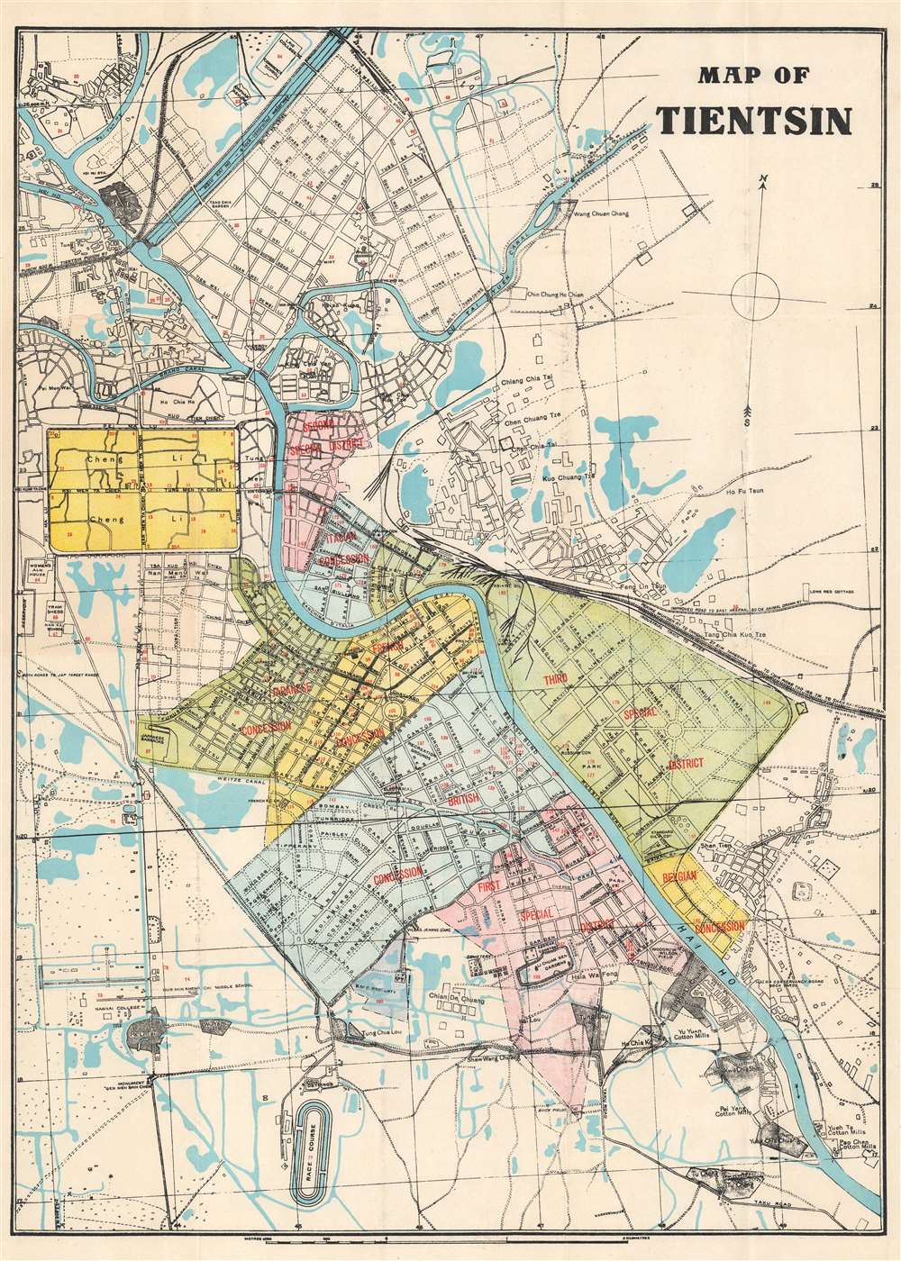
Map of Tientsin.
1928 (undated) 23.75 x 17.25 in (60.325 x 43.815 cm) 1 : 17500
1928 (undated) 23.75 x 17.25 in (60.325 x 43.815 cm) 1 : 17500
Description
This is a 1928 Peiyang Press city plan or map of Tientsin (天津市,Tianjin), China, shortly after the outbreak of the Chinese Civil War (1927 - 1849). Red overprinting identifies the British, French, Italian, Japanese, and Belgian concessions, along with the First, Second, and Third Special Districts. The same red overprinting marks 185 locations corresponding to an index. The Russian Consulate, French Consulate, British Consulate, Italian Consulate, Japanese Consulate, and U.S. Consulate are labeled within the Concessions and Special Areas. Other identified sites include Standard Oil's installation along the Hai Ho River, the Japanese Barracks, several gardens and parks, and Woodrow Wilson Field.
In the first half of the 20th century, due to Tianjin's special status as a Treaty Port, it avoided much of the violence associated with the Chinese Civil War (1927 - 1849) and various 'incidents' with Japan. The tenuous immunity began to fall apart on July 30, 1938, when Tianjin fell to Japan during Second Sino-Japanese War (1937 - 1945) and World War II (1939 - 1945). Even then, the Japanese largely respected the Concessions, who were not initially occupied. Finally, in 1941, as tensions with the west escalated, Imperial Japan occupied the American and British concessions.
Tientsin / Tianjin Concessions
Tianjin is a Chinese city strategically located at the intersection of the Grand Canal and the Peiho River - thus connecting Beijing to the Bohai Bay. Following the Second Opium War (1856 - 1860), the Treaty of Tientsin opened the city to Foreign Trade and the establishment of extraterritorial concessions. The British and French Tianjin Concessions opened in 1860. Between 1895 and 1900, Japan, Germany, Russia, Austria-Hungary, Italy, and Belgium - countries without concessions elsewhere in China - opened their own concessions. Foreign trade and investment led to Tianjin growing rapidly into one of China's most advanced and wealthiest cities.In the first half of the 20th century, due to Tianjin's special status as a Treaty Port, it avoided much of the violence associated with the Chinese Civil War (1927 - 1849) and various 'incidents' with Japan. The tenuous immunity began to fall apart on July 30, 1938, when Tianjin fell to Japan during Second Sino-Japanese War (1937 - 1945) and World War II (1939 - 1945). Even then, the Japanese largely respected the Concessions, who were not initially occupied. Finally, in 1941, as tensions with the west escalated, Imperial Japan occupied the American and British concessions.
Special Areas and Retrocessions
The map notes three 'Special Areas', former foreign concessions officially retroceded and/or seized by China. Following China's declaration of war on the Central Powers in 1917, Chinese forces occupied both the German and Austro-Hungarian concessions in Tianjin, terminating both extraterritorial leases. The German concession was placed under Chinese administration and formally renamed the 'First Special District' in 1919. Austria formally abandoned its extraterritorial claims in Tianjin on September 10, 1919, and Hungary did the same on June 4, 1920. The former Austro-Hungarian concessions were renamed the 'Second Special District'. The 'Third Special District' was once the Russian Concession. After the Communists took power in Russia, 1922, loyalist White Russians remained in control of the Tianjin. The new Soviet government renounced its extraterritorial claims in Tianjin in 1924 and the concession was renamed the 'Third Special District'.Publication History and Census
This map was created and published by Peiyang Press in 1928. We have been unable to locate any other cataloged examples of this edition, but a second edition was issued in 1941.Cartographer
The Peiyang Press (fl. c. 1928 – 1949) was a Chinese publisher active in Tianjin and Beijing before and during World War II. The press focused on books and maps for the western traveler in China, including works in English, German, and Dutch. It is likely that the press was owned and operated by ex-pat westerners, although we have no evidence to support this theory. Among these publications were British authors Alice Leighton Cleather and Basil Crump’s English-language book Buddhism: The Science of Life (2nd ed., 1928), Robert M. Duncan’s Peiping Municipality and the Diplomatic Quarter (1933), a Chinese-Dutch dictionary (1935) and a 1937 album of black and white photographs of British military exercises in China. They also issued a detailed city plan, Map of Tientsin, with editions published in at least 1928 and 1941. They are known to have published at least two influential pictorial maps in English during the 1930s, Frank Dorn's iconic A Map and History of Peiping and John Kirk Sewall's A Pictorial Map of Peiping. More by this mapmaker...
Condition
Very good. Exhibits light wear along original fold lines. Exhibits small area of infill in upper left quadrant.