This item has been sold, but you can get on the Waitlist to be notified if another example becomes available, or purchase a digital scan.
1901 French Map of Tianjin (Tientsin), China during the Boxer Rebellion
Tientsin-servicegeographique-1901$325.00

Title
Envrions de Tien-Tsin.
1901 (undated) 20.5 x 23.5 in (52.07 x 59.69 cm) 1 : 50000
1901 (undated) 20.5 x 23.5 in (52.07 x 59.69 cm) 1 : 50000
Description
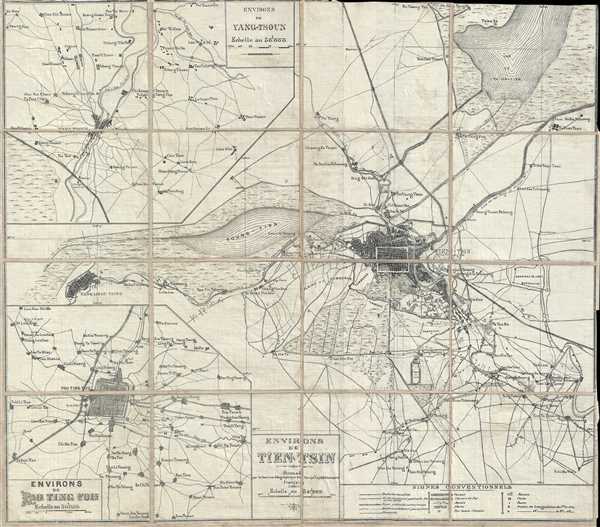
This is a 1901 French Service Géographique (Geographic Service) map of the region around Tianjin (Tientsin), China, during the Boxer Rebellion, particularly illustrating the region of deployment of the French Expeditionary Force. Tianjin is situated just to the right of center, with the city walls and streets clearly visible. In the surrounding region, numerous towns and villages are labeled, along with the 'Plain of Tombs'. A key is located in the lower right corner, allowing the user to identify canals, roads, railroads, and various features of the landscape, such as marshes. Two inset maps are illustrated as well: the environs around Pao Ting Fou and Yang-Tsoun. Each of these inset maps includes the same notations as the central map, including numerous labeled villages, roads, canals, and railroads.
The Boxer Rebellion or Yihetuan Movement was an anti-foreign anti-imperialist uprising marked by proto-nationalism in northeastern China. The rebellion was largely a response to Christian missionary activity in China and was initially supported by the Qing Empress Dowager Cixi. In June of 1900 the quasi-spiritual Boxers, convinced they were immune to foreign weapons, attacked the Chinese Christians and foreigners living in Beijing's Legation Quarter. Although many killings ensued the legations were able to prepare a tenuous defense and found themselves besieged. Relief came quickly in the form of the Eight-National Alliance, which, with an army of some 20,000, defeated the Boxers and occupied Beijing, as well as a number of other northern Chinese cities. The atrocities and looting that ensued, particularly at the hands of Russian and Japanese forces, are well documented and horrifying.
This map depicts the regions where the French Expeditionary Force was stationed. In late 1900, it was decided that allied troops should occupy the Tombs of the Emperors (labeled here as 'tombeaux' and 'Plaine de Tombeaux') to hasten negotiations. Thus, a column of French troops was dispatched from Pao-Ting-Fou. French troops were stationed in Beijing (Peking), Tianjin (Tientsin), and Pao-Ting-Fou.
This map was created by the Service Géographique du Corps Expéditionnaire Français in 1901.
Condition
Very good. Dissected and mounted on linen in 16 panels. Close margins. Blank on verso.