1895 Hourst / Bluzet Map of Timbuktu and Environs, Mali
Timbuktu-hourst-1895$450.00

Title
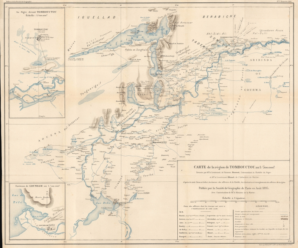
Carte de la région de Tombouctou au 1/500.000e.
1895 (dated) 19.25 x 23.25 in (48.895 x 59.055 cm) 1 : 500000
1895 (dated) 19.25 x 23.25 in (48.895 x 59.055 cm) 1 : 500000
Description
This highly detailed map of the Niger River, Timbuktu, and environs - one of the first to offer the European audience any real information on the fabled desert 'city of gold'. It was prepared by Lieutenants Hourst and Bluzet and published in the 1895 Bulletin de la Société de Géographie. Hourst was the leader of an ambitious French expedition to descend along the Niger River from Timbuktu to the Atlantic Ocean,
It was only at the turn of the 19th century that Europeans managed to reach this general area, with the daring Scottish adventurer Mungo Park (1771 - 1806) traversing most of the course of the Niger River but never reaching Timbuktu due to conflicts with locals. The first European to reach the city was Alexander Gordon Laing (1794 - 1826), though he was murdered just after leaving. Two years later, Frenchman René Caillié reached Timbuktu (on an expedition financed by the Société de Géographie) and lived to tell the story - though the story he told, of a ramshackle, dusty town dominated by camels more than people, greatly disappointed Europeans hoping to discover a lost golden city. Nevertheless, even after the travels of Caillié and other Europeans, detailed geographic knowledge of this region remained limited throughout the 19th century.
A Closer Look
This map was prepared as a result of an 1894 - 1898 expedition along the full course of the Niger River led by flotilla commander Emile-Auguste-Léon Hourst (1864 - 1940). This expedition occurred just after the 1892 incorporation of Mali into the French Empire (part of 'Soudan français') and the 1893 French military occupation of Timbuktu. The map covers from the uniquely-shaped Lake Faguibine and Timbuktu in the north to Lake Débo in the south. Waterways of various sorts, many of which are seasonal, are traced in detail. Settlements are also recorded, including those with a French garrison, marked with a French tricolore, as are local ethnic groups. The locations of recent battles are also marked with crossed swords - although some groups readily aligned with the French to overpower local rivals, others resisted until the early 20th century. Two inset maps appear, depicting the immediate vicinity of Timbuktu and Goundam on Tele Lake, respectively. A legend and full list of the map's contributors appears at bottom-right.Seeking Mansa Musa's 'City of Gold'
This map charts the course of the Upper Niger River, the longest river in Africa after the Nile and the Congo. Beginning near the border of Guinea and Sierra Leone, the river winds in a long arc towards the Sahara (the top of the arc seen here) and then down through Niger and Nigeria, where it flows out to the Atlantic. The region seen here is important, among other reasons, for containing the ancient city of Timbuktu, which had become fabulously wealthy in the late Medieval and Renaissance periods of European history. As Europeans were beginning their extracontinental explorations, they became entranced, even obsessed, with finding the fabled 'city of gold,' but its location deep in the African interior and across the inhospitable Sahara made it effectively inaccessible.It was only at the turn of the 19th century that Europeans managed to reach this general area, with the daring Scottish adventurer Mungo Park (1771 - 1806) traversing most of the course of the Niger River but never reaching Timbuktu due to conflicts with locals. The first European to reach the city was Alexander Gordon Laing (1794 - 1826), though he was murdered just after leaving. Two years later, Frenchman René Caillié reached Timbuktu (on an expedition financed by the Société de Géographie) and lived to tell the story - though the story he told, of a ramshackle, dusty town dominated by camels more than people, greatly disappointed Europeans hoping to discover a lost golden city. Nevertheless, even after the travels of Caillié and other Europeans, detailed geographic knowledge of this region remained limited throughout the 19th century.
Publication History and Census
This map was prepared by Emile-Auguste-Léon Hourst and René Bluzet (1871 - 1915), French naval officers. It was engraved by Erhard Frères, and published by the Société de Geographic de Paris in the third issue of the 1895 Bulletin de la Société de Géographie. This issue of the Bulletin included an article by Bluzet (La Région de Tombouctou) describing the expedition's explorations in this area (Hourst later wrote up a full account of the expedition, La mission Hourst, sur le Niger et au pays des touaregs, which was also translated into English). The map is independently cataloged by the University of Chicago Library, Bibliothèque nationale de France, and Staatsbibliothek zu Berlin, while the entire issue and volume are more widespread in institutional collections.Cartographer
Georges Erhard Schièble (1823 – November 23, 1880) was a German printer active in Paris during the middle to late 19th century. Erhard was born in Forchheim, Baden-Württemberg, and relocated to Paris in his 16th year, where he apprenticed under his cousin, an engraver and mapmaker. In 1852, after 6 years with the Royal Printing Office, he started his own business. Around this time, he also became a naturalized French citizen. From his offices on Rue Bonaparte, he produced several important maps, and a detailed topography of Gaul for Napoleon III's History of Julius Caesar. In 1865 he took on larger offices expanding his operations to include a lithographic press. He was among the first to introduce printed color maps and pioneered photo-reduction, including the process known as Erhard reproduction. After Erhard's death in 1880, the firm was taken over by his sons and run under the imprint of 'Erhard Frères' until 1911. More by this mapmaker...
Condition
Very good. Some wear on old fold lines.
References
OCLC 557694690, 494191362.