1889 French Bureau Topographique Map of Tonkin, Vietnam, Indochina
Tonkin-bureautopographique-1889$750.00

Title
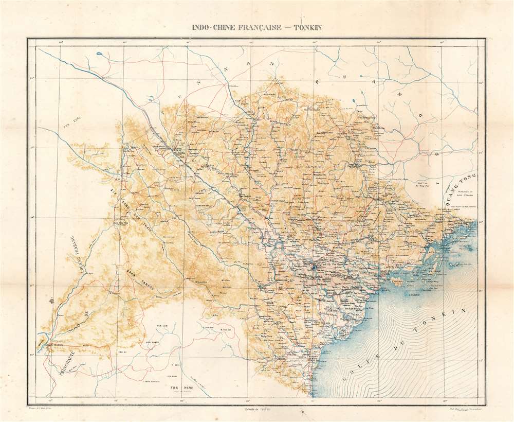
Indo-Chine Française - Tonkin.
1889 (dated) 23 x 27 in (58.42 x 68.58 cm) 1 : 1000000
1889 (dated) 23 x 27 in (58.42 x 68.58 cm) 1 : 1000000
Description
This is an 1889 French Bureau Topographique des Troupes de l'Indo-Chine map of Tonkin, Vietnam, or North Vietnam.
A Closer Look
Impressive detail is offered throughout. Not only are cities, such as Hanoi and Haiphong, labeled, but towns and villages are identified as well. The river network is illustrated with precision, and the road network is highlighted in red. All the details likely reflect the fact that the French had been fighting an increasingly violent insurgency in Tonkin since 1882. The French then fought a war with China, the Sino-French War (1884 - 1885). Afterward, with Chinese support, the insurgency continued to undermine French colonial power.Getting the Upper Hand on the Insurgency
In 1889, the French had been waging an ineffective counterinsurgency for the previous three years. It was not until 1891, when Jean-Marie de Lanessan (the newly appointed governor-general of Tonkin) introduced innovative military strategies, that French forces began to gain ground. He created structures that allowed military commanders to contain and defeat the insurrection and appointed officers capable of accomplishing their assigned goals. Two of these men, Joseph Gallieni and Hubert Lyautey, would distinguish themselves in World War I (1914 - 1918) and retire as Marshals of France. Then, the French embarked on a policy of winning the Vietnamese hearts by proving that French occupation was preferable to anarchy. Gradually, the Vietnamese peasants turned their backs on the insurgents, and without the support of the population, the insurgency dissolved.Publication History and Census
This map was created and published by the Bureau Topographique des Troupes de l'Indo-Chine in 1889. It is uncataloged in OCLC, and we have been unable to trace any other examples.Cartographer
Bureau Topographique des Troupes de l'Indo-chine (fl. c. 1886 - 1900) was founded in 1886 in Hanoi. Its first major project was a 1:2000000 map of the entirety of Indochina, for which they drew on source maps created by the Service Hydrographique de la Marine and those created by an expeditionary corps sent throughout the region. Before establishing its own printing facilities in Indochina in 1890, the Bureau Topographique transferred their work back to Paris to be printed by the Service Géographique de l'Armée. In 1890 the Bureau Topographique also began to increase its cartographic output. The Bureau Topographique sent army officers on triangulation and topographic missions in unexplored areas of Indochina throughout the 1890s, some of which proved fatal for the participants. It is unclear when the Bureau Topographique shut down, but no examples of their work postdate 1900. More by this mapmaker...
Condition
Good. Exhibits wear and toning along original fold lines. Closed vertical tears along original a fold line professionally repaired on verso. Verso repairs to fold separations.