This item has been sold, but you can get on the Waitlist to be notified if another example becomes available, or purchase a digital scan.
1750 Bellin Map of Tonkin River, Vietnam
TonkinRiver-bellin-1750$100.00

Title
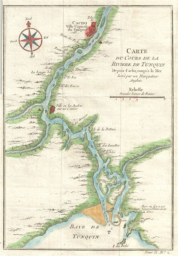
Carte Du Cours De La Riviere De Tonquin Depuis Cacho jusqu'a la Mer, Levee par un Navigateur Anglois.
c. 1750 (undated) 8.75 x 6 in (22.225 x 15.24 cm)
c. 1750 (undated) 8.75 x 6 in (22.225 x 15.24 cm)
Description
Laden with reddish silt, the Red River, once known as the 'River of Tonkin,' begins in China and forms part of Vietnam's border with China before turning south to pass Hanoi and empty into the Gulf of Tonkin. Both river and gulf derive their nomenclature from the former Kingdom of Tonkin (Tonquin), modern North Vietnam. Though the river floods violently, its delta is an important agricultural area.
In the 1700s the country was under the nominal rule of the Le Dynasty, but real power lay in the hands of two warring feudal families, the Trinh Lords of the north, and the Nguyen Lords in the south. Aside from fighting the Trinhs, the Nguyens engaged frequent wars of conquest with the neighboring Khmers and the powerful Siam. With help from their French allies, they were often victorious, winning new lands and titles. However, the desperately poor peasant farmers who formed the majority of the population continued to suffer under the corrupt and oppressive government. Conditions were ripe for a colonialist incursion. In the late 19th century european belief grew that the river offered a lucrative trade route to China. France invaded Vietnam to take control of the Tonkin River, victoriously folding the country into French Indochina in 1886.
Drawn by Jacques Nicolas Bellin and published as plate no. 2 in volume 9 of the 1752 French edition of Abbe Provost's L'Histoire Generale des Voyages.
Cartographer
Jacques-Nicolas Bellin (1703 - March 21, 1772) was one of the most important cartographers of the 18th century. With a career spanning some 50 years, Bellin is best understood as geographe de cabinet and transitional mapmaker spanning the gap between 18th and early-19th century cartographic styles. His long career as Hydrographer and Ingénieur Hydrographe at the French Dépôt des cartes et plans de la Marine resulted in hundreds of high quality nautical charts of practically everywhere in the world. A true child of the Enlightenment Era, Bellin's work focuses on function and accuracy tending in the process to be less decorative than the earlier 17th and 18th century cartographic work. Unlike many of his contemporaries, Bellin was always careful to cite his references and his scholarly corpus consists of over 1400 articles on geography prepared for Diderot's Encyclopedie. Bellin, despite his extraordinary success, may not have enjoyed his work, which is described as "long, unpleasant, and hard." In addition to numerous maps and charts published during his lifetime, many of Bellin's maps were updated (or not) and published posthumously. He was succeeded as Ingénieur Hydrographe by his student, also a prolific and influential cartographer, Rigobert Bonne. More by this mapmaker...
Source
Prévost, A., Histoire Générale des Voyages, ou Nouvelle Collection de Toutes les Relations de Voyages par Mer et par Terre..., (Paris: Didot) 1746 - 1759, Supplements 1761 - 1801.
Prévost's Histoire Générale des Voyages is a 15-volume compendium of travel literature initiated by Antoine François Prévost (Provost; 1697 - 1763) in 1746, intended as a universal history of exploration and geography. The initial publication, compiled from 1746 to 1759, spans 15 volumes and draws from a vast array of sources - travelers, explorers, missionaries, merchants, and diplomats - to present detailed narratives of significant global journeys. The work was initially published in Paris by Didot and offers ethnographic, political, religious, and natural observations about the peoples, cultures, flora, fauna, and geography. It is an ambitious attempt to organize knowledge about the world's diversity according to Enlightenment values, reflecting both scientific curiosity and imperial ideology. It functioned as both an informative reference and a literary work, influencing how European audiences understood and imagined distant lands. It proved extremely successful, and both reissues other publishers and pirate editions emerged, most notably Pierre de Hondt's 1747 Dutch edition and Jean-Franćois de la Harpe's 1780 abridged version. In addition to reissues of the original work, between 1768 and 1801, additional expanded volumes emerged, adding new voyages and histories. We have seen some sets with as many as 80 volumes. Over time, the Histoire générale des voyages became one of the most comprehensive and widely read travel collections of the 18th century, notable for blending factual reporting with the period's characteristic intellectual ambition.
Condition
Very good. Original fold lines. Blank on verso.