This item has been sold, but you can get on the Waitlist to be notified if another example becomes available, or purchase a digital scan.
1928 NHA Map of the Trans-Canada Highway: highway propaganda!
TransCanadaHighway-nha-1928$475.00

Title
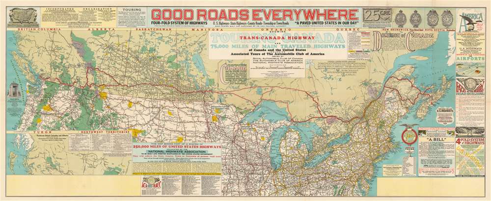
Good Roads Everywhere. Trans-Canada Highway.
1926 (dated) 22 x 50.5 in (55.88 x 128.27 cm) 1 : 3760000
1926 (dated) 22 x 50.5 in (55.88 x 128.27 cm) 1 : 3760000
Description
A scarce, large, and strikingly dense 1928 National Highways Association persuasive map of the southern Canada prepared to promote investment in a Canadian national highway system. Entitled 'Good Roads Everywhere' the map was is a modified version of a similar map issued in 1926 to promote highways in the United States. The map covers southern Canada and the northern part of the United States from Coast to Coast. Highways are illustrated with color coding defining the 75,000 miles of Canadian highways advocated for by the National Highway Association.
Trans-Canada Highway
The highlight of this map is a proposed Trans-Canada Highway linking Halifax with Vancouver. though construction was not actually authorized until 1949. Advocates for the Trans-Canada highway began issuing propagand from the late 1920s (as here), but the government was slow to adopt the idea. It was until 1949 when the Trans-Canada Highway Act passed parliament, the construction began. Taking roughly 12 years, the work was completed in 1971, at which point the road was the longest uninterrupted highway in the world. The present map shows a combination of existing and proposed roads. New construction was required to link Hope and Princeton in British Columbia, and Elma with Cochrane with Sault Ste. Marie in Ontario. The map also calls for a Ferry transfer on Kootenay Lake (mislabeled here as Lower Arrow Lake) between Nelson and Kushonook, Alberta.Publication History and Census
This map was prepared by John C. Mulford and C. C. Faunce. The first edition appeared, as here, in 1928. The present example, issued in 1926, is the 13th edition, issued for the 73rd annual meeting of the American Society of Civil Engineers, held in New York City in January of 1926. All editions were issued jointly by the Automobile Club of America and the National Highways Association. It is unclear to what extent this was circulated or was even put into production. Most known examples feature large blank areas in the lower left and right quadrants - suggesting placement reserved for advertising - leading us to believe that all surviving examples are merely production copies. Unlike the U.S. edition, there appears to be but one edition/state here. The OCLC identifies 3 examples in institutional collections, held at the Massachusetts State Library, The Osher Map Library, and at the University of Chicago.CartographerS
John Cheeseman Mulford (April 27, 1876 - March 15, 1933) was an American cartographer active in the early to middle 20th century. He was born in Winnetka, Illinois. As early as 1918, Mulford worked in the drafting section of the Washington D.C. office of the Bureau of Reclamation, a federal water resource management agency. Mulford was later the chief cartographer of the National Highways Association (NHA). He played a significant role in mapping the early development of the American highway system. Mulford died in Maryland in 1933. More by this mapmaker...
August Hoen and Company (fl. c. 1840 - 1981) was a Baltimore based engraving and lithography firm active in the middle part of the 19th century. A. Hoen and Co. was originally founded by Edward Weber under the name 'E. Weber and Company.' Weber died in the early 1850s and his company was taken over by German immigrant August Hoen (18?? - 1886) and his brothers, Henry and Ernest Hoen. As general interest lithographers, the Hoen firm's corpus includes posters, cigar boxes, sheet music covers, and posters as well as maps. They are best known for their pioneering multi-color lithographic techniques. After the death of August Hoen, the business passed on to his son, Albert Hoen. Another son, Earnest A. Hoen, moved to Richmond, Virginia and opened a branch of the firm there where he was granted a charter to produce Civil War era Confederate Currency. Their contributions to the cartographic field are generally in association with engraving and printing work done for Jacob Monk and the U.S. Geological Survey. The Hoen family maintained an active interest in the firm for the next 100 years or so until it finally filed for bankruptcy in 1981. Learn More...
Condition
Good. Light wear and verso reinforcement as some fold intersections.
References
OCLC 39690810.