This item has been sold, but you can get on the Waitlist to be notified if another example becomes available, or purchase a digital scan.
1871 Colton Map of the Proposed Transpacific Telegraph Cable
TransPacificTelegraph-colton-1871$175.00

Title
Route of Mr. Cyrus W. Field's Proposed Cable Between the US and China.
1871 (undated) 6.5 x 11 in (16.51 x 27.94 cm) 1 : 75000000
1871 (undated) 6.5 x 11 in (16.51 x 27.94 cm) 1 : 75000000
Description
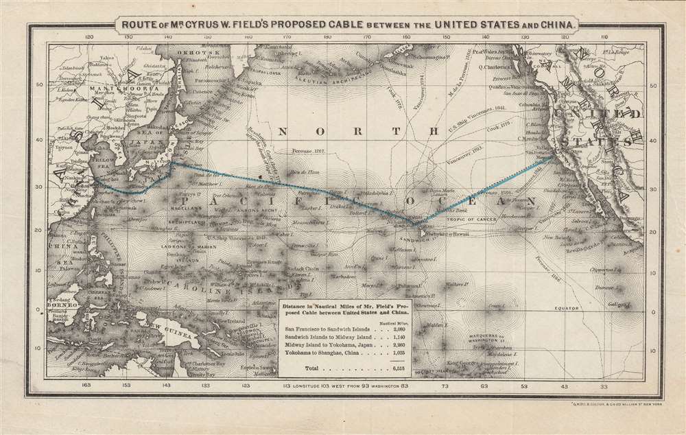
This is a fascinating c. 1871 G.W. and C.B. Colton map of a proposed telegraph cable across the Pacific Ocean. This map was produced in the wake of a speech to the U.S. Congress by Cyrus W. Field in May 1870 promoting a Transpacific cable. Although an important global infrastructure link, the Transpacific cable was beset by financing and technical difficulties meant that it would be thirty years before the project was realized.
Though no legend is provided, the solid lines in North America refer to existing telegraph lines, while dashed lines highlight proposed lines connecting Russia, East Asia, and Australia. The proposed cable through Siberia was meant to eventually cross the Bering Strait and link up with an overland cable from British Columbia, but despite securing financing and beginning work, the Russian-American Telegraph was never completed, in large part as Field's proposal came to be seen as more realistic.
Nevertheless, Field was a dedicated evangelist of telegraphy, and spent the next decade raising new capital and preparing for a second cable, which in reality was mostly a matter of repairing and improving the first cable. This effort succeeded in 1866 and, while still slow and prone to hiccups, the second cable functioned much better than its predecessor. In the 1870s, additional improvements were made and more cables laid, making Transatlantic telegraphy a reliable means of communication.
Despite his ultimate success with the Atlantic cable, Field's notion of laying a cable across the Pacific was an even more daunting task. The distances involved were much greater, the contours and depth of the seabed not as well understood, and the economic logic behind it was not as compelling. For these reasons, Field's proposal elicited interest but not much in the way of financing or concrete plans.
Finally, in the closing years of the 19th century, momentum built for laying a Transpacific cable, with the British 'All-Red Line,' linking Vancouver to Australia and thus completing a global telegraph circuit, taking an early lead. However, the British line was not completed until 1911, in part due to redundancy; Australia was by then already well-connected with the rest of the empire via India. In the meantime, the Commercial Pacific Cable Company was founded in the wake of the Spanish-American War (1899 - 1900) and quickly laid a line from San Francisco to Honolulu that became operational in 1903. By the end of that year, the cable reached Manila, and by 1906 the line connected with Japan and Shanghai. Thus, while Field's original 1870 proposal was not far off the mark, the impetus and exact course of the cable was ultimately dictated by America's imperial acquisitions in the Pacific.
A Closer Look
The Pacific Ocean and surrounding lands are depicted, with an emphasis on small islands that might play an outsize role in the development of any telegraph lines. The proposed line from San Francisco to Shanghai, via Hawaii and Yokohama, is displayed prominently in blue, with a corresponding table at bottom noting distances. The travels of explorers around the Pacific (Perouse, Cook, Vancouver, etc.) are also tracked.Though no legend is provided, the solid lines in North America refer to existing telegraph lines, while dashed lines highlight proposed lines connecting Russia, East Asia, and Australia. The proposed cable through Siberia was meant to eventually cross the Bering Strait and link up with an overland cable from British Columbia, but despite securing financing and beginning work, the Russian-American Telegraph was never completed, in large part as Field's proposal came to be seen as more realistic.
Cyrus West Field and the Pacific Cable
Cyrus W. Field a, along with a group of New York industrialists and Samuel F. B. Morse, with whom he later clashed, was the driving force behind the Transatlantic cable, laid between 1854 and 1858 by the Atlantic Telegraph Company. Although a pioneering feat in its audaciousness, the Transatlantic cable was plagued with difficulties from its 1858 inception, becoming inoperable after only three weeks. This was in part because Field had no special technical expertise with communications equipment. But even among the technical experts, namely William Thomson and Wildman Whitehouse, there was considerable disagreement as to how to fix the issues.Nevertheless, Field was a dedicated evangelist of telegraphy, and spent the next decade raising new capital and preparing for a second cable, which in reality was mostly a matter of repairing and improving the first cable. This effort succeeded in 1866 and, while still slow and prone to hiccups, the second cable functioned much better than its predecessor. In the 1870s, additional improvements were made and more cables laid, making Transatlantic telegraphy a reliable means of communication.
Despite his ultimate success with the Atlantic cable, Field's notion of laying a cable across the Pacific was an even more daunting task. The distances involved were much greater, the contours and depth of the seabed not as well understood, and the economic logic behind it was not as compelling. For these reasons, Field's proposal elicited interest but not much in the way of financing or concrete plans.
Finally, in the closing years of the 19th century, momentum built for laying a Transpacific cable, with the British 'All-Red Line,' linking Vancouver to Australia and thus completing a global telegraph circuit, taking an early lead. However, the British line was not completed until 1911, in part due to redundancy; Australia was by then already well-connected with the rest of the empire via India. In the meantime, the Commercial Pacific Cable Company was founded in the wake of the Spanish-American War (1899 - 1900) and quickly laid a line from San Francisco to Honolulu that became operational in 1903. By the end of that year, the cable reached Manila, and by 1906 the line connected with Japan and Shanghai. Thus, while Field's original 1870 proposal was not far off the mark, the impetus and exact course of the cable was ultimately dictated by America's imperial acquisitions in the Pacific.
Publication History and Census
This map was produced by G.W. and C.B. Colton in New York, most likely in 1870 or 1871. It is closely related to a contemporary map published by the Coltons demonstrating existing and proposed global telegraph lines (worldtelegraphlines-colton-1871). The only other known example of the present map is held among the Cyrus W. Field Papers at the Smithsonian Institution.Cartographer
Joseph Hutchins Colton (July 5, 1800 - July 29, 1893), often publishing as J. H. Colton, was an important American map and atlas publisher active from 1833 to 1897. Colton's firm arose from humble beginnings when he moved to New York in 1831 and befriended the established engraver, Samuel Stiles. He worked under Stiles as the 'Co.' in Stiles and Co. from 1833 to 1836. Colton quickly recognized an emerging market in railroad maps and immigrant guides. Not a cartographer or engraver himself, Colton's initial business practice mostly involved purchasing the copyrights of other cartographers, most notably David H. Burr, and reissuing them with updated engraving and border work. His first maps, produced in 1833, were based on earlier Burr maps and depicted New York State and New York City. Between 1833 and 1855, Colton proceeded to publish a large corpus of guidebooks and railroad maps, which proved popular. In the early 1850s, Colton brought his two sons, George Woolworth Colton (1827 - 1901) and Charles B. Colton (1832 - 1916), into the map business. G. W. Colton, trained as a cartographer and engraver, was particularly inspired by the idea of creating a large and detailed world atlas to compete with established European firms for the U.S. market. In 1855, G.W. Colton issued volume one of the impressive two-volume Colton's Atlas of the World. Volume two followed a year later. Possibly because of the expense of purchasing a two-volume atlas set, the sales of the Atlas of the World did not meet Colton's expectations, and so, in 1856, the firm also issued the atlas as a single volume. The maps contained in this superb work were all original engravings, and most bear an 1855 copyright. All of the maps were surrounded by an attractive spiral motif border that would become a hallmark of Colton's atlas maps well into the 1880s. In 1857, the slightly smaller Colton's General Atlas replaced the Atlas of the World. Most early editions of the General Atlas published from 1857 to 1859 do not have the trademark Colton spiral border, which was removed to allow the maps to fit into a smaller format volume. Their customers must have missed the border because it was reinstated in 1860 and remained in all subsequent publications of the atlas. There were also darker times ahead; in 1858, Colton was commissioned at a sum of 25,000 USD by the government of Bolivia to produce and deliver 10,000 copies of a large format map of that country. Although Colton completed the contract in good faith, delivering the maps at his own expense, he was never paid by Bolivia, which was at the time in the midst of a series of national revolutions. Colton would spend the remainder of his days fighting with the Bolivian and Peruvian governments over this payment, and in the end, after a congressional intervention, he received as much as 100,000 USD in compensation. Nonetheless, at the time, it was a disastrous blow. J. H. Colton and Company is listed as one of New York's failed companies in the postal record of 1859. This led Colton into the arms of Alvin Jewett Johnson and Ross C. Browning. The 1859 edition of Colton's General Atlas lists Johnson and Browning as the 'Successor's to J. H. Colton' suggesting an outright buyout, but given that both companies continued to publish separately, the reality is likely more complex. Whatever the case may have been, this arrangement gave Johnson and Browning access to many of Colton's map plates and gave birth to Johnson's New Illustrated (Steel Plate) Family Atlas. The Johnson's Atlas was published parallel to Colton's atlases well into the 1880s. The Colton firm itself subsequently published several other atlases including an Atlas of America, the Illustrated Cabinet Atlas, the Octavo Atlas of the Union, and Colton's Quarto Atlas of the World. They also published a large corpus of wall maps, pocket maps, and guides. The last known publications of the Colton firm date to 1897 and include a map and a view, both issued in association with the Merchant's Association of New York. Alice M. Colton married August R. Ohman (May 3, 1859 - April 22, 1934) on January 5, 1897. In 1898, Ohman joined the Colton firm, which continued to publish as Colton, Ohman & Co. until 1901. More by this mapmaker...
Condition
Very good. Light foxing at top margin.
References
Jeffrey K. Lyons, 'The Pacific Cable, Hawai'i, and Global Communication,' The Hawaiian Journal of History, Volume 39, 2005.