This item has been sold, but you can get on the Waitlist to be notified if another example becomes available, or purchase a digital scan.
1913 Travelers Insurance Company Map of the Mexican Revolution
TravelersInsuranceMexico-travelers-1913-2$375.00


Title
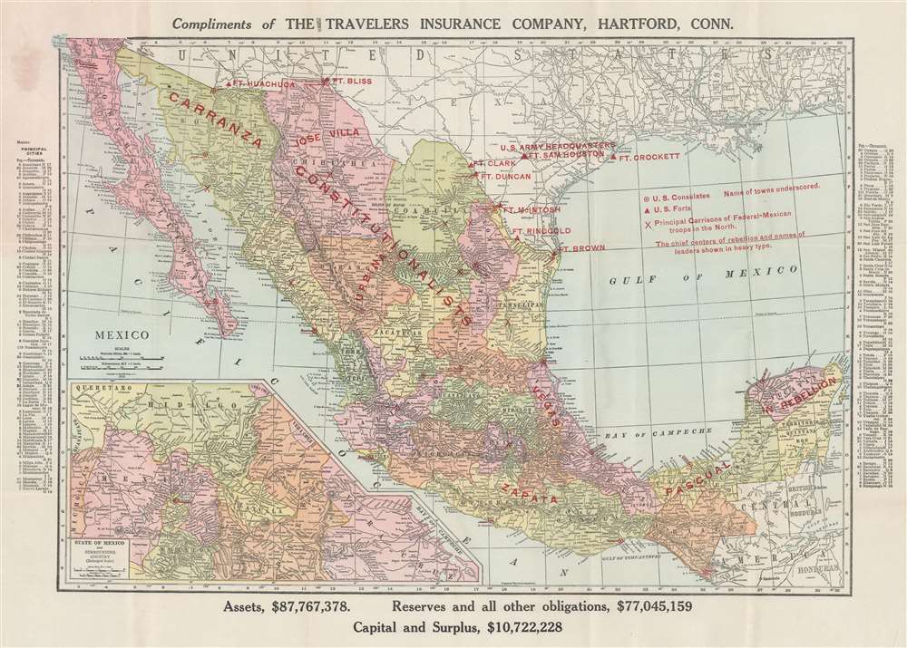
Compliments of The Travelers Insurance Company, Hartford, Conn.
1913 (dated) 15.25 x 21.25 in (38.735 x 53.975 cm) 1 : 6209280
1913 (dated) 15.25 x 21.25 in (38.735 x 53.975 cm) 1 : 6209280
Description
This is a 1913 Travelers Insurance Company and Rand McNally map of Mexico during the Mexican Revolution (1910 - 1920). The map, intended for American customers of Travelers, was meant to assure investors that their insured assets in Revolutionary Mexico were protected. Coverage extends from the Pacific Ocean to the Atlantic Ocean and from the southern United States to Guatemala, Honduras, and the Gulf of Tehuantepec. The situation in Mexico is presented by using red overprinting identifying which factions controlled various parts of Mexico. Areas controlled by Venustiano Carranza, Jose 'Poncho' Villa, and Emiliano Zapata, all important figures in the Mexican revolution, are labeled, as are all the garrisons of Mexican federal troops. U.S. forts along the U.S.-Mexico border are also highlighted using the red overprinting, reinforcing the notion that the United States was protected against the chaos to its south. As this is a Rand McNally map, myriad cities, towns, and villages are labeled and the principal cities are underscored in red. An inset map of Mexico City and its environs is situated in the lower left.
The Mexican Revolution until 1913
Foreign investment in Mexico flourished during The Porfiriato, a period of Mexican history from 1876 – 1911 dominated by General Porfirio Díaz. While he was in power, Díaz believed that it was necessary to suppress opposition and maintain order to reassure foreign entrepreneurs that investing in Mexico was safe. The Mexican Revolution ignited because it was unclear who would succeed Díaz. By the summer of 1913, Francisco Madero had been elected president, but he abandoned most of the popular rhetoric that elected him. Instead of nurturing the support of fellow revolutionaries, with whom he had ousted Porfirio Díaz, Madero was bound by the Treaty of Ciudad Juarez, which guaranteed that the essential structure of the Díaz regime remained in place. This meant that, instead of employing the revolutionary armies, they were sent home and Madero utilized the Federal Army to keep peace. This, and his choice not to maintain important policies concerning land reform, led to the resumption of insurrections led by Zapata and Pascual Orozco. This map reflects this situation: a new president, Madero, finding himself on the opposite side of the revolutionaries. Madero resigned late in 1913, but was murdered along with his vice president on their way to prison.Publication History and Census
This map was originally designed and printed by Rand McNally and then repurposed by the Travelers Insurance Company as a broadside advertisement concerning the Mexican Revolution in 1913. While well represented in institutional collections, it is very scarce on the private market, with only three other known examples entering the private market in the last fourteen years.Cartographer
Rand, McNally and Co. (fl. 1856 - present) is an American publisher of maps, atlases and globes. The company was founded in 1856 when William H. Rand, a native of Quincy, Massachusetts, opened a print shop in Chicago. Rand hired the recent Irish immigrant Andrew McNally to assist in the shop giving him a wage of 9 USD per week. The duo landed several important contracts, including the Tribune's (later renamed the Chicago Tribune) printing operation. In 1872, Rand McNally produced its first map, a railroad guide, using a new cost effective printing technique known as wax process engraving. As Chicago developed as a railway hub, the Rand firm, now incorporated as Rand McNally, began producing a wide array of railroad maps and guides. Over time, the firm expanded into atlases, globes, educational material, and general literature. By embracing the wax engraving process, Rand McNally was able to dominate the map and atlas market, pushing more traditional American lithographic publishers like Colton, Johnson, and Mitchell out of business. Eventually Rand McNally opened an annex office in New York City headed by Caleb S. Hammond, whose name is today synonymous with maps and atlases, and who later started his own map company, C. S. Hammond & Co. Both firms remain in business. More by this mapmaker...
Condition
Very good. Verso repair to a fold separation. Attached to original binder.
References
OCLC 28653932.