This item has been sold, but you can get on the Waitlist to be notified if another example becomes available, or purchase a digital scan.
1801 Manuscript Map of Tribeca, New York City
Tribeca-loss-1801$1,750.00

Title
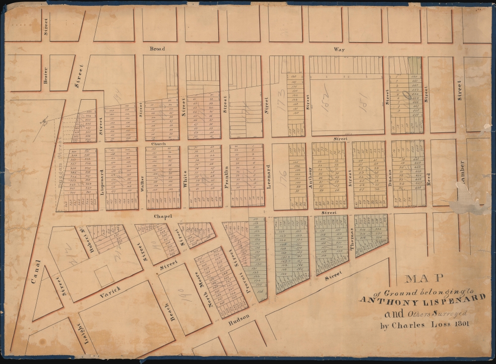
Map of Ground belonging to Anthony Lispenard and Others Surveyed by Charles Loss 1801.
1801 (dated) 21.5 x 29.5 in (54.61 x 74.93 cm) 1 : 1290
1801 (dated) 21.5 x 29.5 in (54.61 x 74.93 cm) 1 : 1290
Description
This unique c. 1803 manuscript is likely the earliest surviving specific map to detail modern-day Tribeca, New York City. The map is oriented to the east, with coverage extending from Canal Street to Chambers Street and from Broadway to Hudson Street. These were lands owned by Anthony Lispenard Bleecker (1741 - 1816).
The street layout of Tribeca was roughly put together in the late 1700s, but little development occurred. A square on Varick between Laight and Beach marks the location of St. John's Chapel, constructed in 1803. That the chapel is only ghosted in here suggests it was still under construction or not yet built when this map was made. Illustrations of the area from the early 19th century reveal open tree-filled lands on all sides. Most of the subsequent construction in this region followed the 1811 filling of Collect Pond.
A Nice Country Estate
Bleeker acquired this property in 1801, during which time he was a prominent banker, merchant, and auctioneer, and one of the richest men in New York. According to the 1884 obituary of his grandson Anthony J. Bleeker, he remembers his grandfather returning home one day and proudly announcing he acquired some 160 acres 'out in the country.' That vast tract of land eventually evolved into the modern-day neighborhoods of Tribeca and Greenwich Village. Here, Anthony Street (modern-day Worth St.) is named after him, as is Lispenard, which retains the name.The street layout of Tribeca was roughly put together in the late 1700s, but little development occurred. A square on Varick between Laight and Beach marks the location of St. John's Chapel, constructed in 1803. That the chapel is only ghosted in here suggests it was still under construction or not yet built when this map was made. Illustrations of the area from the early 19th century reveal open tree-filled lands on all sides. Most of the subsequent construction in this region followed the 1811 filling of Collect Pond.
Duggan Street, Collect Pond, Five Points
A proposed street, Duggan, is ghosted in over Canal and is named after another wealthy landowner, Thomas Duggan. The street was proposed in the early 1800s but never materialized (largely because this area was nearly uninhabitable due to quagmire-like conditions), but its presence here helps date the map. It is located just west of the former site of Collect Pond, a natural drainage pond that, by the early 19th century, had become little more than a cesspool. In 1811, the pond was filled with debris leveling nearby Bayard's Mount and Kalck Hoek. While initially considered sufficient for middle-class housing, the haphazard fill began to settle, and most buildings constructed there had flooding and foundational problems. By the 1820s, it was well on its way to becoming one of the world's most notorious slums - the Five Points.Publication History and Census
Unique manuscript. Only known example.Cartographer
Charles F. Loss (1765 - 1822) was a New York City surveyor active in the late 18th and early 19th century. In 1804, Loss laid out the street grid for Hoboken, presaging the more famous 1811 Commissioners Plan of New York City. He was appointed City Surveyor in 1811. In this role he was assigned to review the work of Joseph-Francois Mangin (1758 - 1818), which would ultimately result in the Mangin-Goerck Plan of New York. Loss was no friend to Mangin, who was a prodigy of Alexander Hamilton, and, in fact, was closely tied to the profiteering political machinations of Hamilton's nemesis Aaron Burr (1756 - 1836). Loss derided Mangin's work and led to the 1803 Mangin-Goerck plan to being rejected. More by this mapmaker...
Condition
As found. Manuscript. Laid on original linen with original blue edging. Some loss to edges. Toning and discoloration. Pencil annotations.