This item has been sold, but you can get on the Waitlist to be notified if another example becomes available, or purchase a digital scan.
1888 J. H. Whitney Map of Trinidad, Colorado
TrinidadColorado-whitney-1888$1,750.00

Title
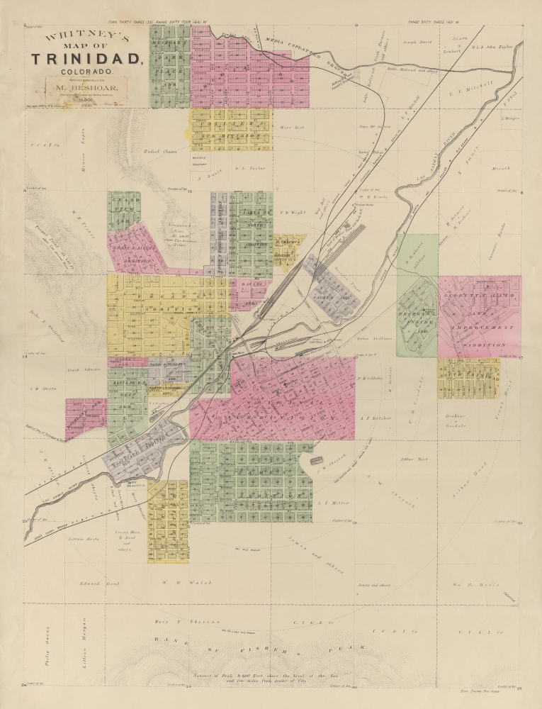
Whitney's Map of Trinidad, Colorado.
1888 (dated) 26.75 x 20 in (67.945 x 50.8 cm) 1 : 9386
1888 (dated) 26.75 x 20 in (67.945 x 50.8 cm) 1 : 9386
Description
An extremely rare 1888 map of Trinidad, Colorado, issued by W. H. Whitney. The map was issued at a heady time in Trinidad's development. The railroads reached Trinidad in the late 1870s, ushering in a boom that lasted until the turn of the century. As a railroad nexus connecting three major lines, Trinidad prospered as a cattle town. Towards the end of the 19th century, massive coal deposits were discovered that further fueled growth. When this map was issued, legendary lawman Bat Masterson was the town marshal, and other colorful characters associated with the old west visited, including Doc Holliday and Wyatt Earp.
Unfinished?
Whitney's 1888 map of Trinidad, Colorado, is the rarest and most unusual map of the Whitney railroad map series. It has an unfinished quality to it, bearing no railroad logo and having no printer's imprint. Moreover, unlike the others, there is no defined outer border. This may be that the example we have here is a proof, and more sophisticated versions were issued, that it was made on a shoestring budget, or that it was unfinished.Exclusively for M. Beshoar
A pastedown near the title states that the map was 'Prepared Exclusively for M. Beshoar'. This would be Dr. Michael Beshoar (1833 - 1907), a prominent physician, politician, and newspaper publisher active in Trinidad from 1867 to his death in 1907. Beshoar was a well-traveled and accomplished individual who has the unusual distinction of having served first in the Confederate Army, then, after being captured and signing an Oath of Amnesty, in the Union Army as a surgeon in Union Army hospitals in Missouri and Nebraska.W. H. Whitney Maps
Between 1887 and 1888, W. H. Whitney issued a series of separate-issue large-scale pocket maps of western cities serviced by the Rio Grande Western Railroad. These are scarce and little-known but include maps of Pueblo, Trinidad, Salt Lake City, and possibly others. Whitney did not survey the maps himself. Instead, they are based on local railroad and real-estate survey work, which he compiled as a cohesive whole. Most feature advertisements for real-estate development companies. In some cases, the same map was be issued multiple times with different promotions. With the exception of Trinidad, however, all bear the Rio Grande Western logo, suggesting that the railroad was underwriting their production. The Rio Grande Western map of Pueblo, likely the first, was printed by Denver Lithography, and its distinctive clean lines, typography, and muted printed color informed all subsequent Whitney city plans. Whitney's work for the Rio Grande Western caught the attention of the Northern Pacific Railroad in 1889, and between 1889 and 1890, he issued similar maps of cities serviced by the Union Pacific and co-shared lines of the Great Northern and Northern Pacific Railroads. These include Salt Lake City, Portland, Seattle, Astoria, Spokane, Port Townsend, Bellingham Bay, and Tacoma. There are potentially others yet to be discovered. Similar to his Colorado maps, these were underwritten by the Union Pacific Railroad, and all bear that firm's logo. The maps are copyrighted to 'W. H. Whitney', filed in Washington D.C. We have tentatively associated this figure with the Boston civil engineer William Henry Whitney, who, after 1888, owned a private civil engineering, surveying, and mapmaking firm in Boston. While Whitney may not have considered the maps important, instead focusing on real-estate development in Boston, they are today one of his most significant legacies. Individually and collectively, they represent some of the earliest obtainable maps of their respective subjects, marking them as important historical records of the urbanization of the American west. Today, all such maps are extremely scarce.Publication History and Census
This map was published in 1888 by W. H. Whitney. It has the character of other maps produced by Whitney for the DRG / RGW between 1888 and 1889 - those being Salt Lake City and Pueblo -, but here there is no railroad imprint. Nor is there a printer's imprint. We are aware of just three surviving examples, Denver Public Library, the University of Colorado Boulder, and Colorado College.Cartographer
William Henry Whitney (January 3, 1843 - May 4, 1909) was an American civil engineer active in Boston in the second half of the 19th century. Whitney was born in Needham, Massachusetts. He studied at Cambridge High School then at the Lawrence Scientific School of Harvard University. In July of 1862, he enlisted in the Union Army to fight in the American Civil War (1861 - 1865). He served honorably throughout the war, seeing action and suffering wounds twice. He left the service with the rank of Brevet-Major. He served as Alderman of Cambridge. and was involved with the Back Bay development project - producing multiple maps and plans. He began his studies as a civil engineer before the war in the office of Stephen P. Fuller. From 1869 - 1871 he worked in the Boston City Engineer's Office and was involved with the Back Bay development project - producing multiple maps and plans. In 1872, he entered into partnership with J. Franklin Fuller, son of S. P. Fuller. After a short time, Fuller retired and Whitney took full control of the firm, in 1888 renaming it William H. Whitney. As a private contractor he continued to work on the Back Bay. Also around this time, he completed multiple plans for the official records of the Civil War. Between 1889 and 1890, he took a contract with the Union Pacific to produce a series of maps of western cities, including Portland, Salt Lake City, Seattle, Astoria, Port Townsend, Spokane, and more. While he did not consider them an important part of his corpus, they are today arguably his most significant works, being among the earliest obtainable plans of those cities. He was also influential in introducing blueprint technology to American architecture and engineering. More by this mapmaker...
Condition
Good. Some discoloration near title.
References
OCLC 7515465. University of Colorado, Boulder G4314.T7P2 1888 .W4.