1949 War Office Survey Map of Tsing Wu, Bao'an County (Shenzhen)
TsingWuHK-waroffice-1949$750.00


Title
Hong Kong and the New Territories. Tsing Wu.
1949 (dated) 25.25 x 34.5 in (64.135 x 87.63 cm) 1 : 20000
1949 (dated) 25.25 x 34.5 in (64.135 x 87.63 cm) 1 : 20000
Description
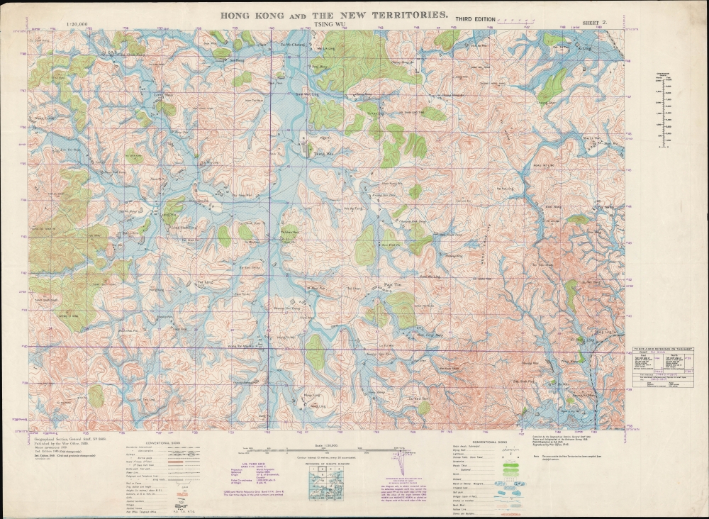
A 1949 British War Office survey map of a portion of Bao'an County, today's Shenzhen, a megacity on the border of Hong Kong that has emerged in the past forty years. This area, the heart of the mainland Chinese operations of the multinational corporation Foxconn, has been completely transformed and is today virtually unrecognizable from the scattered villages and fields depicted here.
However several clues can be gleaned that reveal the true location of the area illustrated on the present map. The name of the village in the title, at center towards top, was changed in later editions of the map to Ch'ing Hu; based on this transliteration and its approximate location in the key map at bottom, Tsing Wu appears to be Qinghu (清湖), now just a neighborhood, with an eponymous metro station, in Shenzhen's Longhua District. The village of Lung Wa at left here is likely the basis for today's Longhua District. The waterways that appear also correspond to those now designated the Guanlan River (观澜河), flowing through Longhua District. The railway at right, with the distinctive curve which brings it into view at bottom-right and top-right, also provides additional confirmation of this location; it is the Canton-Kowloon Railway, which had a station at Ping Wu (Pinghu 平湖), just to the east of the depicted area.
The United Kingdom was the earliest Western power to recognize the People's Republic of China, in January 1950, in a bid to protect Hong Kong. Still, it was not at all clear that Hong Kong would be safe from a Communist invasion, and Britain was hardly in a position to try to defend the colony at the time. We now know that part of the reason the Communists left Hong Kong alone is because it served a vital function as a window to the capitalist world, allowing, for instance, the evasion of a U.S. blockade to receive critical supplies during the Korean War. Though tens of thousands of refugees fled the mainland for Hong Kong in the late 1940s, the border between Hong Kong and 'red' China was quite open in the early-mid 1950s, allowing Hong Kong residents to travel to their home villages and visit relatives. Though this 'travel,' often an excuse for trading, was a thorn in the side of the Communists, who were attempting to institute a strict customs regime and control the flow of precious metals to support the renminbi, it also was an economic boon, especially to Guangdong and Fujian provinces.
A Closer Look
The map covers a portion of Bao'an County, across the mainland Chinese border from the New Territories of the British crown colony of Hong Kong. Information is noted at a granular level of detail, down to irrigated fields, foot paths, and small villages, and seemingly even to individual buildings. Elevation is indicated throughout with contour lines (in meters), demonstrating the sudden changes in elevation between hilltops and river valleys.Identifying the Location
Locating the area seen here on a present-day map presents many difficulties. Frenetic development has reshaped the entire region from the farms and villages depicted here to factories, residential high rises, and broad paved avenues. Moreover, placenames often changed with China's regimes in the 20th century, and the establishment of the People's Republic of China in 1949 was no exception. Finally, the War Office employed English transliterations of Cantonese placenames, whereas a map today would use pinyin based on Mandarin. The longitude and latitude coordinates in the margins are also less helpful than might be imagined because they correspond to an idiosyncratic system developed for the 'Southwest Pacific' region during World War II that does not align with standard coordinates.However several clues can be gleaned that reveal the true location of the area illustrated on the present map. The name of the village in the title, at center towards top, was changed in later editions of the map to Ch'ing Hu; based on this transliteration and its approximate location in the key map at bottom, Tsing Wu appears to be Qinghu (清湖), now just a neighborhood, with an eponymous metro station, in Shenzhen's Longhua District. The village of Lung Wa at left here is likely the basis for today's Longhua District. The waterways that appear also correspond to those now designated the Guanlan River (观澜河), flowing through Longhua District. The railway at right, with the distinctive curve which brings it into view at bottom-right and top-right, also provides additional confirmation of this location; it is the Canton-Kowloon Railway, which had a station at Ping Wu (Pinghu 平湖), just to the east of the depicted area.
Foxconn City
Today, this area is known for its close connection to the Taiwanese company Foxconn, a Fortune Global 500 company which is especially prevalent in the field of electronics, including components and assembly for Apple products. Foxconn opened its first factory in Mainland China in what is now Longhua District in 1988 and has since added many more adjoining facilities, to the extent that the complex (officially the Longhua Science and Technology Park) is often called 'Foxconn City' and employs upwards to 200,000 people.Historical Context
This map was one part of a 24-sheet survey map series of Hong Kong, first undertaken in 1929 - 1930 and updated periodically thereafter. This ambitious undertaking was no doubt one of the largest, if not the largest, topographical surveys of Hong Kong at the time. The updates made after the Second World War (2nd and 3rd editions) were no doubt motivated by taking stock after the city's occupation by the Japanese. But the third edition in 1949 also coincides with the Communist revolution in mainland China, which presented a serious threat to the colony.The United Kingdom was the earliest Western power to recognize the People's Republic of China, in January 1950, in a bid to protect Hong Kong. Still, it was not at all clear that Hong Kong would be safe from a Communist invasion, and Britain was hardly in a position to try to defend the colony at the time. We now know that part of the reason the Communists left Hong Kong alone is because it served a vital function as a window to the capitalist world, allowing, for instance, the evasion of a U.S. blockade to receive critical supplies during the Korean War. Though tens of thousands of refugees fled the mainland for Hong Kong in the late 1940s, the border between Hong Kong and 'red' China was quite open in the early-mid 1950s, allowing Hong Kong residents to travel to their home villages and visit relatives. Though this 'travel,' often an excuse for trading, was a thorn in the side of the Communists, who were attempting to institute a strict customs regime and control the flow of precious metals to support the renminbi, it also was an economic boon, especially to Guangdong and Fujian provinces.
Publication History and Census
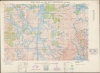
This map was initially produced by the British War Office in 1929. Minor corrections were added in 1939, a second edition was produced in 1945, and this third edition appeared in 1949, with assistance from the Ordnance Survey (subsequent editions were produced in 1952, 1957, and 1969). This is the 2nd Sheet in a series of 24 (a diagram of the full survey is included at bottom-center). This map is not independently cataloged among the holdings of any institution in any edition, while the National Library of Australia holds the entire series, but with individual maps from different editions which are not clearly indicated in the catalog listing.CartographerS
The British War Office (1857 - 1964) was a department of the British Government responsible for the administration of the Royal Army until 1964, when its functions were transferred to the Ministry of Defense. The War Office was to the Royal Army what the Admiralty was to the Royal Navy, and later, the Air Ministry. Within the War Office, the General Staff Topographical Section was responsible for thousands of maps issued for British intelligence and military use. The Topographical Section was renamed Geographical Section in April 1907. Many, once their military use passed, were offered through licensed agents to the general public. The sole London agent for War Office material was Edward Stanford. More by this mapmaker...
The British Ordnance Survey (1791 - present) is the national mapping agency of Great Britain and is one of the largest producers of maps in the world. This non-ministerial department of the government of the United Kingdom is responsible for producing maps of Great Britain and many of its overseas possessions. The history of the Ordnance Survey goes back as far as 1747, following the Jacobite rising, when King George II commissioned a comprehensive military survey of Scotland to assist further campaigns. The result, produced by Paul Sandby, John Mason and William Roy, was the Duke of Cumberland's Map, the first military quality map of the British Isles. This grew into the Principal Triangulation of Great Britain (1783-1853) under William Roy, and eventually lead to the creation of the Ordnance Survey in 1791. Today the Ordnance Survey produces a large variety of paper maps and digital mapping products. Its large scale maps, issued to the scale of 1:10000, available in sheet map form until the 1980s, are now only available digitally. All maps produced by the Ordnance Survey are in copyright for 50 years after publication. Learn More...
Condition
Very good.