This item has been sold, but you can get on the Waitlist to be notified if another example becomes available, or purchase a digital scan.
1851 Black Map of Turkey in Europe
TurkeyEurope-black-1851$50.00

Title
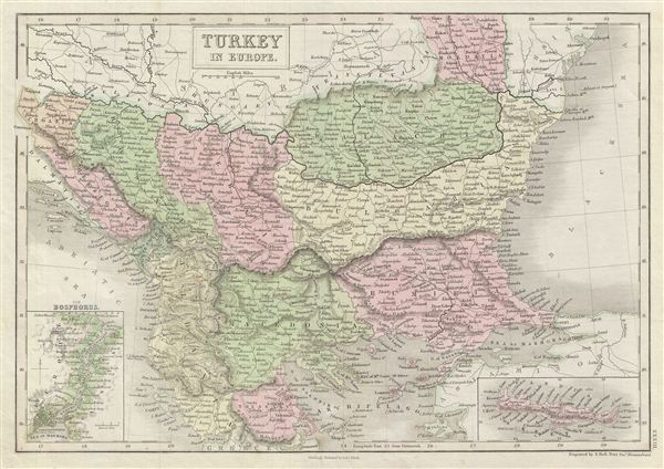
Turkey in Europe.
1851 (undated) 11.5 x 16 in (29.21 x 40.64 cm)
1851 (undated) 11.5 x 16 in (29.21 x 40.64 cm)
Description
A fine example of Adam and Charles Black's 1851 map of the european parts of Turkey. Centered on the Aegean Sea, this map covers from Moldova to Thessaly and from the Adriatic to the Black Sea. This map, drawn when the Ottoman empire controlled much of the region, covers what is today Greece, Turkey, Macedonia, Albania, Bosnia, Serbia, Croatia, Bulgaria, Montenegro, and Moldova. An inset map in the lower left quadrant focuses the Bosporus and Istanbul (Constantinople). Another inset, in the lower right, details the island of Candia or Crete.
This map depicts the waning years of Ottoman hegemony in the region. The Greek Independence movement attained sovereignty for the Peloponnese in 1821. The other Grecian and Balkan states, including Serbia, Croatia, Moldavia, Wallachia, Albania, and Macedonia, remained at least nominally under Ottoman control until 1878.
Throughout, the map identifies various cities, towns, rivers, mountain passes and an assortment of additional topographical details. Map is hand colored in pink, green and yellow pastels to define boundaries. The map is engraved by S. Hall and issued as plate no. XXXIII in the 1851 edition of Black's General Atlas.
CartographerS
Charles and Adam Black (fl. 1807 - present) were map and book publishers based in Edinburgh. Charles and his uncle, Adam, both of Edinburgh, Scotland, founded their publishing firm in 1807. They published a series of maps and atlases throughout the 19th century. In addition to an array of atlases, the Black firm is known for their editions of the Encyclopedia Britannica (1817 - 1826) and the first publishing of Sir Walter Scott's novels in 1854. In 1889 the A. & C. Black publishing house moved to London where it remains in operation to this day. More by this mapmaker...
Sidney Hall (1788 - 1831) was an English engraver and map publisher active in London during the late 18th and early 19th centuries. His earliest imprints, dating to about 1814, suggest a partnership with Michael Thomson, another prominent English map engraver. Hall engraved for most of the prominent London map publishers of his day, including Aaron Arrowsmith, William Faden, William Harwood, and John Thomson, among others. Hall is credited as being one of the earliest adopters of steel plate engraving, a technique that allowed for finer detail and larger print runs due to the exceptional hardness of the medium. Upon his early death - he was only in his 40s - Hall's business was inherited by his wife, Selina Hall, who continued to publish under the imprint, "S. Hall", presumably for continuity. The business eventually passed to Sidney and Selina's nephew Edward Weller, who became extremely prominent in his own right. Learn More...
Source
Black, A. and C., General Atlas Of The World, (Edinburgh) 1851.
Condition
Very good. Blank on verso. Original platemark visible.
References
Rumsey 2305.038 (1854 edition). Philips (atlases) 4334.