This item has been sold, but you can get on the Waitlist to be notified if another example becomes available, or purchase a digital scan.
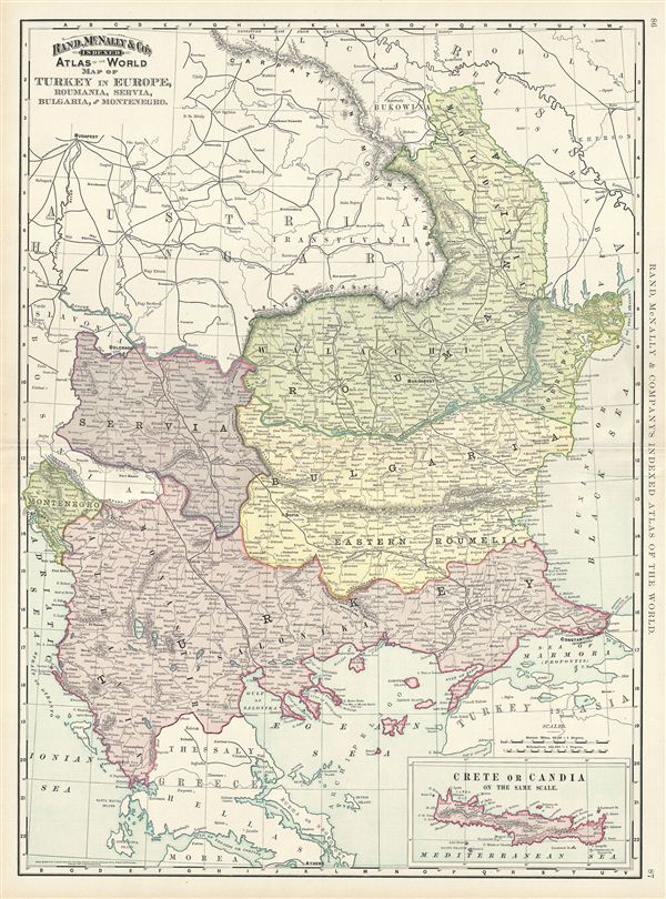
1892 Rand McNally Map of European Turkey
TurkeyEurope-randmcnally-1895$37.50

Title
Map of Turkey in Europe, Roumania, Servia, Bulgaria and Montenegro.
1892 (dated) 27 x 20 in (68.58 x 50.8 cm) 1 : 1964160
1892 (dated) 27 x 20 in (68.58 x 50.8 cm) 1 : 1964160
Description
This is a beautiful example of Rand McNally and Company's 1892 map of european Turkey. It covers Rumelia including modern day Romania, Bulgaria, Serbia, Montenegro, Albania, Macedonia and part of Greece. An inset in the lower right quadrant details Crete or Candia. This map depicts the waning years of Ottoman hegemony in the region. The Greek Independence movement attained sovereignty for the Peloponnese in 1821. The other Grecian and Balkan states, including Serbia, Croatia, Moldavia, Wallachia, Albania, and Macedonia, remained at least nominally under Ottoman control until 1878. A few years after this map was made, around 200,000 Armenian and Christian civilians would be massacred by the Ottomans in the Hamidian massacres. Color coded according to regions and territories, the map notes several towns, cities, rivers and various other topographical details with relief shown by hachure. This map was issued as plate nos. 86 and 87 in the 1895 issue of Rand McNally and Company's Indexed Atlas of the World - possibly the finest atlas Rand McNally ever issued.
Cartographer
Rand, McNally and Co. (fl. 1856 - present) is an American publisher of maps, atlases and globes. The company was founded in 1856 when William H. Rand, a native of Quincy, Massachusetts, opened a print shop in Chicago. Rand hired the recent Irish immigrant Andrew McNally to assist in the shop giving him a wage of 9 USD per week. The duo landed several important contracts, including the Tribune's (later renamed the Chicago Tribune) printing operation. In 1872, Rand McNally produced its first map, a railroad guide, using a new cost effective printing technique known as wax process engraving. As Chicago developed as a railway hub, the Rand firm, now incorporated as Rand McNally, began producing a wide array of railroad maps and guides. Over time, the firm expanded into atlases, globes, educational material, and general literature. By embracing the wax engraving process, Rand McNally was able to dominate the map and atlas market, pushing more traditional American lithographic publishers like Colton, Johnson, and Mitchell out of business. Eventually Rand McNally opened an annex office in New York City headed by Caleb S. Hammond, whose name is today synonymous with maps and atlases, and who later started his own map company, C. S. Hammond & Co. Both firms remain in business. More by this mapmaker...
Source
Rand McNally & Co., Foreign Countries. Rand, McNally & Co's Indexed Atlas of the World (Complete in Two Volumes)…, (Chicago) 1895.
Condition
Very good. Minor wear along original centerfold. Text on verso. Minor verso repair, right margin.
References
Rumsey 3565.021 (1897 edition). Philip (atlases) 1026 (1898 edition).