1845 Ewing Map of Greece and the Balkans
TurkeyGreece-ewing-1845$100.00

Title
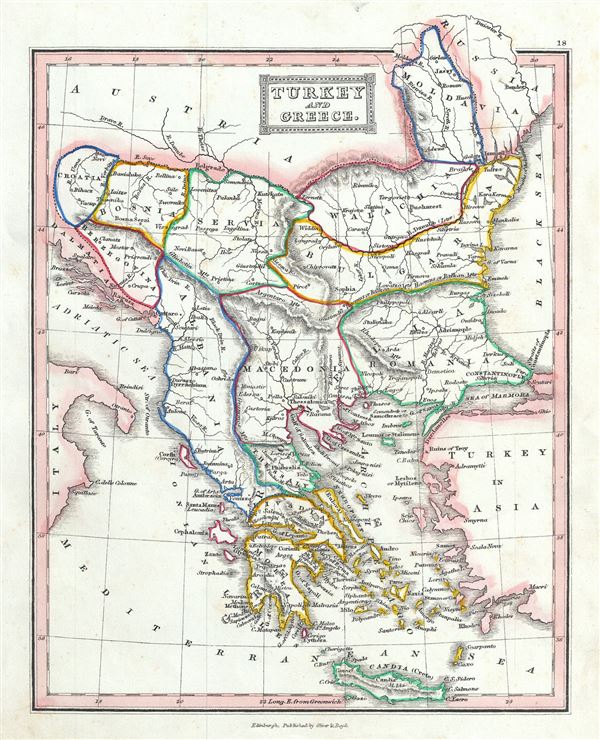
Turkey and Greece.
1845 (undated) 10 x 8 in (25.4 x 20.32 cm) 1 : 6800000
1845 (undated) 10 x 8 in (25.4 x 20.32 cm) 1 : 6800000
Description
This is a beautiful example of Thomas Ewing's 1845 map of the European parts of Turkey. Centered on the Aegean Sea, this map covers from Moldavia to Thessaly and from the Adriatic to the Black Sea. Drawn when the Ottoman Empire controlled much of the region, it covers what is today Greece, Turkey, Macedonia, Albania, Bosnia, Serbia, Croatia, Bulgaria, Montenegro, and Moldova. Throughout, the map identifies various cities, towns, rivers, mountain passes and an assortment of additional topographical details.
This map depicts the waning years of Ottoman hegemony in the region. The Greek Independence movement attained sovereignty for the Peloponnese in 1821. The other Grecian and Balkan states, including Serbia, Croatia, Moldavia, Wallachia, Albania, and Macedonia, remained at least nominally under Ottoman control until 1878.
This map was published in 1845 by Oliver and Boyd as part of Ewing's New General Atlas.
Source
Oliver and Boyd, Ewing's New General Atlas: containing Distinct Maps of all the Principal States and Kingdoms throughout the World, (Edinburgh) 1845.
Condition
Very good. Minor foxing at places. Blank on verso.