This item has been sold, but you can get on the Waitlist to be notified if another example becomes available, or purchase a digital scan.
1794 Laurie and Whittle / Jefferys Map of the Turks Islands, Turks and Caicos
Turks-lauriewhittle-1794$475.00


Title
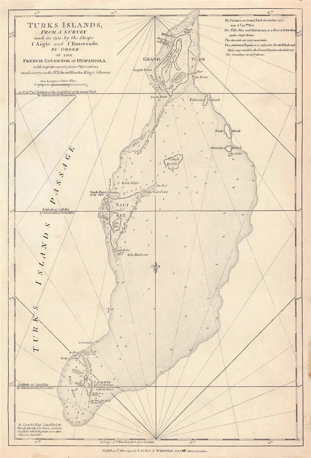
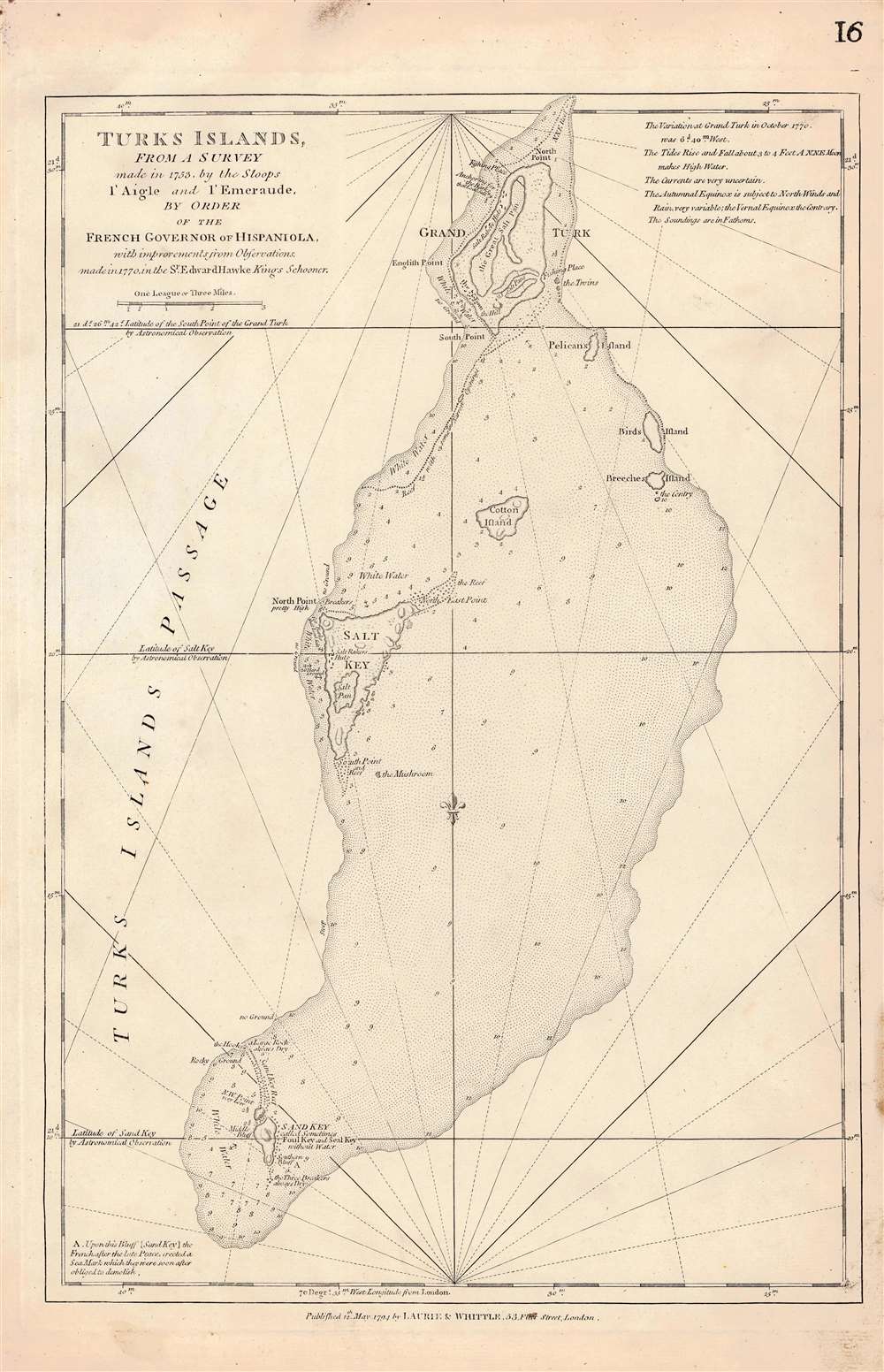
Turks Islands, from a survey made in 1753, by the Sloops l'Aigle and l'Emeraude by order of the French Governor of Hispaniola.
1794 (undated) 18.5 x 12.25 in (46.99 x 31.115 cm) 1 : 85000
1794 (undated) 18.5 x 12.25 in (46.99 x 31.115 cm) 1 : 85000
Description
This is the 1794 Laurie and Whittle edition of Thomas Jeffrys' map of the Turks Islands, among the earliest maps to focus on the islands. The map shows not only Grand Turk, Salt Key, and Sand Key but also the shallows linking these islands, as well as several smaller. As such, the map - with copious depth soundings, anchorages, and notations - is able to emphasize the many localized navigational hazards. As small as they are, the Turks were an important resource: its tiny population produced salt from sea brine. (Indeed, the only settlements noted on the map are 'Salt rakers' huts.' During the American Revolution the Continental Army depended on Turks and Caicos salt for food preservation, and American fishing vessels used Turks salt to preserve their catches. Jefferys credited the a 1753 survey attributed to the French schooners l'Aigle and l'Emeraude, further amended in 1770 by the British sloop Sir Edward Hawke (the sloop, not Sir Edward himself, who was by this time First Lord of the Admiralty and above such chores.)
Publication History and Census
The map was engraved by Thomas Jefferys in 1775 for inclusion in his West India Atlas. Further editions were produced without substantial change for later issues of the Atlas, as well as in Sayer and Bennet's smaller The West India Islands: From Actual Survey and Observations..., the work in which this example appeared after Sayer and Bennet's business passed to Laurie and Whittle. Both of these atlases are well represented in institutional collections in their various editions. We see some thirteen examples of the separate map catalogued in OCLC.CartographerS
Laurie and Whittle (fl. 1794 - 1858) were London, England, based map and atlas publishers active in the late 18th and early 19th century. Generally considered to be the successors to the Robert Sayer firm, Laurie and Whittle was founded by Robert Laurie (c. 1755 - 1836) and James Whittle (1757-1818). Robert Laurie was a skilled mezzotint engraver and is known to have worked with Robert Sayer on numerous projects. James Whittle was a well-known London socialite and print seller whose Fleet Street shop was a popular haunt for intellectual luminaries. The partnership began taking over the general management of Sayer's firm around 1787; however, they did not alter the Sayer imprint until after Sayer's death in 1794. Apparently Laurie did most of the work in managing the firm and hence his name appeared first in the "Laurie and Whittle" imprint. Together Laurie and Whittle published numerous maps and atlases, often bringing in other important cartographers of the day, including Kitchin, Faden, Jefferys and others to update and modify their existing Sayer plates. Robert Laurie retired in 1812, leaving the day to day management of the firm to his son, Richard Holmes Laurie (1777 - 1858). Under R. H. Laurie and James Whittle, the firm renamed itself "Whittle and Laurie". Whittle himself died six years later in 1818, and thereafter the firm continued under the imprint of "R. H. Laurie". After R. H. Laurie's death the publishing house and its printing stock came under control of Alexander George Findlay, who had long been associated with Laurie and Whittle. Since, Laurie and Whittle has passed through numerous permeations, with part of the firm still extant as an English publisher of maritime or nautical charts, 'Imray, Laurie, Norie and Wilson Ltd.' The firm remains the oldest surviving chart publisher in Europe. More by this mapmaker...
Thomas Jefferys (1695 - November 20, 1771) was one of the most prominent and prolific map publishers and engravers of his day. Jefferys was born in Birmingham and was apprenticed to the engraver Emmanuel Bowen in 1735. Later, in the 1740s he engraved several maps for the popular periodical Gentleman's Magazine. Around 1740 Jefferys was finally able to go into business for himself and in 1746 received an appointment as 'Geographer to Fredrick, Prince of Wales,' which shortly after translated to the position of 'Royal Cartographer to King George III.' Jefferys initially specialized in compiling and re-engraving the works of earlier cartographers into more coherent cartographic wholes. Later, while not salaried position, Jefferys' appointment as 'Royal Cartographer' guaranteed preferential access to the most up to date cartographic material available, allowing him to produce new and updated charts of exceptional accuracy. He his best known for his maps of the Americas, particularly the posthumously published 1775 American Atlas, which included some of the finest and most important late colonial era maps of America ever made. Despite his prolific publishing history, royal appointments, and international publishing fame, Jefferys lived most of his life in dire economic straits. He was bailed out of bankruptcy by Robert Sayer during the production of the American Atlas. In the end, Jefferys died suddenly with very little to his name. Nonetheless, his cartographic legacy survived, and even after his death in 1771, many of his important maps continued to be published and republished by Sayer and Bennet, Conrad Lotter, Georges Louis Le Rouge, Laurie and Whittle, and others. Many attribute some of Jefferys best maps to the colorful and criminally inclined Irish cartographic genius Braddock Mead (John Green, c. 1688 - 1757), who is considered the 'secret behind Jefferys.' Jefferys was succeeded by his son, also Thomas, who had little success as a cartographer and eventually partnered with, then sold his stock and plates to William Faden - Jefferys' true heir. Learn More...
Source
Laurie, R. H. and Whittle, J., The West-India islands... (London: Laurie and Whittle), 1796.
Condition
Excellent condition. Some marginal staining.
References
OCLC 557761805. Rumsey 4723.039 (1775). Phillips, Philip Lee, A List of Geographical Atlases in the Library of Congress, 3946 #17.