This item has been sold, but you can get on the Waitlist to be notified if another example becomes available, or purchase a digital scan.
1712 Wells Map of Greece, the Balkans, Macedonia and Turkey in Europe
TurkyInEurope-wells-1712$200.00

Title
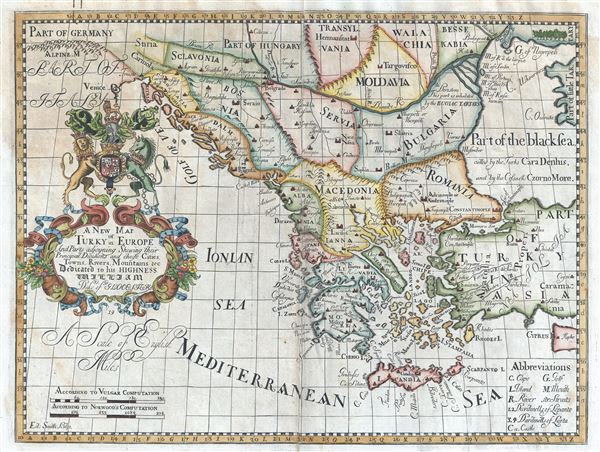
A New Map of Turky in Europe And Parts adjoyning Shewing their Principal Divisions and chiefe Cities, Towns, Rivers, Mountains etc. Dedicated to his Highness William Duke of Glocester.
1712 (undated) 15 x 20 in (38.1 x 50.8 cm) 1 : 4500000
1712 (undated) 15 x 20 in (38.1 x 50.8 cm) 1 : 4500000
Description
This is an attractive 1712 map of Greece, the Balkans, Macedonia and Turkey in Europe by Edward Wells of Oxford. Centered on modern day Greece, it covers from Transylvania and Hungary to Crete and the Mediterranean and from Venice east as far as Cyprus, inclusive of modern day Greece, Bulgaria, Romania, Macedonia, Albania, Serbia, Bosnia and Herzegovina, Montenegro, Croatia, Slovenia and Moldova. The Greek Isles are well represented. It notes towns, islands, rivers, capes, and a host of other topographical features. The map depicts the region when most of Greece and the Balkans were under the control of the Ottoman Turks.
A decorative cartouche appears on the left of the map featuring the coat of arms of the Duke of Gloucester. This, like many other Wells maps, is dedicated to Prince William, Duke of Gloucester and son of Queen Anne, who, when this map was being prepared, was a student at Oxford. Engraved by Smith and published by T. Bonwicke for the 1712 edition of Edward Wells' Atlas, A New Sett of Maps both of Ancient and Present Geography.
A decorative cartouche appears on the left of the map featuring the coat of arms of the Duke of Gloucester. This, like many other Wells maps, is dedicated to Prince William, Duke of Gloucester and son of Queen Anne, who, when this map was being prepared, was a student at Oxford. Engraved by Smith and published by T. Bonwicke for the 1712 edition of Edward Wells' Atlas, A New Sett of Maps both of Ancient and Present Geography.
Cartographer
Edward Wells (1667 - 1727) was an English mathematician, geographer, and classical scholar based at Christ Church College, Oxford. Wells trained for the ministry but quickly found himself unsuited to religious life and instead applied for an academic position at Oxford, where he authored numerous well respected works on a wide range of mathematical and scientific topics. He tutored Prince William, the sickly son of Queen Anne, who was likely about 11 at the time this map was prepared. Wells dedicated nearly all of the maps in his atlas, A New Sett of Maps both of Ancient and Present Geography, to the young prince - quite possibly posthumously, as William died in July of 1700 shortly prior to the publication of the atlas. Nonetheless, Wells' geography proved popular and was published in number editions well into the 1730s. More by this mapmaker...
Source
Wells, E., A New Sett of Maps both of Ancient and Present Geography, (London, T. w. Bonwicke) c. 1712.
A New Sett of Maps both of Ancient and Present Geography was published by Edward Wells in various editions between 1701 and 1730. The publication contained some 40 maps all of which were dedicated to Prince William, Duke of Gloucester. Wells tutored the young prince at Christchurch, Oxford and seems to have developed a close relationship with him. At just 11 years of age, William died in 1700 and never had the opportunity to see the published work that he inspired. The atlas was intended for educational purposes with a focus on school use.
Condition
Very good. Some wear and spotting along original centerfold. Some foxing in top left quadrant. Original platemark visible. Professionally flattened and backed with archival tissue.
References
New York Public Library, Map Division, OCLC : 7143148 (1700 edition).