This item has been sold, but you can get on the Waitlist to be notified if another example becomes available, or purchase a digital scan.
1721 De Wit Map of Southwest Ukraine
UkrainaePodolia-covensmortier-1721$750.00

Title
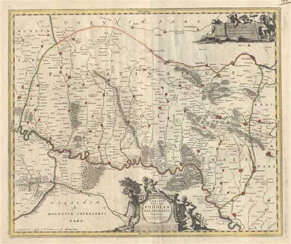
Ukrainae pars, quea Podolia Palatinatus Vulgo dicitur.
1721 (undated) 18.5 x 22 in (46.99 x 55.88 cm) 1 : 470000
1721 (undated) 18.5 x 22 in (46.99 x 55.88 cm) 1 : 470000
Description
This is a scarce c.1721 Covens and Mortier edition of the map of the southwestern parts of Ukraine and vicinity. It covers the historic area of Eastern Europe known at the time as Podolia. It covers the regions around the Dniester River. The entire map is depicted in extraordinary detail, offering both topographical and political information, with forests and mountains beautifully rendered in profile.
This map was originally based on Guillaume le Vasseur de Beauplan’s map. Beauplan, commissioned by the King of Poland, produced detailed maps of the Ukraine, based on his surveys. Later, Joan Bleau created four maps of Ukraine based on Beauplan’s work detailing the regions of Pokuttya, Podillya, Bratslavschyna and Kyiv. This is the second map in that series. The map was printed shortly following the 1721 Covens and Mortier acquisition of the original plates.
This map was originally based on Guillaume le Vasseur de Beauplan’s map. Beauplan, commissioned by the King of Poland, produced detailed maps of the Ukraine, based on his surveys. Later, Joan Bleau created four maps of Ukraine based on Beauplan’s work detailing the regions of Pokuttya, Podillya, Bratslavschyna and Kyiv. This is the second map in that series. The map was printed shortly following the 1721 Covens and Mortier acquisition of the original plates.
Cartographer
Covens and Mortier (1721 - c. 1862) was an Amsterdam publishing firm, the successor to the extensive publishing empire built by Pierre Mortier (1661 - 1711). Covens and Mortier maps are often criticized as derivative - but this is not fully the case. Pierre Mortier lived in Paris from 1681 to 1685. There he established close relationships the the greatest French cartographers of the era, including De L'Isle and D'Anville. His business model was based upon leveraging Dutch printing technology and sophistication to co-publish state of the art French cartography. Upon Mortier's death in 1711 his firm was taken over by his son, Cornelius Mortier (1699 - 1783). Cornelius married the sister of Johannes Covens (1697 - 1774) in 1721 and, partnering with his brother in law, established the Covens and Mortier firm. Under the Covens and Mortier imprint, Cornelius and Johannes continued in Pierre's model of publishing the most up-to-date French works with permission. They quickly became one of the largest and most prolific Dutch publishing concerns of the 18th century. The firm and its successors published thousands of maps over a 120 year period from 1721 to the mid-1800s. During their long lifespan the Covens and Mortier firm published as Covens and Mortier (1721 - 1778), J. Covens and Son (1778 - 94) and Mortier, Covens and Son (1794 - c. 1862). More by this mapmaker...
Condition
Very good. Overall age toning. Minor wear along original centerfold. Minor spotting throughout.