This item has been sold, but you can get on the Waitlist to be notified if another example becomes available, or purchase a digital scan.
1900 MacAlister Map of Route to Emerald Mines of Jebel Sikait District, Egypt
UmSelimSikait-macalister-1900$87.50

Title
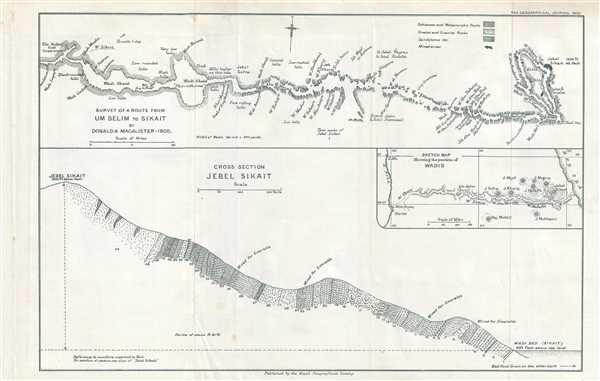
Survey of a Route From Um Selim to Sikait.
1900 (dated) 9 x 13.75 in (22.86 x 34.925 cm) 1 : 316800
1900 (dated) 9 x 13.75 in (22.86 x 34.925 cm) 1 : 316800
Description
This is a 1900 Donald A. MacAlister route map from Um Selim to the Sikait District in Egypt. Incredibly detailed, MacAlister notes numerous waypoints in his party's trek from Um Selim to Jebel Sikait along several wâdis. Different rock formations are noted along the trek, including metamorphic and granite formations. A cross section of Jebel Sikait is included below the route map, along with an inset map of the wâdis in the region.
This map was drawn by Donald A. MacAlister and published in the Geographical Journal by the Royal Geographical Society in 1900.
The Expedition and the Emerald Mines
Equipped by Edwin Streeter of Streeter and Company, a London-based jeweler, MacAlister and his party were charged with investigating 'the so-called 'Cleopatra's Emerald Mines'.' Known since the time pf the Ptolemaic Egyptians, these mines had been exploited by both the Egyptians and later by the Romans. They were 'rediscovered' by Frederic Cailliaud in 1817 but had unsuccessfully been exploited over the next century by various different commercial ventures. By 1899, Edwin Streeter held a concession to work the mines, leading to the outfitting of MacAlister's party. Sikait is located only 15 miles from the Red Sea 'as the crow flies' per MacAlister.This map was drawn by Donald A. MacAlister and published in the Geographical Journal by the Royal Geographical Society in 1900.
Cartographer
Royal Geographical Society (fl. 1830 - present) is a British Society established in 1830 to promote geographical science and exploration. Originally titled the "Geographical Society of London", the RGS received its royal charter from Queen Victoria in 1859 shortly after absorbing several similar but more regional societies including the African Association, the Raleigh Club and the Palestine Association. The RGS sponsored many of the most important and exciting voyages of exploration ever undertaken, including the exploration of Charles Darwin, David Livingstone, Robert Falcon Scott, Richard F. Burton, John Speke, George Hayward, H. M Stanley, Ernest Shackleton and Sir Edmond Hillary. Today, the RGS remains a leading global sponsor of geographical and scientific studies. The Society is based in Lowther Lodge, South Kensington, London. More by this mapmaker...
Source
The Geographical Journal Vol. XVI, No. 5, November 1900.
Condition
Very good. Even overall toning. Slight wear along original fold lines. Blank on verso.